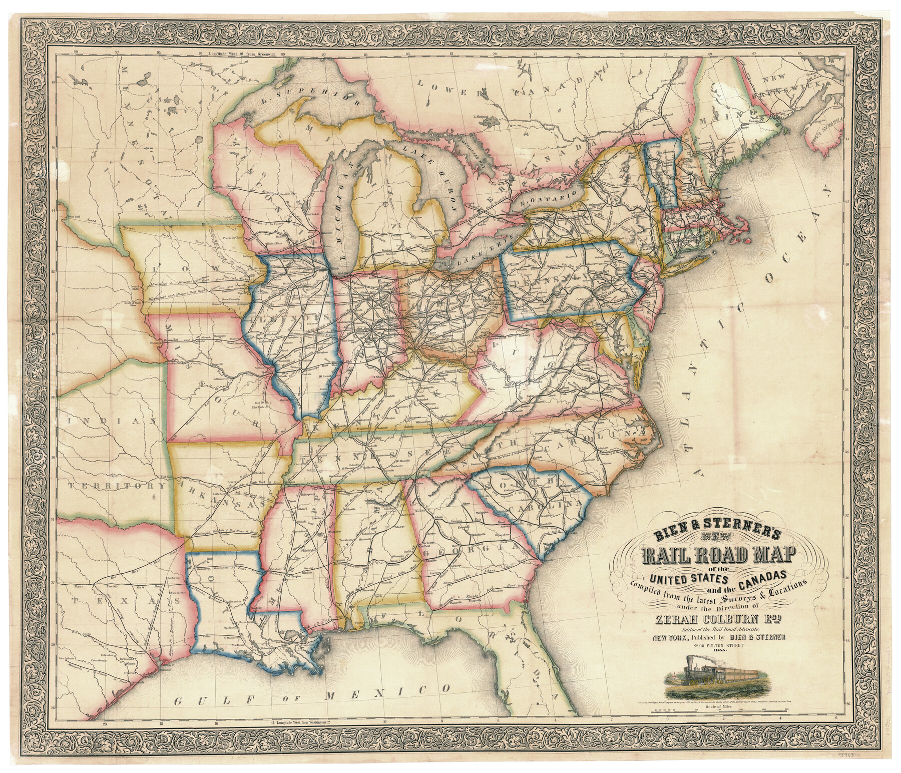
Bien & Sterner's New Rail Road Map of the United States and the Canadas compiled from the latest surveys & locations under the direction of Zerah Colburn Esq., editor of the Rail Road Advocate
-
Map/Doc
95963
-
Collection
General Map Collection
-
Object Dates
1855 (Creation Date)
-
People and Organizations
Bien & Sterner (Publisher)
Zerah Colburn (Surveyor/Engineer)
-
Subjects
Railroads United States
-
Height x Width
27.5 x 32.3 inches
69.9 x 82.0 cm
-
Medium
paper, etching/engraving/lithograph
Related maps
Bien & Sterner’s New Rail Road Map of the United States

Price $20.00
Bien & Sterner’s New Rail Road Map of the United States
2022
Size 3.6 x 4.9 inches
Map/Doc 97020
Part of: General Map Collection

Llano County Sketch File 11

Print $10.00
- Digital $50.00
Llano County Sketch File 11
1885
Size 9.5 x 8.5 inches
Map/Doc 30375
Map of the City of Austin Texas

Map of the City of Austin Texas
1933
Size 22.5 x 17.6 inches
Map/Doc 76050
Crockett County Working Sketch 54

Print $20.00
- Digital $50.00
Crockett County Working Sketch 54
1951
Size 34.5 x 30.7 inches
Map/Doc 68387
McMullen County Sketch File 17

Print $4.00
- Digital $50.00
McMullen County Sketch File 17
Size 8.0 x 10.0 inches
Map/Doc 31369
Wood County Working Sketch 20

Print $40.00
- Digital $50.00
Wood County Working Sketch 20
1985
Size 42.6 x 48.6 inches
Map/Doc 62020
Comal County Sketch File 8 1/2

Print $22.00
- Digital $50.00
Comal County Sketch File 8 1/2
1858
Size 9.2 x 7.4 inches
Map/Doc 19015
Jasper County Working Sketch 15

Print $20.00
- Digital $50.00
Jasper County Working Sketch 15
1925
Size 26.8 x 22.1 inches
Map/Doc 66477
Denton County Working Sketch 33

Print $20.00
- Digital $50.00
Denton County Working Sketch 33
2002
Size 35.3 x 46.1 inches
Map/Doc 78203
Donley County Sketch File B4

Print $20.00
- Digital $50.00
Donley County Sketch File B4
1918
Size 33.3 x 21.8 inches
Map/Doc 11374
Grayson County Rolled Sketch 2

Print $20.00
- Digital $50.00
Grayson County Rolled Sketch 2
1951
Size 25.5 x 42.5 inches
Map/Doc 6030
San Patricio County NRC Article 33.136 Sketch 2

Print $40.00
- Digital $50.00
San Patricio County NRC Article 33.136 Sketch 2
2003
Size 24.3 x 36.0 inches
Map/Doc 87923
You may also like
Medina County Rolled Sketch 8

Print $20.00
- Digital $50.00
Medina County Rolled Sketch 8
1975
Size 24.8 x 25.5 inches
Map/Doc 6742
Mapa Original de Texas por El Ciudadano Estevan F. Austin Presentado al Exmo. Sr. Presidente por su autor 1829

Print $20.00
Mapa Original de Texas por El Ciudadano Estevan F. Austin Presentado al Exmo. Sr. Presidente por su autor 1829
1829
Size 33.4 x 28.1 inches
Map/Doc 76201
[Southern Pacific Rail Road Co. Blocks 15 and 16 in Mitchell, Sterling and Coke Counties]
![91838, [Southern Pacific Rail Road Co. Blocks 15 and 16 in Mitchell, Sterling and Coke Counties], Twichell Survey Records](https://historictexasmaps.com/wmedia_w700/maps/91838-1.tif.jpg)
Print $20.00
- Digital $50.00
[Southern Pacific Rail Road Co. Blocks 15 and 16 in Mitchell, Sterling and Coke Counties]
Size 34.5 x 29.2 inches
Map/Doc 91838
Hays County Working Sketch 3

Print $20.00
- Digital $50.00
Hays County Working Sketch 3
1925
Size 28.2 x 24.1 inches
Map/Doc 66077
Briscoe County Sketch File A-1

Print $16.00
- Digital $50.00
Briscoe County Sketch File A-1
1894
Size 10.7 x 8.4 inches
Map/Doc 16399
Tyler County Sketch File 28

Print $46.00
- Digital $50.00
Tyler County Sketch File 28
1960
Size 9.8 x 8.6 inches
Map/Doc 38699
Flight Mission No. DIX-10P, Frame 83, Aransas County

Print $20.00
- Digital $50.00
Flight Mission No. DIX-10P, Frame 83, Aransas County
1956
Size 18.7 x 22.3 inches
Map/Doc 83944
Flight Mission No. DAG-23K, Frame 164, Matagorda County

Print $20.00
- Digital $50.00
Flight Mission No. DAG-23K, Frame 164, Matagorda County
1953
Size 18.6 x 22.3 inches
Map/Doc 86502
[T. J. Chambers' grant]
![319, [T. J. Chambers' grant], General Map Collection](https://historictexasmaps.com/wmedia_w700/maps/319.tif.jpg)
Print $2.00
- Digital $50.00
[T. J. Chambers' grant]
1847
Size 7.1 x 7.1 inches
Map/Doc 319
Plat in Hockley County, Texas

Print $20.00
- Digital $50.00
Plat in Hockley County, Texas
1956
Size 26.9 x 21.3 inches
Map/Doc 92221
Sterling County Sketch File 4

Print $20.00
- Digital $50.00
Sterling County Sketch File 4
1906
Size 19.4 x 26.0 inches
Map/Doc 12356
[Beaumont, Sour Lake and Western Ry. Right of Way and Alignment - Frisco]
![64123, [Beaumont, Sour Lake and Western Ry. Right of Way and Alignment - Frisco], General Map Collection](https://historictexasmaps.com/wmedia_w700/maps/64123.tif.jpg)
Print $20.00
- Digital $50.00
[Beaumont, Sour Lake and Western Ry. Right of Way and Alignment - Frisco]
1910
Size 20.4 x 46.2 inches
Map/Doc 64123