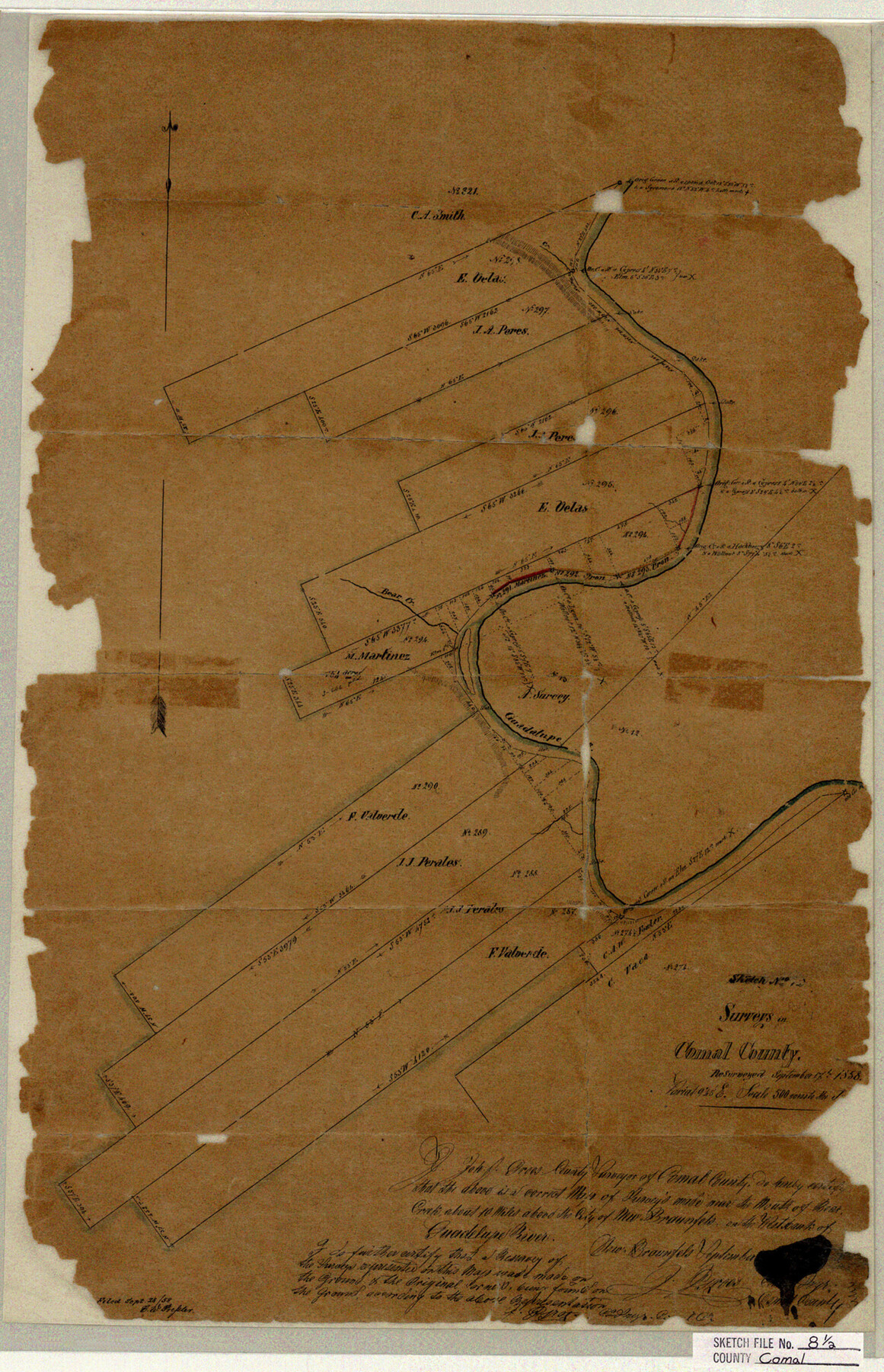
Comal County Sketch File 8 1/2
[Sketch of surveys on the west side of the Guadalupe River and north and south of Bear Creek]
-
Map/Doc
19015
-
Collection
General Map Collection
-
Object Dates
9/17/1858 (Creation Date)
9/28/1858 (File Date)
9/7/1858 (Survey Date)
-
People and Organizations
John J. Groos (Surveyor/Engineer)
-
Counties
Comal
-
Subjects
Surveying Sketch File
-
Height x Width
9.2 x 7.4 inches
23.4 x 18.8 cm
-
Medium
paper, manuscript
-
Scale
1" = 500 varas
-
Features
Bear Creek
Guadalupe River
Part of: General Map Collection

[Surveys along the Trinity River]
![321, [Surveys along the Trinity River], General Map Collection](https://historictexasmaps.com/wmedia_w700/maps/321.tif.jpg)
Print $2.00
- Digital $50.00
[Surveys along the Trinity River]
Size 3.6 x 3.7 inches
Map/Doc 321
Parker County Sketch File 37

Print $4.00
- Digital $50.00
Parker County Sketch File 37
Size 4.8 x 8.1 inches
Map/Doc 33581
Bee County Sketch File 2

Print $40.00
- Digital $50.00
Bee County Sketch File 2
Size 14.3 x 13.0 inches
Map/Doc 14259
Trinity County Sketch File 10

Print $8.00
- Digital $50.00
Trinity County Sketch File 10
1858
Size 13.1 x 8.0 inches
Map/Doc 38527
Kendall County Sketch File 14

Print $4.00
- Digital $50.00
Kendall County Sketch File 14
1860
Size 8.1 x 10.2 inches
Map/Doc 28701
Kleberg County Rolled Sketch 10-6

Print $20.00
- Digital $50.00
Kleberg County Rolled Sketch 10-6
1951
Size 38.0 x 39.1 inches
Map/Doc 9399
Crockett County Working Sketch 86

Print $20.00
- Digital $50.00
Crockett County Working Sketch 86
1976
Size 34.7 x 38.0 inches
Map/Doc 68419
Scarborough's Map of the New England States Vermont, New Hampshire, Maine, Massachusetts, Rhode Island and Connecticut

Print $40.00
- Digital $50.00
Scarborough's Map of the New England States Vermont, New Hampshire, Maine, Massachusetts, Rhode Island and Connecticut
1910
Size 58.3 x 40.1 inches
Map/Doc 97106
Morris County Rolled Sketch 2A

Print $20.00
- Digital $50.00
Morris County Rolled Sketch 2A
Size 22.2 x 17.3 inches
Map/Doc 10265
Galveston County Working Sketch 9

Print $20.00
- Digital $50.00
Galveston County Working Sketch 9
1948
Size 31.9 x 25.8 inches
Map/Doc 69346
King County Sketch File 9

Print $20.00
- Digital $50.00
King County Sketch File 9
Size 23.5 x 33.0 inches
Map/Doc 11937
You may also like
A Portion of Yoakum County, Texas and Gaines County, Texas in the vicinity of the Wasson Oil Field

Print $20.00
- Digital $50.00
A Portion of Yoakum County, Texas and Gaines County, Texas in the vicinity of the Wasson Oil Field
Size 43.4 x 32.0 inches
Map/Doc 90808
Terry County Sketch File 15

Print $10.00
- Digital $50.00
Terry County Sketch File 15
1944
Size 11.3 x 8.9 inches
Map/Doc 38034
Matagorda County Working Sketch Graphic Index, Sheet 2 (Sketches 17 to Most Recent)

Print $40.00
- Digital $50.00
Matagorda County Working Sketch Graphic Index, Sheet 2 (Sketches 17 to Most Recent)
1920
Size 40.1 x 48.6 inches
Map/Doc 76634
Grimes County

Print $40.00
- Digital $50.00
Grimes County
1922
Size 55.7 x 28.2 inches
Map/Doc 77296
Hudspeth County Working Sketch 41

Print $20.00
- Digital $50.00
Hudspeth County Working Sketch 41
1981
Size 18.3 x 37.1 inches
Map/Doc 66326
The Chief Justice County of Red River. Undated

Print $20.00
The Chief Justice County of Red River. Undated
2020
Size 16.6 x 21.8 inches
Map/Doc 96065
Flight Mission No. DQN-2K, Frame 43, Calhoun County

Print $20.00
- Digital $50.00
Flight Mission No. DQN-2K, Frame 43, Calhoun County
1953
Size 18.6 x 22.6 inches
Map/Doc 84248
Thomas Ross Survey

Print $20.00
- Digital $50.00
Thomas Ross Survey
1954
Size 16.8 x 17.6 inches
Map/Doc 92181
Reagan County Working Sketch 36

Print $20.00
- Digital $50.00
Reagan County Working Sketch 36
1966
Size 29.6 x 20.6 inches
Map/Doc 71878
Midland County Working Sketch 7

Print $20.00
- Digital $50.00
Midland County Working Sketch 7
1950
Size 34.6 x 28.3 inches
Map/Doc 70987
Polk County Sketch File 24

Print $20.00
- Digital $50.00
Polk County Sketch File 24
Size 14.3 x 30.8 inches
Map/Doc 12193
East Part of West Bay and Southwest Part of Galveston Bay, Galveston County, showing Subdivision for Mineral Development

Print $40.00
- Digital $50.00
East Part of West Bay and Southwest Part of Galveston Bay, Galveston County, showing Subdivision for Mineral Development
1963
Size 42.2 x 58.2 inches
Map/Doc 1906