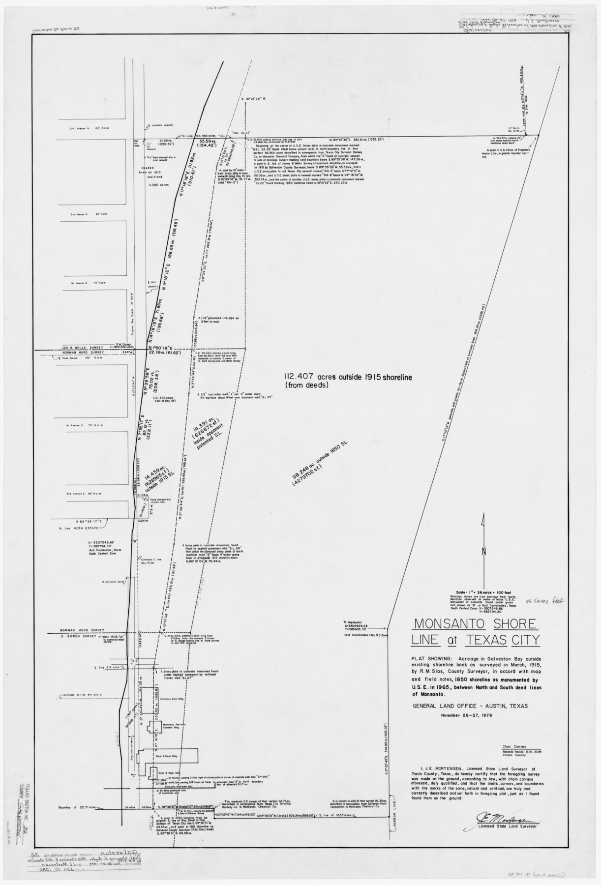
Galveston County Rolled Sketch 32
Monsanto Shoreline at Texas City
-
Map/Doc
9015
-
Collection
General Map Collection
-
Object Dates
11/27/1979 (Creation Date)
1/10/1980 (File Date)
-
People and Organizations
James E. Mortensen (Surveyor/Engineer)
Rosendo V. Molina (Chainman/Field Personnel)
Preston R. Connally (Chainman/Field Personnel)
-
Counties
Galveston
-
Subjects
Surveying Rolled Sketch
-
Height x Width
44.3 x 31.0 inches
112.5 x 78.7 cm
-
Medium
mylar, print
-
Scale
1" = 36 varas
Part of: General Map Collection
Pecos County Working Sketch 44

Print $20.00
- Digital $50.00
Pecos County Working Sketch 44
1945
Size 29.6 x 35.0 inches
Map/Doc 71516
Crockett County Rolled Sketch 46B

Print $20.00
- Digital $50.00
Crockett County Rolled Sketch 46B
1954
Size 24.7 x 13.9 inches
Map/Doc 5594
Outer Continental Shelf Leasing Maps (Louisiana Offshore Operations)

Print $20.00
- Digital $50.00
Outer Continental Shelf Leasing Maps (Louisiana Offshore Operations)
1954
Size 16.2 x 16.3 inches
Map/Doc 76107
Karnes County Working Sketch 3

Print $20.00
- Digital $50.00
Karnes County Working Sketch 3
1943
Size 34.6 x 31.4 inches
Map/Doc 66651
Duval County Sketch File 54

Print $20.00
- Digital $50.00
Duval County Sketch File 54
1937
Size 19.0 x 26.4 inches
Map/Doc 11403
Plat of South 1/2 of Colorado River Channel in McCulloch Co., Texas from Concho County line down river 34 mile 315 varas

Print $40.00
- Digital $50.00
Plat of South 1/2 of Colorado River Channel in McCulloch Co., Texas from Concho County line down river 34 mile 315 varas
1918
Size 41.5 x 104.6 inches
Map/Doc 2463
Karnes County Working Sketch 9

Print $20.00
- Digital $50.00
Karnes County Working Sketch 9
1962
Size 37.1 x 28.9 inches
Map/Doc 66657
Roberts County Sketch File 1

Print $20.00
- Digital $50.00
Roberts County Sketch File 1
Size 39.2 x 22.3 inches
Map/Doc 10589
San Jacinto County Sketch File 13a

Print $6.00
San Jacinto County Sketch File 13a
Size 8.2 x 13.0 inches
Map/Doc 35725
Terrell County Sketch File 22A

Print $20.00
- Digital $50.00
Terrell County Sketch File 22A
Size 21.7 x 11.4 inches
Map/Doc 12422
Stephens County Working Sketch 39

Print $20.00
- Digital $50.00
Stephens County Working Sketch 39
1995
Size 25.5 x 27.1 inches
Map/Doc 63982
Maps of Gulf Intracoastal Waterway, Texas - Sabine River to the Rio Grande and connecting waterways including ship channels

Print $20.00
- Digital $50.00
Maps of Gulf Intracoastal Waterway, Texas - Sabine River to the Rio Grande and connecting waterways including ship channels
1966
Size 14.5 x 22.3 inches
Map/Doc 61933
You may also like

Austin County Boundary File 3

Print $2.00
- Digital $50.00
Austin County Boundary File 3
Size 14.3 x 8.6 inches
Map/Doc 50243
John Slaughter Ranch

Print $40.00
- Digital $50.00
John Slaughter Ranch
Size 38.0 x 52.7 inches
Map/Doc 89952
Hansford County Sketch File 7

Print $4.00
- Digital $50.00
Hansford County Sketch File 7
1927
Size 12.2 x 8.8 inches
Map/Doc 24958
[Mrs. May Vinson Survey]
![91943, [Mrs. May Vinson Survey], Twichell Survey Records](https://historictexasmaps.com/wmedia_w700/maps/91943-1.tif.jpg)
Print $20.00
- Digital $50.00
[Mrs. May Vinson Survey]
Size 25.0 x 14.6 inches
Map/Doc 91943
[Leagues 27, 28, 69, 70, 71, 72, and 73]
![91096, [Leagues 27, 28, 69, 70, 71, 72, and 73], Twichell Survey Records](https://historictexasmaps.com/wmedia_w700/maps/91096-1.tif.jpg)
Print $20.00
- Digital $50.00
[Leagues 27, 28, 69, 70, 71, 72, and 73]
Size 24.0 x 15.7 inches
Map/Doc 91096
Map of Grayson County

Print $20.00
- Digital $50.00
Map of Grayson County
1859
Size 22.6 x 19.5 inches
Map/Doc 3600
Pecos County Working Sketch 3

Print $20.00
- Digital $50.00
Pecos County Working Sketch 3
1927
Map/Doc 71473

[West Half of Hutchinson County South of the Canadian River]
![91179, [West Half of Hutchinson County South of the Canadian River], Twichell Survey Records](https://historictexasmaps.com/wmedia_w700/maps/91179-1.tif.jpg)
Print $20.00
- Digital $50.00
[West Half of Hutchinson County South of the Canadian River]
Size 18.4 x 17.0 inches
Map/Doc 91179
Hunt County Sketch File 19

Print $4.00
- Digital $50.00
Hunt County Sketch File 19
Size 8.2 x 10.1 inches
Map/Doc 27118
University Land Field Notes for Block 19 in Loving and Ward Counties, Block 20 in Loving, Ward, and Winkler Counties, Blocks 16 and 18 in Ward County, Block 17 in Ward and Winkler Counties, and Block 21 in Winkler County

University Land Field Notes for Block 19 in Loving and Ward Counties, Block 20 in Loving, Ward, and Winkler Counties, Blocks 16 and 18 in Ward County, Block 17 in Ward and Winkler Counties, and Block 21 in Winkler County
Map/Doc 81709