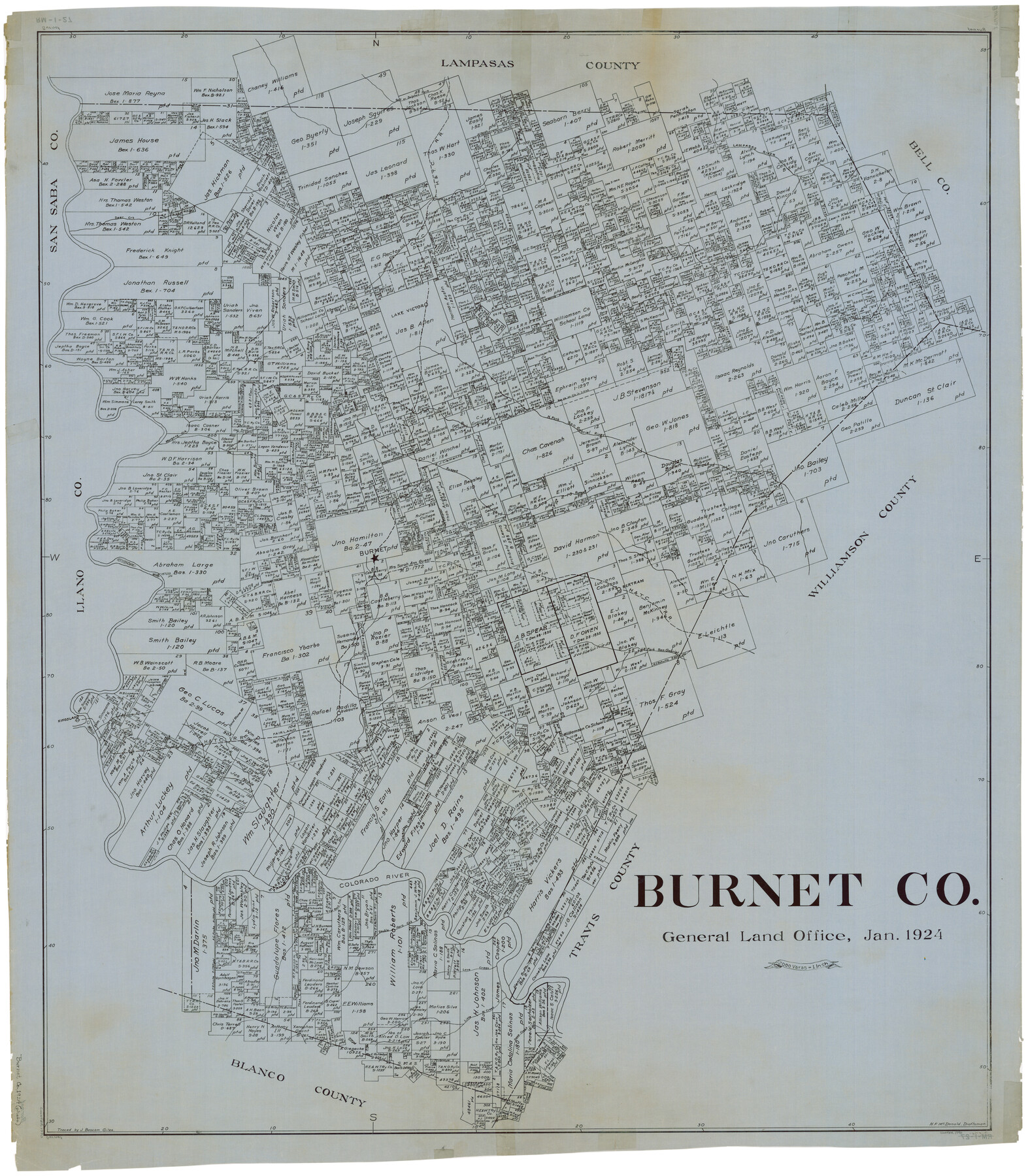
Burnet Co.
RM-1-27
-
Map/Doc
1790
-
Collection
General Map Collection
-
Object Dates
1/1924 (Creation Date)
-
People and Organizations
Texas General Land Office (Publisher)
H.F. McDonald (Draftsman)
H.F. McDonald (Compiler)
-
Counties
Burnet
-
Subjects
County
-
Height x Width
47.0 x 41.2 inches
119.4 x 104.7 cm
-
Comments
Traced by J. Bascom Giles.
Part of: General Map Collection
Real County Sketch File 16

Print $20.00
- Digital $50.00
Real County Sketch File 16
1934
Size 23.1 x 22.1 inches
Map/Doc 12234
[Surveyor's certificate by James Howlet, District Surveyor]
![318, [Surveyor's certificate by James Howlet, District Surveyor], General Map Collection](https://historictexasmaps.com/wmedia_w700/maps/318.tif.jpg)
Print $2.00
- Digital $50.00
[Surveyor's certificate by James Howlet, District Surveyor]
Size 6.1 x 8.0 inches
Map/Doc 318
Morris County Rolled Sketch 2A

Print $20.00
- Digital $50.00
Morris County Rolled Sketch 2A
Size 24.0 x 18.8 inches
Map/Doc 10237
Culberson County Working Sketch 23

Print $20.00
- Digital $50.00
Culberson County Working Sketch 23
1945
Size 38.3 x 44.7 inches
Map/Doc 68476
Edwards County Working Sketch 101

Print $20.00
- Digital $50.00
Edwards County Working Sketch 101
1971
Size 36.9 x 38.8 inches
Map/Doc 68977
Map of the Rio Grande & Eagle Pass Ry. from Sections 14-20 Inclusive, Webb County

Print $40.00
- Digital $50.00
Map of the Rio Grande & Eagle Pass Ry. from Sections 14-20 Inclusive, Webb County
1909
Size 25.3 x 55.6 inches
Map/Doc 64657
Llano County Working Sketch 1

Print $20.00
- Digital $50.00
Llano County Working Sketch 1
1938
Size 19.5 x 19.2 inches
Map/Doc 70619
Angelina County

Print $40.00
- Digital $50.00
Angelina County
1899
Size 38.9 x 49.9 inches
Map/Doc 4873
[Surveys on the Trinity River]
![342, [Surveys on the Trinity River], General Map Collection](https://historictexasmaps.com/wmedia_w700/maps/342.tif.jpg)
Print $2.00
- Digital $50.00
[Surveys on the Trinity River]
Size 6.6 x 4.6 inches
Map/Doc 342
Irion County Sketch File 7

Print $4.00
- Digital $50.00
Irion County Sketch File 7
1927
Size 11.1 x 7.1 inches
Map/Doc 27471
Liberty County Sketch File AX

Print $10.00
- Digital $50.00
Liberty County Sketch File AX
1899
Size 14.1 x 8.5 inches
Map/Doc 30061
Runnels County Working Sketch 32

Print $20.00
- Digital $50.00
Runnels County Working Sketch 32
1959
Size 27.7 x 24.0 inches
Map/Doc 63630
You may also like
[T. C. & S. F. Block K11, Capitol Leagues 367, 373, 374, and Blocks D and B]
![90542, [T. C. & S. F. Block K11, Capitol Leagues 367, 373, 374, and Blocks D and B], Twichell Survey Records](https://historictexasmaps.com/wmedia_w700/maps/90542-1.tif.jpg)
Print $3.00
- Digital $50.00
[T. C. & S. F. Block K11, Capitol Leagues 367, 373, 374, and Blocks D and B]
Size 9.8 x 13.5 inches
Map/Doc 90542
Controlled Mosaic by Jack Amman Photogrammetric Engineers, Inc - Sheet 48

Print $20.00
- Digital $50.00
Controlled Mosaic by Jack Amman Photogrammetric Engineers, Inc - Sheet 48
1954
Size 20.0 x 24.0 inches
Map/Doc 83507
Flight Mission No. DIX-8P, Frame 93, Aransas County

Print $20.00
- Digital $50.00
Flight Mission No. DIX-8P, Frame 93, Aransas County
1956
Size 18.5 x 22.3 inches
Map/Doc 83918
Bell County Working Sketch 2

Print $20.00
- Digital $50.00
Bell County Working Sketch 2
1938
Size 25.8 x 28.8 inches
Map/Doc 67342
Hudspeth County Working Sketch 50

Print $20.00
- Digital $50.00
Hudspeth County Working Sketch 50
Size 24.6 x 37.2 inches
Map/Doc 66335
Webb County Working Sketch 96

Print $20.00
- Digital $50.00
Webb County Working Sketch 96
1994
Size 36.1 x 36.3 inches
Map/Doc 72463
Jim Wells County Working Sketch Graphic Index

Print $20.00
- Digital $50.00
Jim Wells County Working Sketch Graphic Index
1966
Size 41.7 x 29.5 inches
Map/Doc 76597
Val Verde County Working Sketch 12

Print $20.00
- Digital $50.00
Val Verde County Working Sketch 12
1920
Size 29.0 x 24.3 inches
Map/Doc 72147
Motley County Sketch File 3 (N)

Print $22.00
- Digital $50.00
Motley County Sketch File 3 (N)
Size 9.1 x 13.0 inches
Map/Doc 31998
Nueces County Sketch File 12c

Print $11.00
- Digital $50.00
Nueces County Sketch File 12c
1889
Size 12.6 x 8.2 inches
Map/Doc 32534
Atascosa County Working Sketch 32

Print $20.00
- Digital $50.00
Atascosa County Working Sketch 32
1981
Size 12.9 x 11.8 inches
Map/Doc 67228
Travis County State Real Property Sketch 17

Print $20.00
- Digital $50.00
Travis County State Real Property Sketch 17
2012
Size 36.0 x 24.5 inches
Map/Doc 93354