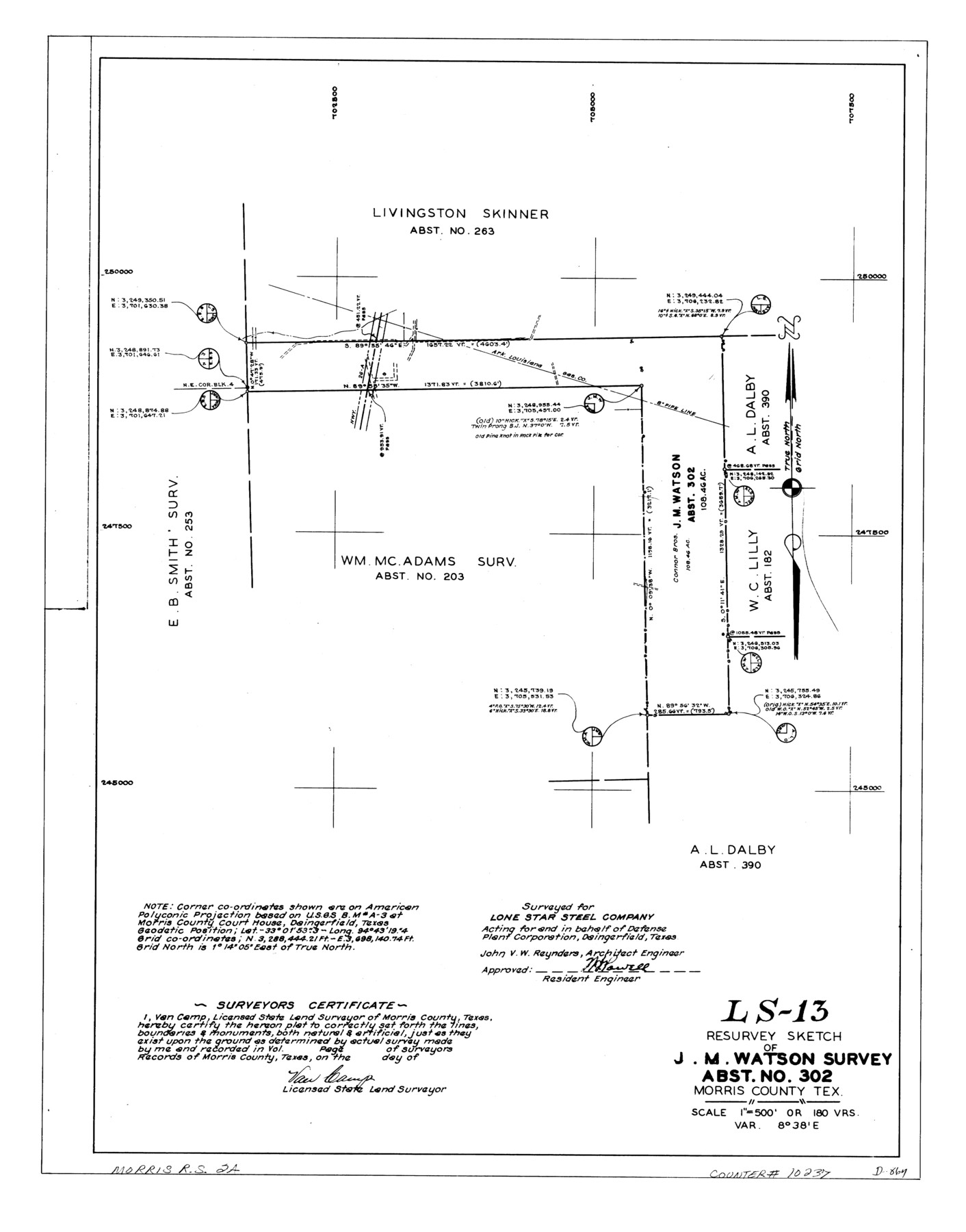
Morris County Rolled Sketch 2A
LS-13 - Resurvey sketch of J.M. Watson survey, abst. no. 302, Morris County, Tex.
-
Map/Doc
10237
-
Collection
General Map Collection
-
People and Organizations
Van Camp (Surveyor/Engineer)
-
Counties
Morris
-
Subjects
Surveying Rolled Sketch
-
Height x Width
24.0 x 18.8 inches
61.0 x 47.8 cm
-
Medium
linen, manuscript
-
Scale
1" = 180 varas
-
Comments
See Morris County Rolled Sketch 2 (9550) for map of all retracement surveys made for Lone Star Steel Company.
Related maps
Morris County Rolled Sketch 2

Print $40.00
- Digital $50.00
Morris County Rolled Sketch 2
1944
Size 59.4 x 43.5 inches
Map/Doc 9550
Part of: General Map Collection
Shackelford County Rolled Sketch 4A

Print $40.00
- Digital $50.00
Shackelford County Rolled Sketch 4A
1984
Size 35.2 x 48.7 inches
Map/Doc 9917
Jefferson County Sketch File 15

Print $10.00
- Digital $50.00
Jefferson County Sketch File 15
1870
Size 8.6 x 7.6 inches
Map/Doc 28151
Aransas County Rolled Sketch 27E

Print $20.00
- Digital $50.00
Aransas County Rolled Sketch 27E
1958
Size 30.2 x 30.9 inches
Map/Doc 8419
Hansford County Boundary File 3a

Print $80.00
- Digital $50.00
Hansford County Boundary File 3a
Size 15.3 x 64.7 inches
Map/Doc 54275
Coleman County Boundary File 17 (1)

Print $52.00
- Digital $50.00
Coleman County Boundary File 17 (1)
Size 7.7 x 3.9 inches
Map/Doc 51628
Brewster County Working Sketch 10

Print $20.00
- Digital $50.00
Brewster County Working Sketch 10
1910
Size 17.8 x 16.8 inches
Map/Doc 67543
Val Verde County Sketch File XXX8

Print $6.00
- Digital $50.00
Val Verde County Sketch File XXX8
Size 9.0 x 16.4 inches
Map/Doc 39106
Morris County Rolled Sketch 2A

Print $20.00
- Digital $50.00
Morris County Rolled Sketch 2A
Size 24.2 x 19.1 inches
Map/Doc 10267

McMullen County
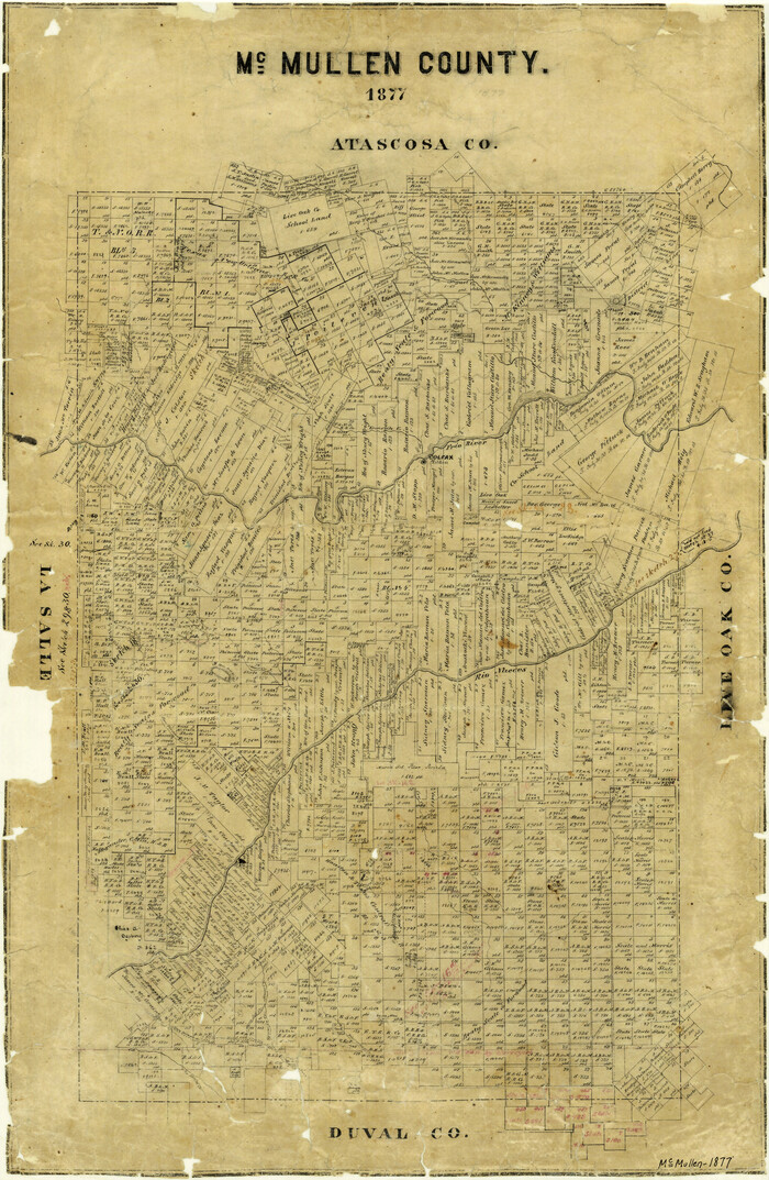
Print $20.00
- Digital $50.00
McMullen County
1877
Size 26.1 x 17.2 inches
Map/Doc 3867
Hudspeth County Rolled Sketch 28

Print $40.00
- Digital $50.00
Hudspeth County Rolled Sketch 28
Size 31.5 x 49.8 inches
Map/Doc 9208
Hardin County Working Sketch 4

Print $3.00
- Digital $50.00
Hardin County Working Sketch 4
1906
Size 11.0 x 16.8 inches
Map/Doc 63402
You may also like
Edwards County Rolled Sketch N

Print $20.00
- Digital $50.00
Edwards County Rolled Sketch N
1934
Size 18.9 x 23.7 inches
Map/Doc 6066
Cottle County Working Sketch 21

Print $20.00
- Digital $50.00
Cottle County Working Sketch 21
1982
Size 37.0 x 46.6 inches
Map/Doc 68331
[Sketch for Mineral Application 33721 - 33725 Incl. - Padre and Mustang Island]
![2876, [Sketch for Mineral Application 33721 - 33725 Incl. - Padre and Mustang Island], General Map Collection](https://historictexasmaps.com/wmedia_w700/maps/2876.tif.jpg)
Print $20.00
- Digital $50.00
[Sketch for Mineral Application 33721 - 33725 Incl. - Padre and Mustang Island]
1942
Size 29.1 x 23.0 inches
Map/Doc 2876
Wm. H. Bush Estate resurveyed by W. D. Twichell May 1905

Print $40.00
- Digital $50.00
Wm. H. Bush Estate resurveyed by W. D. Twichell May 1905
1905
Size 36.2 x 57.1 inches
Map/Doc 89784

Comanche County Working Sketch 24

Print $20.00
- Digital $50.00
Comanche County Working Sketch 24
1975
Size 29.8 x 33.4 inches
Map/Doc 68158

Pecos County Working Sketch 12

Print $20.00
- Digital $50.00
Pecos County Working Sketch 12
1912
Size 21.3 x 30.0 inches
Map/Doc 71482
Montague County Working Sketch 38

Print $20.00
- Digital $50.00
Montague County Working Sketch 38
1990
Size 14.9 x 15.6 inches
Map/Doc 71104
[Tom Green County]
![82060, [Tom Green County], General Map Collection](https://historictexasmaps.com/wmedia_w700/maps/82060.tif.jpg)
Print $40.00
- Digital $50.00
[Tom Green County]
1888
Size 45.8 x 113.0 inches
Map/Doc 82060
Nueces County Sketch File 23

Print $36.00
- Digital $50.00
Nueces County Sketch File 23
1886
Size 11.2 x 8.6 inches
Map/Doc 32563
Hudspeth County Sketch File 9

Print $8.00
- Digital $50.00
Hudspeth County Sketch File 9
1900
Size 11.3 x 8.8 inches
Map/Doc 26895