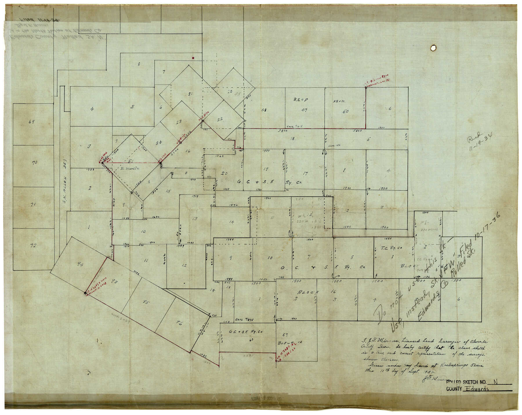
Edwards County Rolled Sketch N
[Sketch of the area around Block 16, G. C. & S. F. Ry. Co.]
-
Map/Doc
6066
-
Collection
General Map Collection
-
Object Dates
9/11/1934 (Creation Date)
11/19/1934 (File Date)
-
People and Organizations
J.F. Winans (Surveyor/Engineer)
-
Counties
Edwards
-
Subjects
Surveying Rolled Sketch
-
Height x Width
18.9 x 23.7 inches
48.0 x 60.2 cm
-
Medium
linen, manuscript
-
Comments
Note on map: "Do not use this sketch. See Brewster County Rolled Sketch JFW (8843) instead."
Related maps
Edwards County Rolled Sketch JFW

Print $20.00
- Digital $50.00
Edwards County Rolled Sketch JFW
1936
Size 39.5 x 39.4 inches
Map/Doc 8843
Part of: General Map Collection
Jefferson County Working Sketch 17

Print $20.00
- Digital $50.00
Jefferson County Working Sketch 17
1954
Size 47.1 x 30.3 inches
Map/Doc 66560
Hudspeth County Sketch File 12

Print $10.00
- Digital $50.00
Hudspeth County Sketch File 12
1901
Size 14.2 x 8.7 inches
Map/Doc 26924
Sutton County Boundary File 3

Print $22.00
- Digital $50.00
Sutton County Boundary File 3
Size 14.2 x 8.7 inches
Map/Doc 59024
Presidio County Sketch File 48

Print $6.00
- Digital $50.00
Presidio County Sketch File 48
1918
Size 15.1 x 11.0 inches
Map/Doc 34582
Dimmit County Rolled Sketch 5

Print $20.00
- Digital $50.00
Dimmit County Rolled Sketch 5
1904
Size 42.7 x 18.2 inches
Map/Doc 5715
Jack County Working Sketch 21

Print $20.00
- Digital $50.00
Jack County Working Sketch 21
1993
Size 28.3 x 40.0 inches
Map/Doc 66447
Montague County Sketch File 21

Print $4.00
- Digital $50.00
Montague County Sketch File 21
1888
Size 12.4 x 8.3 inches
Map/Doc 31751
Morris County Rolled Sketch 2A

Print $20.00
- Digital $50.00
Morris County Rolled Sketch 2A
Size 24.3 x 18.7 inches
Map/Doc 10675
Jim Hogg County Working Sketch 7

Print $20.00
- Digital $50.00
Jim Hogg County Working Sketch 7
1964
Size 20.0 x 18.6 inches
Map/Doc 66593
Hale County Rolled Sketch 10

Print $40.00
- Digital $50.00
Hale County Rolled Sketch 10
Size 52.4 x 28.3 inches
Map/Doc 76447
Jackson County Sketch File 13

Print $40.00
- Digital $50.00
Jackson County Sketch File 13
Size 29.0 x 18.6 inches
Map/Doc 11839
Right-of-Way & Track Map, Houston and Brazos Valley Ry. Co. operated by the Houston and Brazos Valley Ry. Co.

Print $40.00
- Digital $50.00
Right-of-Way & Track Map, Houston and Brazos Valley Ry. Co. operated by the Houston and Brazos Valley Ry. Co.
1918
Size 25.0 x 55.7 inches
Map/Doc 64605
You may also like
Flight Mission No. BRE-3P, Frame 35, Nueces County

Print $20.00
- Digital $50.00
Flight Mission No. BRE-3P, Frame 35, Nueces County
1956
Size 18.5 x 21.1 inches
Map/Doc 86813
Flight Mission No. DQN-3K, Frame 67, Calhoun County

Print $20.00
- Digital $50.00
Flight Mission No. DQN-3K, Frame 67, Calhoun County
1953
Size 18.6 x 22.3 inches
Map/Doc 84358
El Paso County Working Sketch 53

Print $20.00
- Digital $50.00
El Paso County Working Sketch 53
1992
Size 22.8 x 28.9 inches
Map/Doc 69075
Flight Mission No. DIX-6P, Frame 131, Aransas County

Print $20.00
- Digital $50.00
Flight Mission No. DIX-6P, Frame 131, Aransas County
1956
Size 19.5 x 23.0 inches
Map/Doc 83837
PSL Field Notes for Blocks B13, B18, and B28 in Crane and Ward Counties, and Blocks B19, B20, and B29 in Ward County

PSL Field Notes for Blocks B13, B18, and B28 in Crane and Ward Counties, and Blocks B19, B20, and B29 in Ward County
Map/Doc 81647
Reagan County Sketch File 29

Print $20.00
- Digital $50.00
Reagan County Sketch File 29
1951
Size 21.3 x 30.5 inches
Map/Doc 12225
Limestone County Working Sketch 28

Print $20.00
- Digital $50.00
Limestone County Working Sketch 28
2008
Size 30.2 x 29.1 inches
Map/Doc 88848
Flight Mission No. DAG-17K, Frame 140, Matagorda County

Print $20.00
- Digital $50.00
Flight Mission No. DAG-17K, Frame 140, Matagorda County
1952
Size 16.5 x 16.1 inches
Map/Doc 86357
[Section 2, Block 5, Dawson County, Texas]
![92617, [Section 2, Block 5, Dawson County, Texas], Twichell Survey Records](https://historictexasmaps.com/wmedia_w700/maps/92617-1.tif.jpg)
Print $2.00
- Digital $50.00
[Section 2, Block 5, Dawson County, Texas]
Size 9.2 x 12.3 inches
Map/Doc 92617
[Morris County School Land and vicinity]
![90360, [Morris County School Land and vicinity], Twichell Survey Records](https://historictexasmaps.com/wmedia_w700/maps/90360-1.tif.jpg)
Print $20.00
- Digital $50.00
[Morris County School Land and vicinity]
Size 14.2 x 13.0 inches
Map/Doc 90360
Briscoe County Rolled Sketch 11

Print $20.00
- Digital $50.00
Briscoe County Rolled Sketch 11
1913
Size 25.0 x 21.6 inches
Map/Doc 5328
Zapata County Working Sketch 16

Print $20.00
- Digital $50.00
Zapata County Working Sketch 16
1969
Size 26.1 x 28.3 inches
Map/Doc 62067