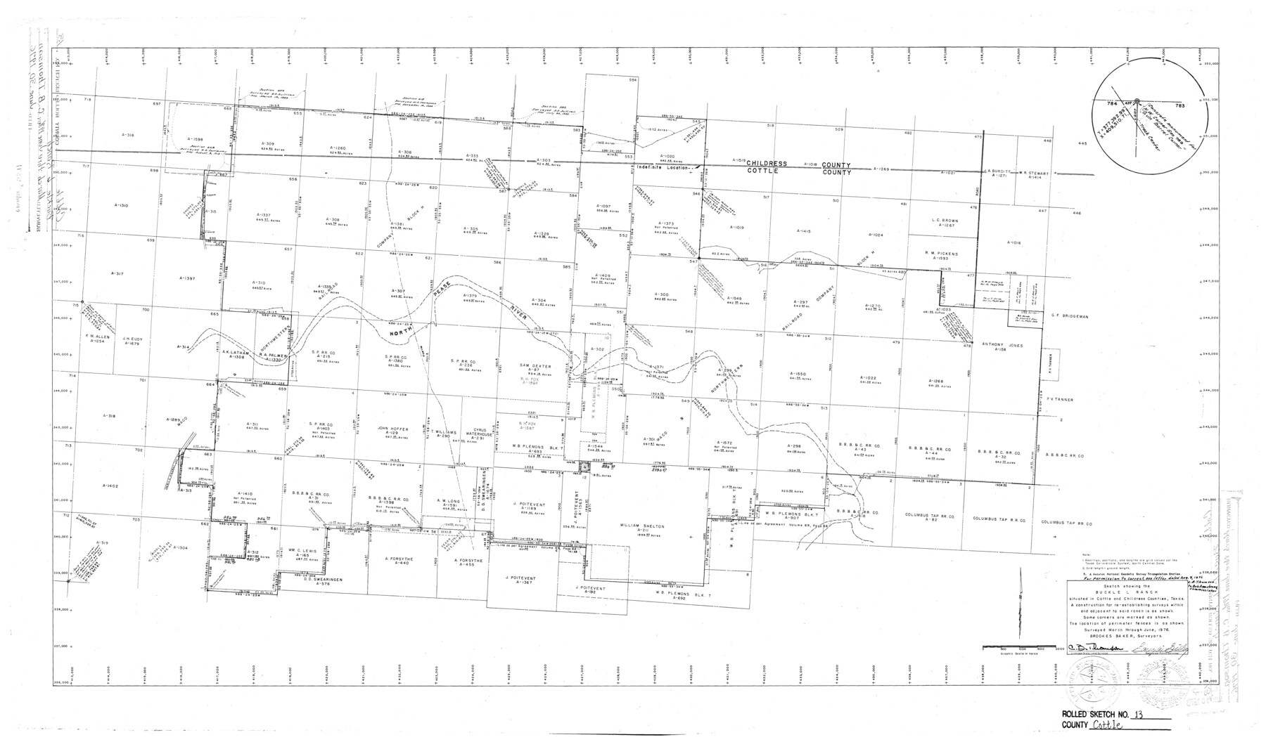
Cottle County Rolled Sketch 13
Sketch showing the Buckle L Ranch situated in Cottle and Childress Counties, Texas
-
Map/Doc
5571
-
Collection
General Map Collection
-
Object Dates
6/1976 (Creation Date)
6/30/1976 (File Date)
-
People and Organizations
C.B. Thomson (Surveyor/Engineer)
Garey W. Gilley (Surveyor/Engineer)
-
Counties
Cottle Childress
-
Subjects
Surveying Rolled Sketch
-
Height x Width
21.6 x 35.5 inches
54.9 x 90.2 cm
Part of: General Map Collection
Grimes County Working Sketch 5

Print $40.00
- Digital $50.00
Grimes County Working Sketch 5
1949
Size 43.6 x 83.2 inches
Map/Doc 63296
Randall County Boundary File 3

Print $8.00
- Digital $50.00
Randall County Boundary File 3
Size 14.3 x 8.8 inches
Map/Doc 58125
McMullen County Working Sketch 28

Print $20.00
- Digital $50.00
McMullen County Working Sketch 28
1954
Size 25.6 x 22.4 inches
Map/Doc 70729
Live Oak County Working Sketch 11

Print $20.00
- Digital $50.00
Live Oak County Working Sketch 11
1949
Size 29.7 x 25.7 inches
Map/Doc 70596
Kerr County Working Sketch 5

Print $20.00
- Digital $50.00
Kerr County Working Sketch 5
1947
Size 21.9 x 19.8 inches
Map/Doc 70036
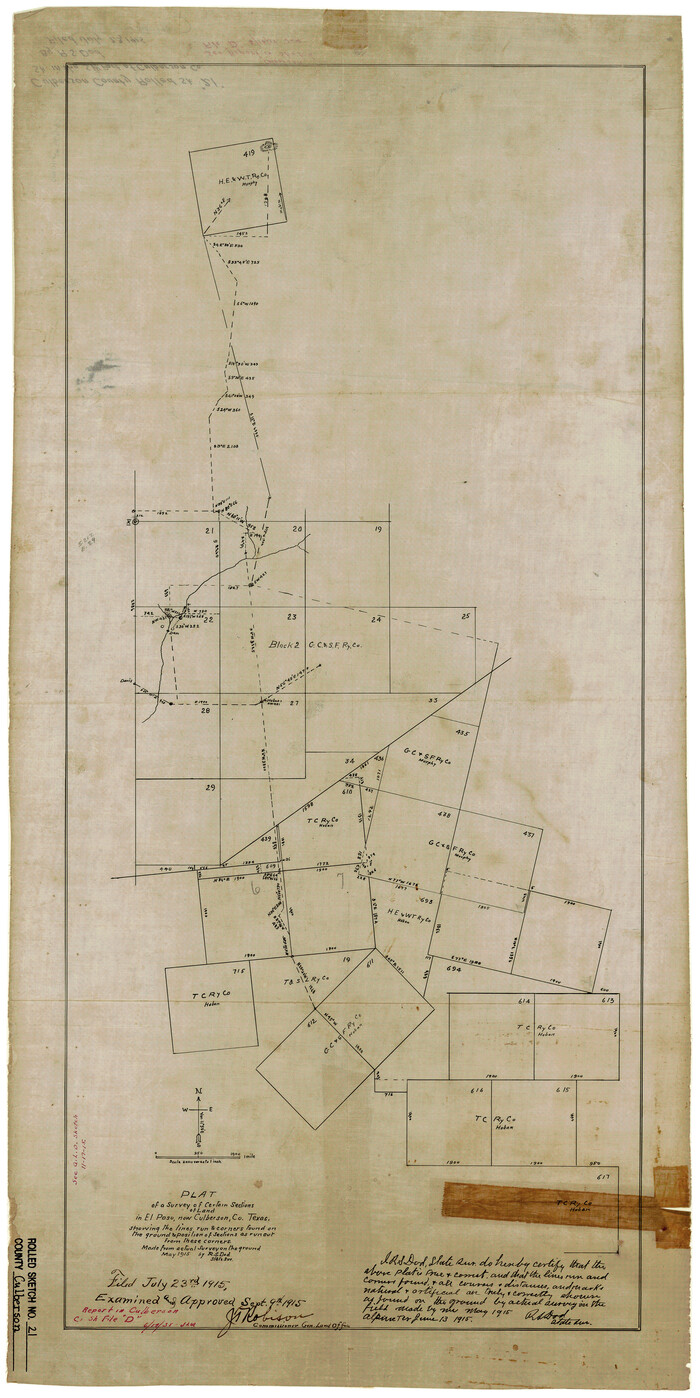
Culberson County Rolled Sketch 21
Print $20.00
- Digital $50.00
Culberson County Rolled Sketch 21
1915
Size 31.2 x 15.6 inches
Map/Doc 5654
Laguna Madre, T-9212

Print $20.00
- Digital $50.00
Laguna Madre, T-9212
Size 33.1 x 31.4 inches
Map/Doc 73603
Flight Mission No. CRE-1R, Frame 120, Jackson County

Print $20.00
- Digital $50.00
Flight Mission No. CRE-1R, Frame 120, Jackson County
1956
Size 16.1 x 15.9 inches
Map/Doc 85331
Liberty County Working Sketch 81

Print $20.00
- Digital $50.00
Liberty County Working Sketch 81
1981
Size 8.0 x 24.2 inches
Map/Doc 70541
Newton County Sketch File 20

Print $4.00
- Digital $50.00
Newton County Sketch File 20
1893
Size 14.2 x 8.7 inches
Map/Doc 32395
Real County Working Sketch 51

Print $20.00
- Digital $50.00
Real County Working Sketch 51
1957
Size 28.1 x 24.1 inches
Map/Doc 71943
Harris County Rolled Sketch 66

Print $40.00
- Digital $50.00
Harris County Rolled Sketch 66
1940
Size 36.7 x 51.4 inches
Map/Doc 9129
You may also like
Real County Sketch File 7

Print $8.00
- Digital $50.00
Real County Sketch File 7
1931
Size 11.3 x 8.8 inches
Map/Doc 35055
Kleberg County Rolled Sketch 8

Print $20.00
- Digital $50.00
Kleberg County Rolled Sketch 8
1947
Size 33.0 x 42.0 inches
Map/Doc 9360
Carte de la Louisiane et Pays Voisins Pour servir a l'Histoire Generale des Voyages

Print $20.00
Carte de la Louisiane et Pays Voisins Pour servir a l'Histoire Generale des Voyages
1757
Size 9.6 x 14.9 inches
Map/Doc 94572
Encinal County

Print $20.00
- Digital $50.00
Encinal County
1886
Size 32.7 x 22.4 inches
Map/Doc 3515
Freestone County Sketch File 23

Print $6.00
- Digital $50.00
Freestone County Sketch File 23
1918
Size 11.4 x 8.9 inches
Map/Doc 23084
Robertson County Working Sketch 21

Print $20.00
- Digital $50.00
Robertson County Working Sketch 21
2006
Size 44.0 x 33.1 inches
Map/Doc 84701
Henderson County Rolled Sketch 11

Print $20.00
- Digital $50.00
Henderson County Rolled Sketch 11
1915
Size 29.1 x 42.4 inches
Map/Doc 75948
Hudspeth County Sketch File 9

Print $8.00
- Digital $50.00
Hudspeth County Sketch File 9
1900
Size 11.3 x 8.8 inches
Map/Doc 26895
Houston Ship Channel, Alexander Island to Carpenter Bayou

Print $40.00
- Digital $50.00
Houston Ship Channel, Alexander Island to Carpenter Bayou
1989
Size 35.5 x 49.4 inches
Map/Doc 69916
Flight Mission No. DAG-23K, Frame 18, Matagorda County

Print $20.00
- Digital $50.00
Flight Mission No. DAG-23K, Frame 18, Matagorda County
1953
Size 18.5 x 22.2 inches
Map/Doc 86480
McCulloch County Working Sketch 9

Print $20.00
- Digital $50.00
McCulloch County Working Sketch 9
1978
Size 35.6 x 32.7 inches
Map/Doc 70684
[County Line between DeWitt and Lavaca Counties]
![65355, [County Line between DeWitt and Lavaca Counties], General Map Collection](https://historictexasmaps.com/wmedia_w700/pdf_converted_jpg/qi_pdf_thumbnail_19782.jpg)
Print $226.00
- Digital $50.00
[County Line between DeWitt and Lavaca Counties]
1906
Size 17.4 x 34.4 inches
Map/Doc 65355