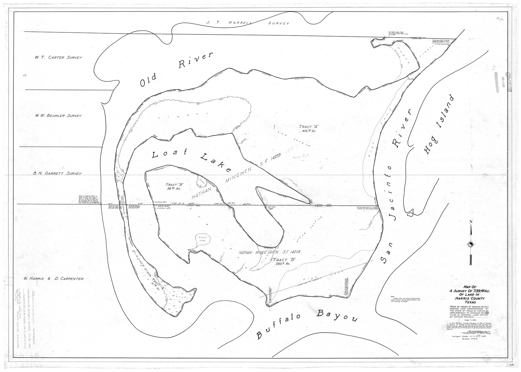
Harris County Rolled Sketch 66
Map of a survey of 739.42 ac. of land in Harris County, Texas
-
Map/Doc
9129
-
Collection
General Map Collection
-
Object Dates
10/20/1940 (Creation Date)
12/5/1940 (File Date)
-
People and Organizations
A.C. Stimson (Surveyor/Engineer)
-
Counties
Harris
-
Subjects
Surveying Rolled Sketch
-
Height x Width
36.7 x 51.4 inches
93.2 x 130.6 cm
-
Scale
1" = 100 varas
Part of: General Map Collection
Sutton County

Print $40.00
- Digital $50.00
Sutton County
1898
Size 39.1 x 56.5 inches
Map/Doc 63051
Map of Fort Bend County

Print $20.00
- Digital $50.00
Map of Fort Bend County
1839
Size 19.0 x 26.9 inches
Map/Doc 3549
Brazoria County Sketch File 15b

Print $40.00
- Digital $50.00
Brazoria County Sketch File 15b
Size 13.2 x 26.3 inches
Map/Doc 10951
Briscoe County

Print $20.00
- Digital $50.00
Briscoe County
1881
Size 26.8 x 21.5 inches
Map/Doc 3333
Wood County Rolled Sketch 5

Print $20.00
- Digital $50.00
Wood County Rolled Sketch 5
1950
Size 36.8 x 40.2 inches
Map/Doc 10161
Crockett County Working Sketch 69

Print $20.00
- Digital $50.00
Crockett County Working Sketch 69
1962
Size 34.8 x 45.5 inches
Map/Doc 68402
Blanco County Sketch File 2

Print $5.00
- Digital $50.00
Blanco County Sketch File 2
Size 10.3 x 8.5 inches
Map/Doc 14580
Chambers County Rolled Sketch 23

Print $40.00
- Digital $50.00
Chambers County Rolled Sketch 23
1940
Size 36.5 x 49.2 inches
Map/Doc 8591
Angelina County Sketch File 16a

Print $62.00
- Digital $50.00
Angelina County Sketch File 16a
1862
Size 6.0 x 8.3 inches
Map/Doc 13009
Freestone County Working Sketch 11

Print $40.00
- Digital $50.00
Freestone County Working Sketch 11
1978
Size 31.4 x 51.4 inches
Map/Doc 69253
Live Oak County Boundary File 60a

Print $18.00
- Digital $50.00
Live Oak County Boundary File 60a
Size 12.7 x 8.4 inches
Map/Doc 56407
Tyler County Sketch File 2

Print $4.00
- Digital $50.00
Tyler County Sketch File 2
Size 6.3 x 5.6 inches
Map/Doc 38615
You may also like
Plat of Section No. 44, Blk. No. 4, T. & P. RR. Co. showing subdivisions of same with 3.1 acre survey made for W. D. Twichell

Print $2.00
- Digital $50.00
Plat of Section No. 44, Blk. No. 4, T. & P. RR. Co. showing subdivisions of same with 3.1 acre survey made for W. D. Twichell
1919
Size 8.9 x 13.3 inches
Map/Doc 91908
Cooke County Boundary File 1b

Print $28.00
- Digital $50.00
Cooke County Boundary File 1b
Size 12.6 x 7.4 inches
Map/Doc 51835
Desdemona Oil Pool

Print $20.00
- Digital $50.00
Desdemona Oil Pool
Size 38.7 x 43.1 inches
Map/Doc 89773
Map of Anderson County

Print $20.00
- Digital $50.00
Map of Anderson County
1895
Size 46.7 x 37.5 inches
Map/Doc 4866
San Augustine County, Texas

Print $20.00
- Digital $50.00
San Augustine County, Texas
1879
Size 22.7 x 17.5 inches
Map/Doc 752
Haskell County Sketch File 5

Print $4.00
- Digital $50.00
Haskell County Sketch File 5
1856
Size 10.1 x 8.1 inches
Map/Doc 26124
Chart of the Antarctic Continent shewing the icy barrier attached to it discovered by the U.S. Ex. Ex.

Print $20.00
- Digital $50.00
Chart of the Antarctic Continent shewing the icy barrier attached to it discovered by the U.S. Ex. Ex.
1840
Size 26.5 x 37.2 inches
Map/Doc 94058
[Map showing resurvey of Capitol Leagues in Hartley & Oldham Counties, Texas]
![1754, [Map showing resurvey of Capitol Leagues in Hartley & Oldham Counties, Texas], General Map Collection](https://historictexasmaps.com/wmedia_w700/maps/1754-1.tif.jpg)
Print $20.00
- Digital $50.00
[Map showing resurvey of Capitol Leagues in Hartley & Oldham Counties, Texas]
1918
Size 30.8 x 37.4 inches
Map/Doc 1754
Sabine County

Print $20.00
- Digital $50.00
Sabine County
1920
Size 41.2 x 31.8 inches
Map/Doc 77413
Runnels County Rolled Sketch 1

Print $20.00
- Digital $50.00
Runnels County Rolled Sketch 1
1854
Size 28.0 x 18.4 inches
Map/Doc 75941
Crane County Working Sketch 24

Print $20.00
- Digital $50.00
Crane County Working Sketch 24
1966
Size 28.7 x 33.3 inches
Map/Doc 68301
Lampasas County Sketch File X

Print $40.00
- Digital $50.00
Lampasas County Sketch File X
1909
Size 13.2 x 17.4 inches
Map/Doc 29386