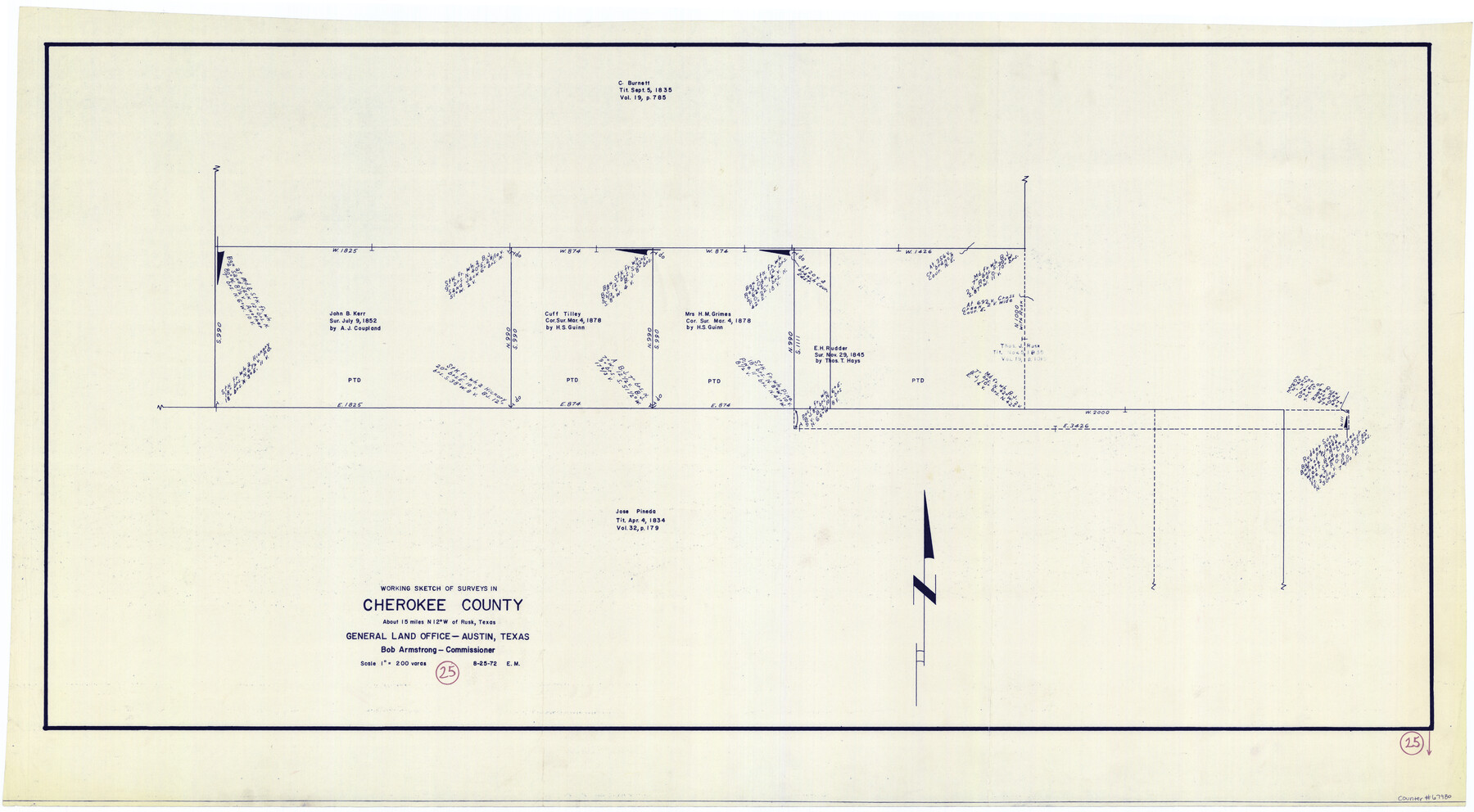
Cherokee County Working Sketch 25
-
Map/Doc
67980
-
Collection
General Map Collection
-
Object Dates
8/25/1972 (Creation Date)
-
Counties
Cherokee
-
Subjects
Surveying Working Sketch
-
Height x Width
25.1 x 45.5 inches
63.8 x 115.6 cm
-
Scale
1" = 200 varas
Part of: General Map Collection
Nueces County Rolled Sketch 32

Print $20.00
- Digital $50.00
Nueces County Rolled Sketch 32
Size 17.0 x 17.2 inches
Map/Doc 6876
Walker County Sketch File 5

Print $4.00
- Digital $50.00
Walker County Sketch File 5
Size 13.5 x 8.3 inches
Map/Doc 39555
Harris County Historic Topographic 24

Print $20.00
- Digital $50.00
Harris County Historic Topographic 24
1916
Size 29.2 x 22.9 inches
Map/Doc 65835
Brazoria County NRC Article 33.136 Sketch 17

Print $88.00
- Digital $50.00
Brazoria County NRC Article 33.136 Sketch 17
2015
Size 22.0 x 34.0 inches
Map/Doc 95020
Gaines County

Print $20.00
- Digital $50.00
Gaines County
1956
Size 32.2 x 40.6 inches
Map/Doc 77286
Baylor County Sketch File 12C

Print $8.00
- Digital $50.00
Baylor County Sketch File 12C
1900
Size 13.5 x 8.8 inches
Map/Doc 14155
Harris County Rolled Sketch 33

Print $20.00
- Digital $50.00
Harris County Rolled Sketch 33
1912
Size 26.0 x 34.5 inches
Map/Doc 6097
Presidio County Sketch File 46

Print $8.00
- Digital $50.00
Presidio County Sketch File 46
1915
Size 10.2 x 8.3 inches
Map/Doc 34535

Edwards County Working Sketch 1

Print $20.00
- Digital $50.00
Edwards County Working Sketch 1
Size 12.2 x 16.4 inches
Map/Doc 68877
Williamson County Sketch File 3

Print $24.00
- Digital $50.00
Williamson County Sketch File 3
1853
Size 13.0 x 8.2 inches
Map/Doc 40301
Newton County Working Sketch 29

Print $20.00
- Digital $50.00
Newton County Working Sketch 29
1955
Size 21.2 x 39.8 inches
Map/Doc 71275
You may also like
Hansford County School Land

Print $20.00
- Digital $50.00
Hansford County School Land
1892
Size 33.3 x 20.7 inches
Map/Doc 92512

Montgomery County Rolled Sketch 19

Print $40.00
- Digital $50.00
Montgomery County Rolled Sketch 19
1933
Size 50.6 x 30.7 inches
Map/Doc 9529
Hopkins County Sketch File 12

Print $6.00
- Digital $50.00
Hopkins County Sketch File 12
Size 6.8 x 8.1 inches
Map/Doc 26706
Terrell County Sketch File 29

Print $6.00
- Digital $50.00
Terrell County Sketch File 29
1940
Size 11.2 x 8.8 inches
Map/Doc 37976
Mills County Rolled Sketch 7

Print $20.00
- Digital $50.00
Mills County Rolled Sketch 7
2025
Size 23.7 x 29.8 inches
Map/Doc 97434
Bell County Sketch File 36

Print $12.00
- Digital $50.00
Bell County Sketch File 36
1839
Size 6.8 x 8.4 inches
Map/Doc 14457
Chambers County Sketch File 21a

Print $2.00
- Digital $50.00
Chambers County Sketch File 21a
1867
Size 10.2 x 6.6 inches
Map/Doc 17593
Map of Surveys on Harbor Island

Print $40.00
- Digital $50.00
Map of Surveys on Harbor Island
1912
Size 57.3 x 42.2 inches
Map/Doc 594
Flight Mission No. DAH-10M, Frame 45, Orange County

Print $20.00
- Digital $50.00
Flight Mission No. DAH-10M, Frame 45, Orange County
1953
Size 18.8 x 22.5 inches
Map/Doc 86880
Lampasas County Boundary File Index

Print $2.00
- Digital $50.00
Lampasas County Boundary File Index
Size 9.0 x 9.6 inches
Map/Doc 56092
McMullen County

Print $40.00
- Digital $50.00
McMullen County
1967
Size 49.7 x 34.8 inches
Map/Doc 73236