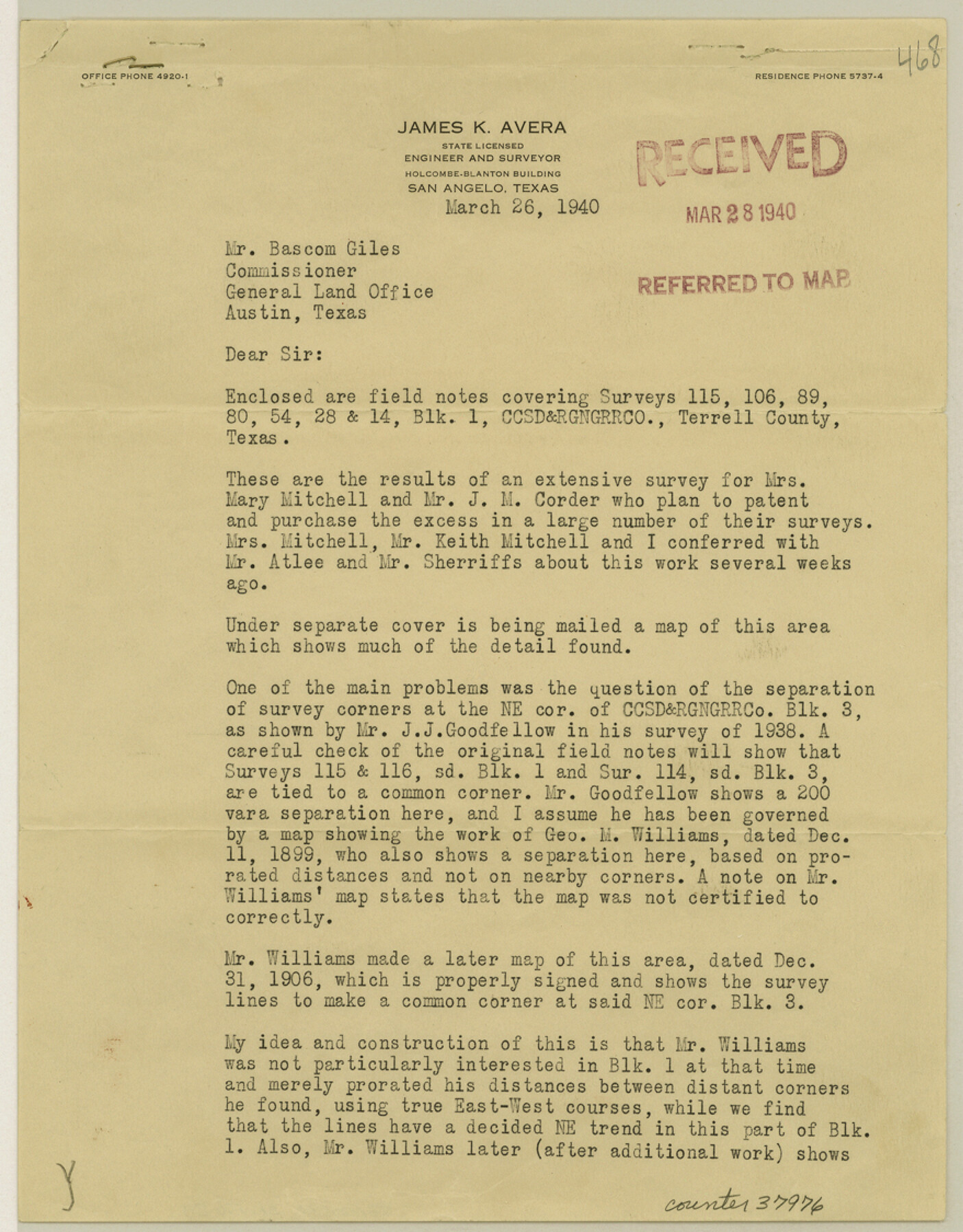
Terrell County Sketch File 29
[Explanation of report regarding surveys in Block 1, C. C. S. D. & R.G.N. G. R.R. Co. from James K. Avera]
-
Map/Doc
37976
-
Collection
General Map Collection
-
Object Dates
3/26/1940 (Creation Date)
3/28/1940 (File Date)
-
People and Organizations
James K. Avera (Surveyor/Engineer)
-
Counties
Terrell
-
Subjects
Surveying Sketch File
-
Height x Width
11.2 x 8.8 inches
28.5 x 22.4 cm
-
Medium
paper, print
-
Comments
See Terrell County Rolled Sketch 36 (9989) for sketch.
Related maps
Terrell County Rolled Sketch 36

Print $20.00
- Digital $50.00
Terrell County Rolled Sketch 36
1940
Size 17.4 x 33.8 inches
Map/Doc 9989
Part of: General Map Collection
Jack County Boundary File 3b

Print $23.00
- Digital $50.00
Jack County Boundary File 3b
Size 15.6 x 38.4 inches
Map/Doc 55418
Flight Mission No. DIX-5P, Frame 152, Aransas County

Print $20.00
- Digital $50.00
Flight Mission No. DIX-5P, Frame 152, Aransas County
1956
Size 17.8 x 18.6 inches
Map/Doc 83814
Central Part of Jeff Davis Co.

Print $40.00
- Digital $50.00
Central Part of Jeff Davis Co.
1982
Size 56.3 x 43.9 inches
Map/Doc 95543
Roberts County Sketch File 4

Print $12.00
- Digital $50.00
Roberts County Sketch File 4
1889
Size 8.7 x 7.8 inches
Map/Doc 35306
[Sketch for Mineral Application 16696-16697, Pecos River]
![65613, [Sketch for Mineral Application 16696-16697, Pecos River], General Map Collection](https://historictexasmaps.com/wmedia_w700/maps/65613-1.tif.jpg)
Print $40.00
- Digital $50.00
[Sketch for Mineral Application 16696-16697, Pecos River]
Size 36.7 x 68.3 inches
Map/Doc 65613
Gonzales County Working Sketch 5

Print $20.00
- Digital $50.00
Gonzales County Working Sketch 5
1980
Size 31.2 x 43.6 inches
Map/Doc 63221
Map of Travis Co.

Print $40.00
- Digital $50.00
Map of Travis Co.
1850
Size 37.2 x 50.8 inches
Map/Doc 78387
Burnet County Boundary File 8

Print $88.00
- Digital $50.00
Burnet County Boundary File 8
Size 8.7 x 32.2 inches
Map/Doc 50908
Maps of Gulf Intracoastal Waterway, Texas - Sabine River to the Rio Grande and connecting waterways including ship channels

Print $20.00
- Digital $50.00
Maps of Gulf Intracoastal Waterway, Texas - Sabine River to the Rio Grande and connecting waterways including ship channels
1966
Size 14.5 x 22.3 inches
Map/Doc 61949
Jackson County Working Sketch 14

Print $20.00
- Digital $50.00
Jackson County Working Sketch 14
1990
Size 31.7 x 32.2 inches
Map/Doc 66462
Fisher County Sketch File A and A1

Print $8.00
- Digital $50.00
Fisher County Sketch File A and A1
1901
Size 14.4 x 9.2 inches
Map/Doc 22583
[Sketch for Mineral Application 1112 - Colorado River, H. E. Chambers]
![65636, [Sketch for Mineral Application 1112 - Colorado River, H. E. Chambers], General Map Collection](https://historictexasmaps.com/wmedia_w700/maps/65636.tif.jpg)
Print $40.00
- Digital $50.00
[Sketch for Mineral Application 1112 - Colorado River, H. E. Chambers]
1918
Size 48.2 x 26.5 inches
Map/Doc 65636
You may also like
San Jacinto County Working Sketch 28

Print $20.00
- Digital $50.00
San Jacinto County Working Sketch 28
1945
Size 32.6 x 26.5 inches
Map/Doc 63741
Castro County Sketch File 4a

Print $4.00
- Digital $50.00
Castro County Sketch File 4a
Size 6.2 x 8.5 inches
Map/Doc 17465
Pecos County Rolled Sketch 100

Print $20.00
- Digital $50.00
Pecos County Rolled Sketch 100
1936
Size 45.2 x 25.2 inches
Map/Doc 9712
Leagues 218, 220, 238- 241, 226- 229]
![91066, Leagues 218, 220, 238- 241, 226- 229], Twichell Survey Records](https://historictexasmaps.com/wmedia_w700/maps/91066-1.tif.jpg)
Print $20.00
- Digital $50.00
Leagues 218, 220, 238- 241, 226- 229]
Size 10.3 x 33.7 inches
Map/Doc 91066
Tyler County Working Sketch 1

Print $20.00
- Digital $50.00
Tyler County Working Sketch 1
1911
Size 19.0 x 15.0 inches
Map/Doc 69471
Roberts County Working Sketch 30

Print $20.00
- Digital $50.00
Roberts County Working Sketch 30
1983
Size 47.4 x 38.5 inches
Map/Doc 63556
Louisiana and Texas Intracoastal Waterway, Section 7, Galveston Bay to Brazos River and Section 8, Brazos River to Matagorda Bay

Print $20.00
- Digital $50.00
Louisiana and Texas Intracoastal Waterway, Section 7, Galveston Bay to Brazos River and Section 8, Brazos River to Matagorda Bay
1928
Size 30.8 x 42.9 inches
Map/Doc 61839
Padre Island National Seashore

Print $4.00
- Digital $50.00
Padre Island National Seashore
Size 16.0 x 22.3 inches
Map/Doc 60532
Hudspeth County Rolled Sketch 72

Print $40.00
- Digital $50.00
Hudspeth County Rolled Sketch 72
1992
Size 36.7 x 49.0 inches
Map/Doc 9235
Rusk County Sketch File 27a

Print $10.00
Rusk County Sketch File 27a
1936
Size 14.2 x 8.8 inches
Map/Doc 35532
[Block 6T, Portions of Blocks 44, 2T, and 3T, and vicinity]
![91526, [Block 6T, Portions of Blocks 44, 2T, and 3T, and vicinity], Twichell Survey Records](https://historictexasmaps.com/wmedia_w700/maps/91526-1.tif.jpg)
Print $20.00
- Digital $50.00
[Block 6T, Portions of Blocks 44, 2T, and 3T, and vicinity]
Size 14.2 x 15.9 inches
Map/Doc 91526
[PSL Blks A28 & A29]
![90165, [PSL Blks A28 & A29], Twichell Survey Records](https://historictexasmaps.com/wmedia_w700/maps/90165-1.tif.jpg)
Print $20.00
- Digital $50.00
[PSL Blks A28 & A29]
Size 18.2 x 22.8 inches
Map/Doc 90165