Fisher County Sketch File A and A1
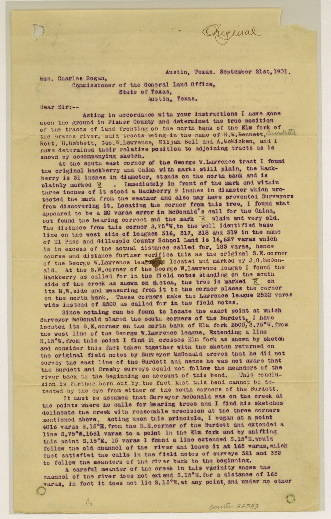
[Report of State Surveyor W. D. Twichell on resurvey of Geo. W. Lawrence, R. H. Hibbett, Burdett, Cosby and other surveys]
-
Map/Doc
22583
-
Collection
General Map Collection
-
Object Dates
1901/9/20 (Creation Date)
1901/9/21 (File Date)
-
People and Organizations
W.D. Twichell (Surveyor/Engineer)
-
Counties
Fisher
-
Subjects
Surveying Sketch File
-
Height x Width
14.4 x 9.2 inches
36.6 x 23.4 cm
-
Medium
paper, print
-
Features
Elm Fork of the Brazos River
Part of: General Map Collection
Right of Way and Track Map, the Missouri, Kansas and Texas Ry. of Texas - Henrietta Division

Print $20.00
- Digital $50.00
Right of Way and Track Map, the Missouri, Kansas and Texas Ry. of Texas - Henrietta Division
1918
Size 11.7 x 26.8 inches
Map/Doc 64767
Panola County Rolled Sketch 6

Print $40.00
- Digital $50.00
Panola County Rolled Sketch 6
1956
Size 26.0 x 55.7 inches
Map/Doc 9679
Presidio County Rolled Sketch 130

Print $40.00
- Digital $50.00
Presidio County Rolled Sketch 130
1993
Size 33.6 x 49.1 inches
Map/Doc 9800
Tom Green County Rolled Sketch 2

Print $20.00
- Digital $50.00
Tom Green County Rolled Sketch 2
Size 17.2 x 26.8 inches
Map/Doc 7992
Borden County Sketch File 2

Print $40.00
- Digital $50.00
Borden County Sketch File 2
Size 19.4 x 10.3 inches
Map/Doc 10932
Flight Mission No. DAH-17M, Frame 62, Orange County

Print $20.00
- Digital $50.00
Flight Mission No. DAH-17M, Frame 62, Orange County
1953
Size 18.5 x 22.6 inches
Map/Doc 86896
Galveston Bay, Texas

Print $20.00
- Digital $50.00
Galveston Bay, Texas
1905
Size 22.1 x 18.5 inches
Map/Doc 65389
Drainage Basins of Texas Streams

Print $20.00
- Digital $50.00
Drainage Basins of Texas Streams
Size 17.0 x 19.3 inches
Map/Doc 65269
State Prison System, Cherokee County

Print $20.00
- Digital $50.00
State Prison System, Cherokee County
Size 17.9 x 13.8 inches
Map/Doc 73561
Harbor Pass and Bar at Brazos Santiago, Texas

Print $20.00
- Digital $50.00
Harbor Pass and Bar at Brazos Santiago, Texas
1879
Size 18.2 x 27.6 inches
Map/Doc 72999
No. 3 Chart of Channel connecting Corpus Christi Bay with Aransas Bay, Texas

Print $20.00
- Digital $50.00
No. 3 Chart of Channel connecting Corpus Christi Bay with Aransas Bay, Texas
1878
Size 18.2 x 28.0 inches
Map/Doc 72772
Flight Mission No. BRA-7M, Frame 188, Jefferson County

Print $20.00
- Digital $50.00
Flight Mission No. BRA-7M, Frame 188, Jefferson County
1953
Size 18.6 x 22.3 inches
Map/Doc 85556
You may also like
Hockley County, Texas

Print $20.00
- Digital $50.00
Hockley County, Texas
Size 34.0 x 37.4 inches
Map/Doc 91200
Wood County Boundary File 4

Print $6.00
- Digital $50.00
Wood County Boundary File 4
Size 12.1 x 8.1 inches
Map/Doc 60167
Wood County Working Sketch 17

Print $20.00
- Digital $50.00
Wood County Working Sketch 17
Size 24.0 x 31.3 inches
Map/Doc 62017
Presidio County Working Sketch 134

Print $40.00
- Digital $50.00
Presidio County Working Sketch 134
1989
Size 37.0 x 55.6 inches
Map/Doc 71812
Rains County Sketch File 3

Print $8.00
- Digital $50.00
Rains County Sketch File 3
1849
Size 6.0 x 8.6 inches
Map/Doc 34947
[Sketch for Mineral Application 26501 - Sabine River, T. A. Oldhausen]
![2845, [Sketch for Mineral Application 26501 - Sabine River, T. A. Oldhausen], General Map Collection](https://historictexasmaps.com/wmedia_w700/maps/2845.tif.jpg)
Print $20.00
- Digital $50.00
[Sketch for Mineral Application 26501 - Sabine River, T. A. Oldhausen]
1931
Size 24.0 x 36.9 inches
Map/Doc 2845
Ector County Working Sketch 33

Print $20.00
- Digital $50.00
Ector County Working Sketch 33
1982
Size 24.7 x 29.0 inches
Map/Doc 68876
[Leagues 589-598, 627-630, part of Black Water Pasture]
![90259, [Leagues 589-598, 627-630, part of Black Water Pasture], Twichell Survey Records](https://historictexasmaps.com/wmedia_w700/maps/90259-1.tif.jpg)
Print $3.00
- Digital $50.00
[Leagues 589-598, 627-630, part of Black Water Pasture]
Size 14.5 x 11.5 inches
Map/Doc 90259
Lampasas County Sketch File 16

Print $20.00
- Digital $50.00
Lampasas County Sketch File 16
1893
Size 22.8 x 20.8 inches
Map/Doc 11976
Crane County Working Sketch 17

Print $40.00
- Digital $50.00
Crane County Working Sketch 17
1957
Size 121.8 x 50.0 inches
Map/Doc 68294
Wise County Sketch File 7

Print $4.00
- Digital $50.00
Wise County Sketch File 7
1857
Size 8.1 x 14.0 inches
Map/Doc 40535
Terrell County Working Sketch 8b

Print $20.00
- Digital $50.00
Terrell County Working Sketch 8b
1916
Size 15.1 x 18.6 inches
Map/Doc 69695