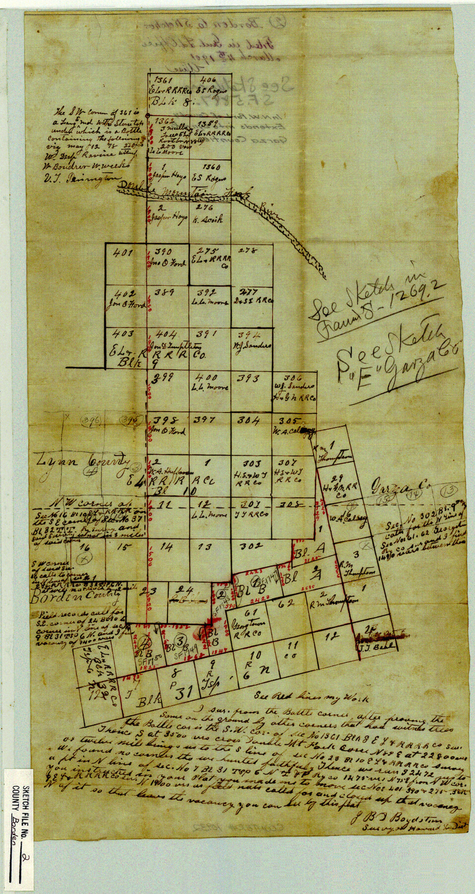
Borden County Sketch File 2
[Sketch of area in northwest part of county]
-
Map/Doc
10932
-
Collection
General Map Collection
-
Object Dates
1901/3/4 (File Date)
-
People and Organizations
J.B.D. Boydstun (Surveyor/Engineer)
-
Counties
Borden Garza Lynn
-
Subjects
Surveying Sketch File
-
Height x Width
19.4 x 10.3 inches
49.3 x 26.2 cm
-
Medium
paper, manuscript
-
Features
Double Mountain Fork River
Part of: General Map Collection
Atascosa County Sketch File 27c

Print $12.00
- Digital $50.00
Atascosa County Sketch File 27c
1876
Size 12.7 x 8.4 inches
Map/Doc 13806
Shackelford County Boundary File 2

Print $88.00
- Digital $50.00
Shackelford County Boundary File 2
Size 8.7 x 5.3 inches
Map/Doc 58633
Orange County Working Sketch 42

Print $20.00
- Digital $50.00
Orange County Working Sketch 42
1979
Size 19.6 x 25.4 inches
Map/Doc 71374
Childress County Sketch File 24

Print $4.00
- Digital $50.00
Childress County Sketch File 24
1917
Size 12.9 x 8.6 inches
Map/Doc 18384
Reeves County Working Sketch 15

Print $40.00
- Digital $50.00
Reeves County Working Sketch 15
1961
Size 43.0 x 53.1 inches
Map/Doc 63458
Galveston Harbor, Texas - U.S. Harbor Lines - Galveston Harbor, Galveston Channel, Channel from Galveston Harbor to Texas City and Channel to Port Bolivar

Print $20.00
- Digital $50.00
Galveston Harbor, Texas - U.S. Harbor Lines - Galveston Harbor, Galveston Channel, Channel from Galveston Harbor to Texas City and Channel to Port Bolivar
1939
Size 39.4 x 26.7 inches
Map/Doc 73631
Aransas County NRC Article 33.136 Sketch 3

Print $20.00
- Digital $50.00
Aransas County NRC Article 33.136 Sketch 3
2003
Size 25.1 x 36.1 inches
Map/Doc 80138
Map of Cherokee County

Print $40.00
- Digital $50.00
Map of Cherokee County
1933
Size 59.9 x 41.5 inches
Map/Doc 1799
Cass County Rolled Sketch WDC

Print $20.00
- Digital $50.00
Cass County Rolled Sketch WDC
Size 20.8 x 32.9 inches
Map/Doc 5416
Wharton County Boundary File 1

Print $24.00
- Digital $50.00
Wharton County Boundary File 1
Size 14.2 x 8.9 inches
Map/Doc 59839
Dallas County

Print $20.00
- Digital $50.00
Dallas County
1942
Size 44.5 x 36.9 inches
Map/Doc 95475
Cherokee County Sketch File 33

Print $16.00
- Digital $50.00
Cherokee County Sketch File 33
1935
Size 11.5 x 7.2 inches
Map/Doc 18190
You may also like
Presidio County Working Sketch 29

Print $20.00
- Digital $50.00
Presidio County Working Sketch 29
1946
Size 40.0 x 36.6 inches
Map/Doc 71705
Webb County Working Sketch 60

Print $20.00
- Digital $50.00
Webb County Working Sketch 60
1960
Size 43.3 x 47.8 inches
Map/Doc 72426
A.R. Roessler's Latest Map of the State of Texas Exhibiting Mineral and Agricultural Districts, Post Offices and Mailroutes, Railroads projected and finished, Timber, Prairie, Swamp Lands, etc. etc. etc.

Print $20.00
A.R. Roessler's Latest Map of the State of Texas Exhibiting Mineral and Agricultural Districts, Post Offices and Mailroutes, Railroads projected and finished, Timber, Prairie, Swamp Lands, etc. etc. etc.
1874
Size 39.7 x 46.8 inches
Map/Doc 76254
Coke County Rolled Sketch 12

Print $20.00
- Digital $50.00
Coke County Rolled Sketch 12
1949
Size 32.7 x 38.8 inches
Map/Doc 8626
The Republic County of Colorado. Spring 1842

Print $20.00
The Republic County of Colorado. Spring 1842
2020
Size 18.4 x 21.7 inches
Map/Doc 96126
[H. & T. C. RR. Company, Block 47 and vicinity]
![91246, [H. & T. C. RR. Company, Block 47 and vicinity], Twichell Survey Records](https://historictexasmaps.com/wmedia_w700/maps/91246-1.tif.jpg)
Print $20.00
- Digital $50.00
[H. & T. C. RR. Company, Block 47 and vicinity]
Size 37.6 x 26.3 inches
Map/Doc 91246
Aransas County Working Sketch 18

Print $20.00
- Digital $50.00
Aransas County Working Sketch 18
1961
Size 36.0 x 30.7 inches
Map/Doc 67185
University Land Field Notes for Block 19 in Loving and Ward Counties, Block 20 in Loving, Ward, and Winkler Counties, Blocks 16 and 18 in Ward County, Block 17 in Ward and Winkler Counties, and Block 21 in Winkler County

University Land Field Notes for Block 19 in Loving and Ward Counties, Block 20 in Loving, Ward, and Winkler Counties, Blocks 16 and 18 in Ward County, Block 17 in Ward and Winkler Counties, and Block 21 in Winkler County
Map/Doc 81709
Site Development Study for the D. M. Cogdell Memorial Hospital Snyder, Texas

Print $20.00
- Digital $50.00
Site Development Study for the D. M. Cogdell Memorial Hospital Snyder, Texas
Size 24.1 x 26.8 inches
Map/Doc 92922
Callahan County Sketch File 14

Print $40.00
- Digital $50.00
Callahan County Sketch File 14
1938
Size 20.5 x 26.1 inches
Map/Doc 11042
Flight Mission No. CRC-1R, Frame 151, Chambers County

Print $20.00
- Digital $50.00
Flight Mission No. CRC-1R, Frame 151, Chambers County
1956
Size 18.7 x 22.4 inches
Map/Doc 84713
Presidio County Sketch File 44

Print $15.00
- Digital $50.00
Presidio County Sketch File 44
1913
Size 11.1 x 9.5 inches
Map/Doc 34525