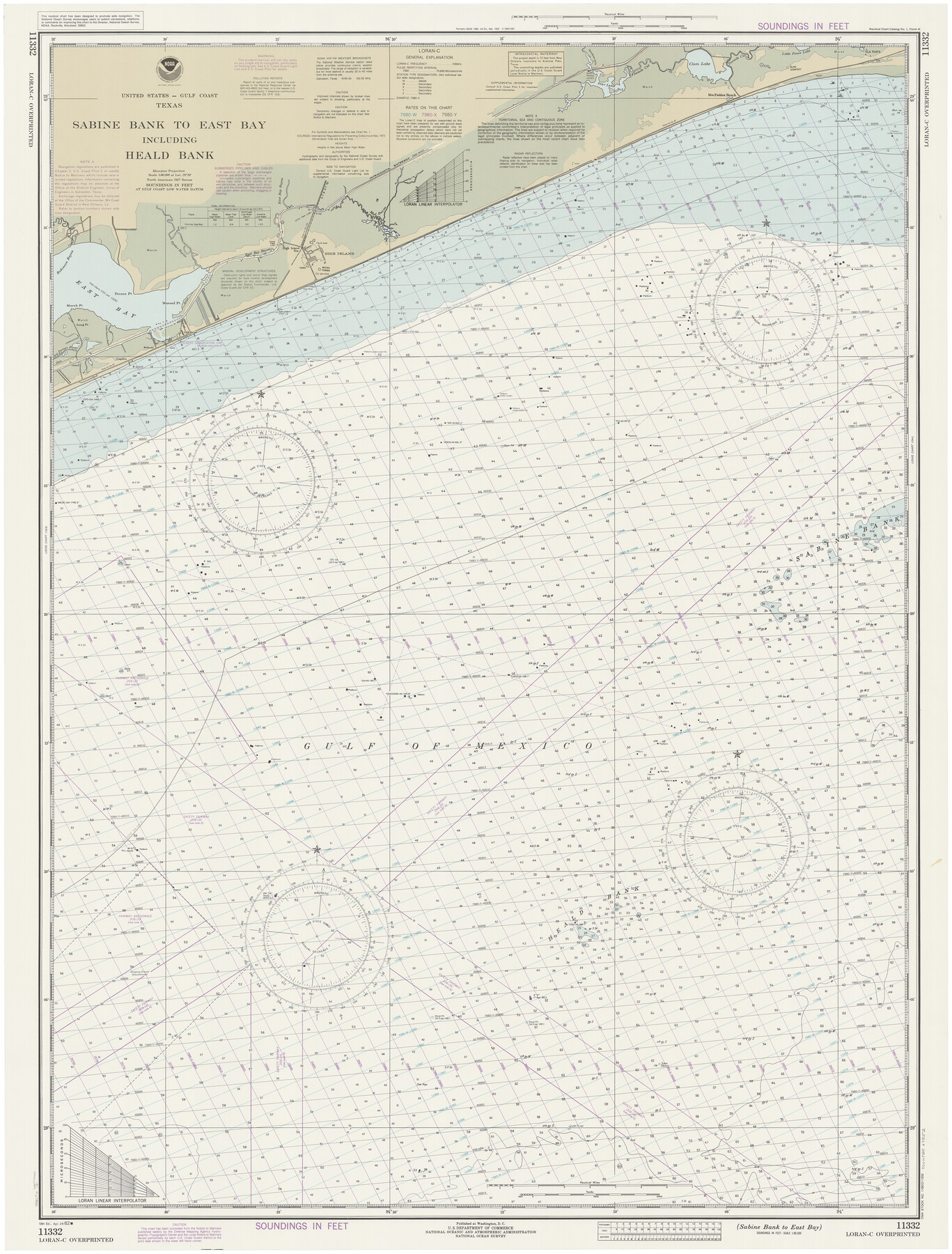
Sabine Bank to East Bay including Heald Bank
K-6-1280
-
Map/Doc
69852
-
Collection
General Map Collection
-
Object Dates
1982/4/24 (Creation Date)
-
Counties
Jefferson Galveston Chambers
-
Subjects
Nautical Charts
-
Height x Width
44.8 x 34.3 inches
113.8 x 87.1 cm
Part of: General Map Collection
Edwards County Working Sketch 90

Print $20.00
- Digital $50.00
Edwards County Working Sketch 90
1966
Size 33.6 x 27.2 inches
Map/Doc 68966
Flight Mission No. DIX-3P, Frame 165, Aransas County

Print $20.00
- Digital $50.00
Flight Mission No. DIX-3P, Frame 165, Aransas County
1956
Size 17.8 x 18.4 inches
Map/Doc 83771
Hall County Working Sketch 8

Print $20.00
- Digital $50.00
Hall County Working Sketch 8
1959
Size 29.4 x 32.8 inches
Map/Doc 63336
Louisiana and Texas Intracoastal Waterway Proposed Extension to Rio Grande Valley

Print $20.00
- Digital $50.00
Louisiana and Texas Intracoastal Waterway Proposed Extension to Rio Grande Valley
1941
Size 28.0 x 41.3 inches
Map/Doc 61892
Flight Mission No. BQY-14M, Frame 184, Harris County

Print $20.00
- Digital $50.00
Flight Mission No. BQY-14M, Frame 184, Harris County
1953
Size 18.6 x 22.4 inches
Map/Doc 85300
Maps of Gulf Intracoastal Waterway, Texas - Sabine River to the Rio Grande and connecting waterways including ship channels

Print $20.00
- Digital $50.00
Maps of Gulf Intracoastal Waterway, Texas - Sabine River to the Rio Grande and connecting waterways including ship channels
1966
Size 14.6 x 22.2 inches
Map/Doc 61947
[Reconnaissance report of Lieut. Scariott around Laguna del Madre and up to Fort San Saba]
![73006, [Reconnaissance report of Lieut. Scariott around Laguna del Madre and up to Fort San Saba], General Map Collection](https://historictexasmaps.com/wmedia_w700/maps/73006.tif.jpg)
Print $20.00
- Digital $50.00
[Reconnaissance report of Lieut. Scariott around Laguna del Madre and up to Fort San Saba]
Size 25.2 x 18.2 inches
Map/Doc 73006
Crockett County Sketch File 10

Print $20.00
- Digital $50.00
Crockett County Sketch File 10
Size 14.0 x 12.7 inches
Map/Doc 75924

Bastrop County Working Sketch 9

Print $20.00
- Digital $50.00
Bastrop County Working Sketch 9
1981
Size 44.9 x 43.7 inches
Map/Doc 67309
Hall County Sketch File C2

Print $6.00
- Digital $50.00
Hall County Sketch File C2
1905
Size 14.4 x 9.0 inches
Map/Doc 24789
Gray County Working Sketch 1

Print $20.00
- Digital $50.00
Gray County Working Sketch 1
1957
Size 37.3 x 17.4 inches
Map/Doc 62196
You may also like
[H. & G. N. Block 1, Sections 128-130]
![90948, [H. & G. N. Block 1, Sections 128-130], Twichell Survey Records](https://historictexasmaps.com/wmedia_w700/maps/90948-1.tif.jpg)
Print $20.00
- Digital $50.00
[H. & G. N. Block 1, Sections 128-130]
Size 36.6 x 11.9 inches
Map/Doc 90948
New Birmingham, Cherokee County, Texas

Print $20.00
- Digital $50.00
New Birmingham, Cherokee County, Texas
1891
Size 23.1 x 19.2 inches
Map/Doc 96617
Van Zandt County Sketch File 47a

Print $7.00
- Digital $50.00
Van Zandt County Sketch File 47a
1875
Size 10.0 x 8.2 inches
Map/Doc 39507
Harris County Working Sketch 5

Print $20.00
- Digital $50.00
Harris County Working Sketch 5
Size 35.1 x 28.0 inches
Map/Doc 65897
[Section 34, Block 194 G. C. & S. F.]
![91671, [Section 34, Block 194 G. C. & S. F.], Twichell Survey Records](https://historictexasmaps.com/wmedia_w700/maps/91671-1.tif.jpg)
Print $2.00
- Digital $50.00
[Section 34, Block 194 G. C. & S. F.]
1927
Size 7.6 x 5.9 inches
Map/Doc 91671
Andrews County Working Sketch 18

Print $20.00
- Digital $50.00
Andrews County Working Sketch 18
1964
Size 42.2 x 26.5 inches
Map/Doc 67064
Littlefield, being a part of League 664, Lamb County, Texas

Print $20.00
- Digital $50.00
Littlefield, being a part of League 664, Lamb County, Texas
1912
Size 30.5 x 16.9 inches
Map/Doc 92150
Crockett County Sketch File 96

Print $4.00
- Digital $50.00
Crockett County Sketch File 96
1934
Size 11.4 x 8.9 inches
Map/Doc 19964
Sutton County Sketch File 48

Print $4.00
- Digital $50.00
Sutton County Sketch File 48
1939
Size 11.3 x 8.7 inches
Map/Doc 37521
Flight Mission No. BRA-16M, Frame 183, Jefferson County

Print $20.00
- Digital $50.00
Flight Mission No. BRA-16M, Frame 183, Jefferson County
1953
Size 18.7 x 22.5 inches
Map/Doc 85781
Navigation Maps of Gulf Intracoastal Waterway, Port Arthur to Brownsville, Texas

Print $4.00
- Digital $50.00
Navigation Maps of Gulf Intracoastal Waterway, Port Arthur to Brownsville, Texas
1951
Size 16.6 x 21.4 inches
Map/Doc 65448
Live Oak County Working Sketch 18

Print $20.00
- Digital $50.00
Live Oak County Working Sketch 18
1961
Size 30.2 x 29.6 inches
Map/Doc 70603