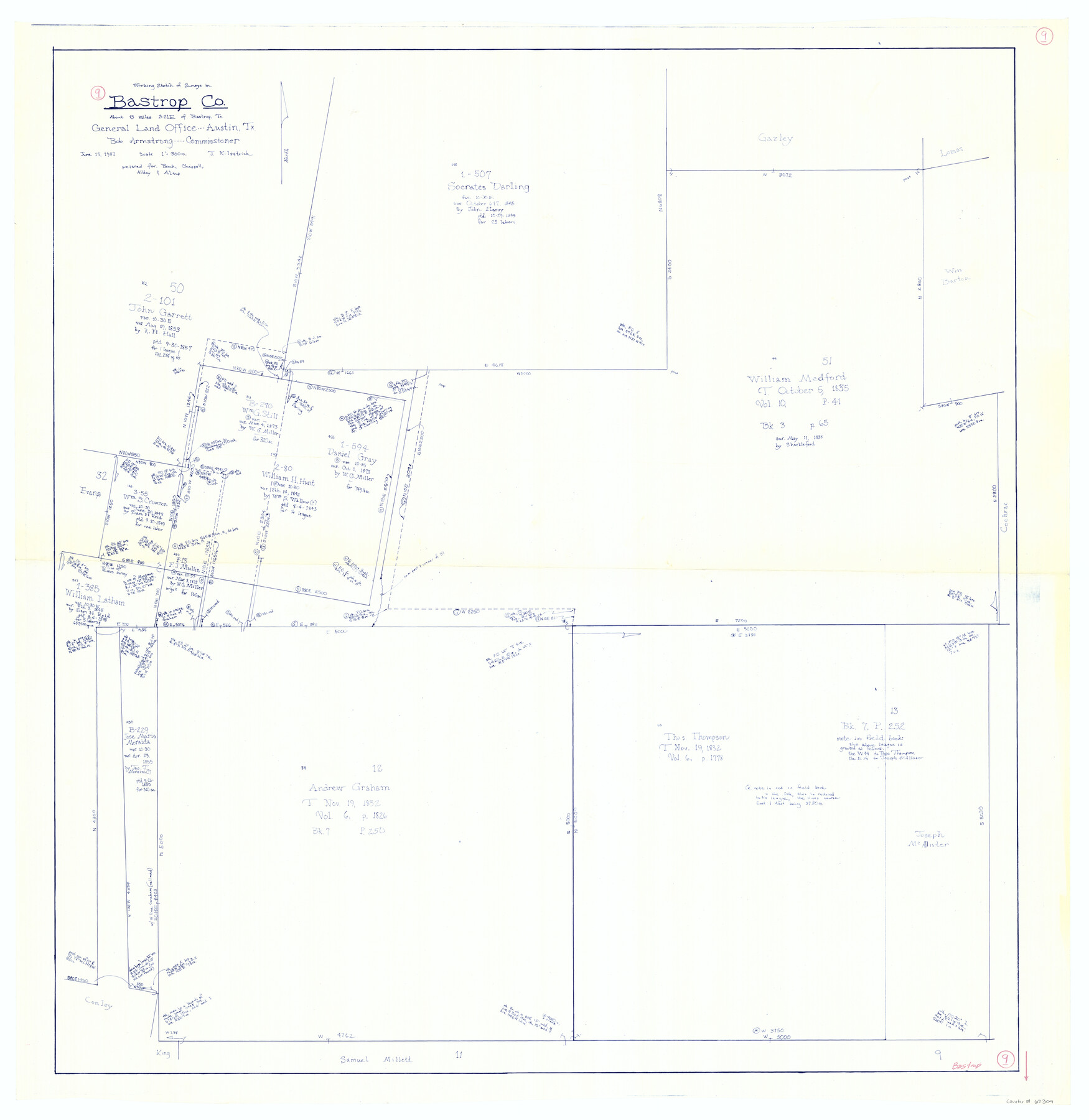
Bastrop County Working Sketch 9
-
Map/Doc
67309
-
Collection
General Map Collection
-
Object Dates
6/15/1981 (Creation Date)
-
People and Organizations
Joan Kilpatrick (Draftsman)
Bob Armstrong (GLO Commissioner)
-
Counties
Bastrop
-
Subjects
Surveying Working Sketch
-
Height x Width
44.9 x 43.7 inches
114.1 x 111.0 cm
-
Scale
1" = 300 varas
-
Comments
Surveys located about 13 miles South 21 degrees East of Bastrop, Texas.
Part of: General Map Collection
Rusk County Rolled Sketch 10

Print $18.00
- Digital $50.00
Rusk County Rolled Sketch 10
Size 9.7 x 11.3 inches
Map/Doc 48864
Hood County Sketch File 2

Print $4.00
- Digital $50.00
Hood County Sketch File 2
Size 9.7 x 8.2 inches
Map/Doc 26571
Atascosa County Sketch File 27c

Print $12.00
- Digital $50.00
Atascosa County Sketch File 27c
1876
Size 12.7 x 8.4 inches
Map/Doc 13806
Terrell County Working Sketch 8a

Print $20.00
- Digital $50.00
Terrell County Working Sketch 8a
1917
Size 14.5 x 19.4 inches
Map/Doc 62157
Pecos County Working Sketch Graphic Index - northwest part - sheet B

Print $20.00
- Digital $50.00
Pecos County Working Sketch Graphic Index - northwest part - sheet B
1975
Size 42.1 x 42.6 inches
Map/Doc 76664
Roberts County Working Sketch 20

Print $20.00
- Digital $50.00
Roberts County Working Sketch 20
1977
Size 25.6 x 32.9 inches
Map/Doc 63546
Shores of Laguna Madre, Texas from Triangulation Station Camp No. 2 to Triangulation Station Peat ID

Print $40.00
- Digital $50.00
Shores of Laguna Madre, Texas from Triangulation Station Camp No. 2 to Triangulation Station Peat ID
1882
Size 54.8 x 32.3 inches
Map/Doc 73482
Live Oak County Sketch File 19

Print $22.00
- Digital $50.00
Live Oak County Sketch File 19
1930
Size 11.2 x 8.6 inches
Map/Doc 30289
Oldham County Rolled Sketch 2A

Print $40.00
- Digital $50.00
Oldham County Rolled Sketch 2A
1886
Size 35.9 x 55.6 inches
Map/Doc 9640
Cherokee County Working Sketch 6

Print $20.00
- Digital $50.00
Cherokee County Working Sketch 6
1953
Size 40.9 x 35.1 inches
Map/Doc 67961
Edwards County Working Sketch 28

Print $20.00
- Digital $50.00
Edwards County Working Sketch 28
1946
Size 30.0 x 33.5 inches
Map/Doc 68904
Grayson County Rolled Sketch 1

Print $20.00
- Digital $50.00
Grayson County Rolled Sketch 1
1944
Size 43.4 x 29.0 inches
Map/Doc 6029
You may also like
Hockley County Sketch File 2

Print $20.00
- Digital $50.00
Hockley County Sketch File 2
1900
Size 13.2 x 18.1 inches
Map/Doc 11768

[Sketch for Mineral Application 16700 - Pecos River Bed]
![2808, [Sketch for Mineral Application 16700 - Pecos River Bed], General Map Collection](https://historictexasmaps.com/wmedia_w700/maps/2808.tif.jpg)
Print $20.00
- Digital $50.00
[Sketch for Mineral Application 16700 - Pecos River Bed]
1927
Size 19.9 x 30.9 inches
Map/Doc 2808
Yates Pool, Pecos County, Texas

Print $20.00
- Digital $50.00
Yates Pool, Pecos County, Texas
1928
Size 21.3 x 18.3 inches
Map/Doc 91623
1882 Map of the Texas & Pacific R-Y Reserve

Print $20.00
- Digital $50.00
1882 Map of the Texas & Pacific R-Y Reserve
1887
Size 44.6 x 29.8 inches
Map/Doc 83561
'O Bar O' Ranch

Print $20.00
- Digital $50.00
'O Bar O' Ranch
1946
Size 21.1 x 36.2 inches
Map/Doc 92162
[Blk. B, Secs. 111-114 and vicinity]
![90340, [Blk. B, Secs. 111-114 and vicinity], Twichell Survey Records](https://historictexasmaps.com/wmedia_w700/maps/90340-1.tif.jpg)
Print $20.00
- Digital $50.00
[Blk. B, Secs. 111-114 and vicinity]
Size 31.3 x 38.7 inches
Map/Doc 90340
San Jacinto County Sketch File 23

Print $26.00
San Jacinto County Sketch File 23
1993
Size 14.6 x 8.8 inches
Map/Doc 35803
Potter County

Print $20.00
- Digital $50.00
Potter County
1909
Size 45.3 x 40.6 inches
Map/Doc 16790
Blanco County Working Sketch 32

Print $20.00
- Digital $50.00
Blanco County Working Sketch 32
1972
Size 31.8 x 32.2 inches
Map/Doc 67392
Lampasas County Sketch File 16 1/2

Print $4.00
- Digital $50.00
Lampasas County Sketch File 16 1/2
Size 8.4 x 8.6 inches
Map/Doc 29428
Aransas County Boundary File 7

Print $2.00
- Digital $50.00
Aransas County Boundary File 7
Size 8.8 x 14.2 inches
Map/Doc 50042