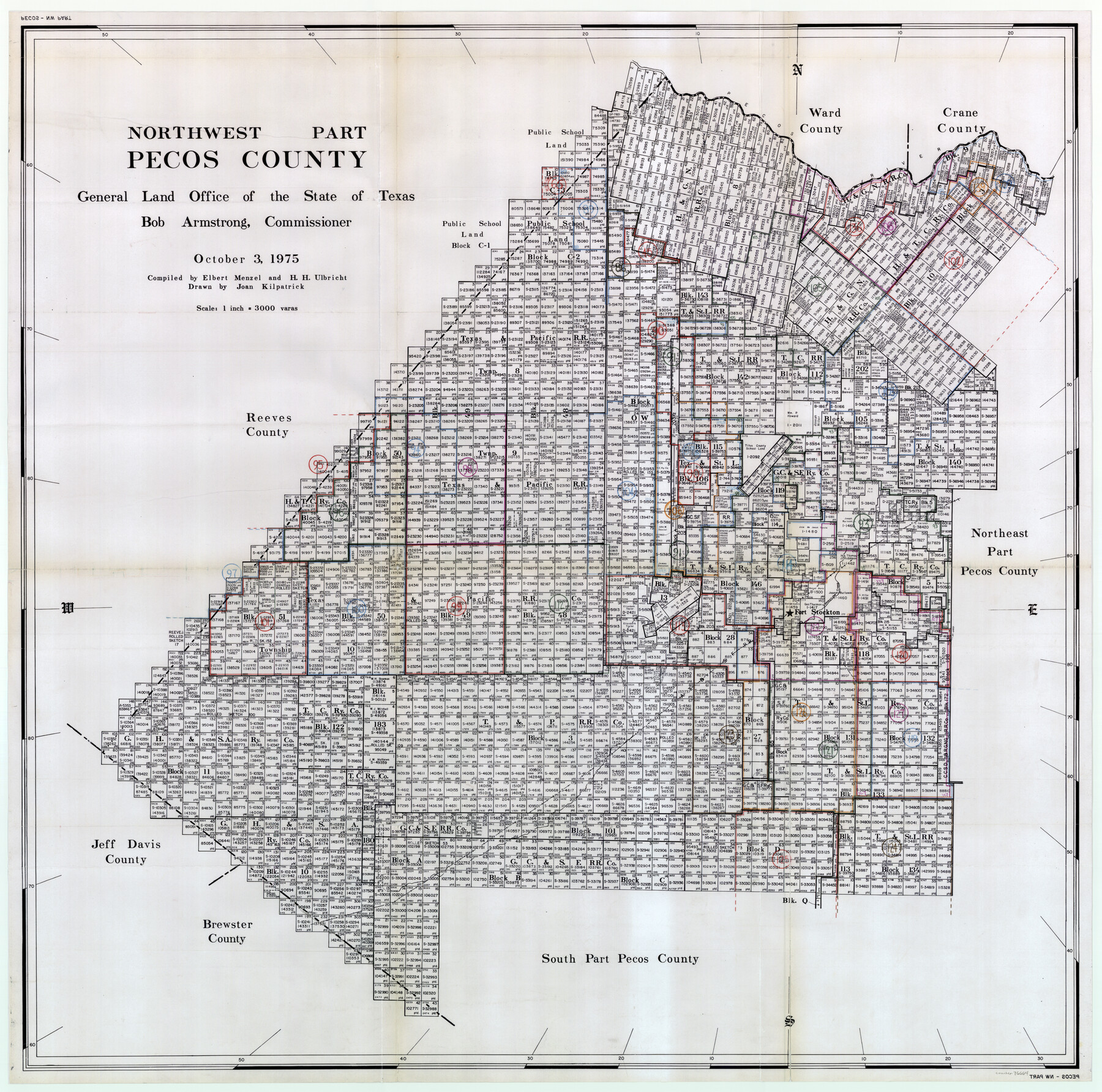
Pecos County Working Sketch Graphic Index - northwest part - sheet B
-
Map/Doc
76664
-
Collection
General Map Collection
-
Object Dates
10/3/1975 (Creation Date)
-
People and Organizations
Elbert Menzel (Compiler)
Herbert H. Ulbricht (Compiler)
Joan Kilpatrick (Draftsman)
-
Counties
Pecos
-
Subjects
County Surveying Working Sketch
-
Height x Width
42.1 x 42.6 inches
106.9 x 108.2 cm
-
Scale
1" = 3000 varas
Part of: General Map Collection
Flight Mission No. DIX-7P, Frame 83, Aransas County

Print $20.00
- Digital $50.00
Flight Mission No. DIX-7P, Frame 83, Aransas County
1956
Size 18.8 x 22.5 inches
Map/Doc 83877
Flight Mission No. CLL-1N, Frame 16, Willacy County

Print $20.00
- Digital $50.00
Flight Mission No. CLL-1N, Frame 16, Willacy County
1954
Size 18.3 x 22.0 inches
Map/Doc 87003
Smith County Rolled Sketch 2

Print $20.00
- Digital $50.00
Smith County Rolled Sketch 2
Size 36.6 x 35.5 inches
Map/Doc 75931
Brazoria County Working Sketch 27

Print $20.00
- Digital $50.00
Brazoria County Working Sketch 27
1970
Size 41.8 x 32.5 inches
Map/Doc 67512
Liberty County Sketch File 13

Print $12.00
- Digital $50.00
Liberty County Sketch File 13
1858
Size 8.3 x 7.9 inches
Map/Doc 29909
Val Verde County Working Sketch 44

Print $40.00
- Digital $50.00
Val Verde County Working Sketch 44
1945
Size 49.7 x 39.5 inches
Map/Doc 72179
Richardson's New Map of the State of Texas prepared for the Texas Almanac

Print $20.00
- Digital $50.00
Richardson's New Map of the State of Texas prepared for the Texas Almanac
1873
Size 19.8 x 27.1 inches
Map/Doc 96873
Sutton County Sketch File 3

Print $8.00
- Digital $50.00
Sutton County Sketch File 3
Size 12.9 x 8.5 inches
Map/Doc 37353
Waller County

Print $40.00
- Digital $50.00
Waller County
1945
Size 48.5 x 28.9 inches
Map/Doc 73315
El Paso County Sketch File 30

Print $4.00
- Digital $50.00
El Paso County Sketch File 30
1960
Size 11.2 x 8.8 inches
Map/Doc 22082

Mitchell County Boundary File 66

Print $13.00
- Digital $50.00
Mitchell County Boundary File 66
Size 7.9 x 3.7 inches
Map/Doc 57372
You may also like
Orange County Sketch File 11a

Print $4.00
- Digital $50.00
Orange County Sketch File 11a
1884
Size 6.1 x 6.1 inches
Map/Doc 33322
General Highway Map, Glasscock County, Texas

Print $20.00
General Highway Map, Glasscock County, Texas
1940
Size 18.5 x 25.2 inches
Map/Doc 79100
Map of Hays County Travis District

Print $20.00
- Digital $50.00
Map of Hays County Travis District
1861
Size 18.6 x 26.0 inches
Map/Doc 3648
Crockett County Working Sketch 12

Print $20.00
- Digital $50.00
Crockett County Working Sketch 12
1915
Size 19.3 x 15.4 inches
Map/Doc 68345
Reagan County Rolled Sketch 10

Print $20.00
- Digital $50.00
Reagan County Rolled Sketch 10
1939
Size 18.7 x 15.8 inches
Map/Doc 7438
Jasper County Working Sketch 33

Print $20.00
- Digital $50.00
Jasper County Working Sketch 33
1999
Size 30.4 x 17.5 inches
Map/Doc 66495
Sabine River, Rocky Ford Crossing Sheet/Cowleach Fork of the Sabine River

Print $20.00
- Digital $50.00
Sabine River, Rocky Ford Crossing Sheet/Cowleach Fork of the Sabine River
1936
Size 38.9 x 29.2 inches
Map/Doc 65144
Collin County Boundary File 2

Print $6.00
- Digital $50.00
Collin County Boundary File 2
Size 12.9 x 8.0 inches
Map/Doc 51682
Kimble County Sketch File 27

Print $6.00
- Digital $50.00
Kimble County Sketch File 27
1913
Size 11.4 x 9.7 inches
Map/Doc 28971
Harris County Rolled Sketch 80A

Print $40.00
- Digital $50.00
Harris County Rolled Sketch 80A
Size 42.8 x 52.6 inches
Map/Doc 9136
Bandera County Working Sketch 14

Print $20.00
- Digital $50.00
Bandera County Working Sketch 14
1934
Size 28.0 x 30.9 inches
Map/Doc 67607
Lands of Gunter & Munson and Maddox Bros. & Anderson, Tom Green Co. Tex.

Print $20.00
- Digital $50.00
Lands of Gunter & Munson and Maddox Bros. & Anderson, Tom Green Co. Tex.
Size 20.4 x 30.7 inches
Map/Doc 75787