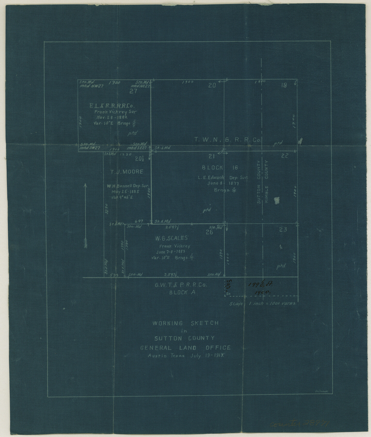
Kimble County Sketch File 27
[Working sketch of surveys along Sutton-Kimble County line in northwest corner of Kimble County]
-
Map/Doc
28971
-
Collection
General Map Collection
-
Object Dates
7/19/1913 (Creation Date)
7/19/1913 (File Date)
-
People and Organizations
Pritchett (Surveyor/Engineer)
Frank Vickrey (Surveyor/Engineer)
-
Counties
Kimble Sutton
-
Subjects
Surveying Sketch File
-
Height x Width
11.4 x 9.7 inches
29.0 x 24.6 cm
-
Medium
blueprint/diazo
-
Scale
1" = 1000 varas
Part of: General Map Collection
Bastrop County

Print $20.00
- Digital $50.00
Bastrop County
1917
Size 45.5 x 40.8 inches
Map/Doc 66711
Panola County Working Sketch 14

Print $40.00
- Digital $50.00
Panola County Working Sketch 14
1945
Map/Doc 71423
Hemphill County Rolled Sketch 2

Print $20.00
- Digital $50.00
Hemphill County Rolled Sketch 2
Size 26.4 x 29.8 inches
Map/Doc 6185
Red River County Working Sketch 52

Print $20.00
- Digital $50.00
Red River County Working Sketch 52
1971
Size 35.5 x 24.7 inches
Map/Doc 72035
[Surveys in Austin's Colony along the east bank of Mill Creek]
![216, [Surveys in Austin's Colony along the east bank of Mill Creek], General Map Collection](https://historictexasmaps.com/wmedia_w700/maps/216.tif.jpg)
Print $3.00
- Digital $50.00
[Surveys in Austin's Colony along the east bank of Mill Creek]
1827
Size 14.4 x 11.1 inches
Map/Doc 216
Roberts County Working Sketch 27

Print $20.00
- Digital $50.00
Roberts County Working Sketch 27
1982
Size 26.6 x 29.4 inches
Map/Doc 63553
Topographical Map of the Rio Grande, Sheet No. 23

Print $20.00
- Digital $50.00
Topographical Map of the Rio Grande, Sheet No. 23
1912
Map/Doc 89547
Schleicher County Working Sketch 1

Print $20.00
- Digital $50.00
Schleicher County Working Sketch 1
1902
Size 14.8 x 17.4 inches
Map/Doc 63803
Motley County Sketch File 13 (N)

Print $10.00
- Digital $50.00
Motley County Sketch File 13 (N)
1911
Size 11.1 x 8.6 inches
Map/Doc 32043
Midland County Rolled Sketch 12

Print $40.00
- Digital $50.00
Midland County Rolled Sketch 12
Size 97.0 x 42.6 inches
Map/Doc 9520
Deaf Smith County Sketch File D

Print $20.00
- Digital $50.00
Deaf Smith County Sketch File D
Size 12.6 x 27.7 inches
Map/Doc 11306
Pecos County Working Sketch 119

Print $20.00
- Digital $50.00
Pecos County Working Sketch 119
1973
Size 42.8 x 30.9 inches
Map/Doc 71592
You may also like

El Paso County Working Sketch 12

Print $20.00
- Digital $50.00
El Paso County Working Sketch 12
1956
Size 33.0 x 41.4 inches
Map/Doc 69034
Map of Menard County, Texas

Print $20.00
- Digital $50.00
Map of Menard County, Texas
1879
Size 18.5 x 24.8 inches
Map/Doc 580
Flight Mission No. CUG-1P, Frame 104, Kleberg County

Print $20.00
- Digital $50.00
Flight Mission No. CUG-1P, Frame 104, Kleberg County
1956
Size 18.5 x 21.1 inches
Map/Doc 86154
Childress County Sketch File 2a

Print $20.00
- Digital $50.00
Childress County Sketch File 2a
Size 18.3 x 34.8 inches
Map/Doc 11077
Plano del Presidio de Nra. Senora del Pilar de los Adaes, Capital de la Provincia de los Tejas situado en 32 grados y 15 minutos de Latitud Boreal, y en 285° y 52' de Longitud respecto del Meridiano de Tenerife

Plano del Presidio de Nra. Senora del Pilar de los Adaes, Capital de la Provincia de los Tejas situado en 32 grados y 15 minutos de Latitud Boreal, y en 285° y 52' de Longitud respecto del Meridiano de Tenerife
Size 16.9 x 21.4 inches
Map/Doc 96563
Intracoastal Waterway in Texas - Corpus Christi to Point Isabel including Arroyo Colorado to Mo. Pac. R.R. Bridge Near Harlingen

Print $20.00
- Digital $50.00
Intracoastal Waterway in Texas - Corpus Christi to Point Isabel including Arroyo Colorado to Mo. Pac. R.R. Bridge Near Harlingen
1933
Size 27.9 x 41.0 inches
Map/Doc 61868
Sketch H No. V Showing the observed and computed Tidal Curves at Cat Island, Mississippi Sound in 1848 & 1849

Print $20.00
- Digital $50.00
Sketch H No. V Showing the observed and computed Tidal Curves at Cat Island, Mississippi Sound in 1848 & 1849
1852
Size 12.3 x 19.5 inches
Map/Doc 97226
Lakeview Addition to the City of Shallowater out of the Southeast 1/4 of Section 27, Block D5

Print $3.00
- Digital $50.00
Lakeview Addition to the City of Shallowater out of the Southeast 1/4 of Section 27, Block D5
1955
Size 17.9 x 11.6 inches
Map/Doc 92870
Port Facilities at Galveston, Tex.

Print $20.00
- Digital $50.00
Port Facilities at Galveston, Tex.
1924
Size 14.1 x 37.5 inches
Map/Doc 97173
Brewster County Rolled Sketch 82A

Print $40.00
- Digital $50.00
Brewster County Rolled Sketch 82A
1952
Size 74.3 x 34.0 inches
Map/Doc 8498
Coleman County Sketch File 40

Print $28.00
- Digital $50.00
Coleman County Sketch File 40
Size 14.3 x 8.9 inches
Map/Doc 18744