Brewster County Rolled Sketch 82A
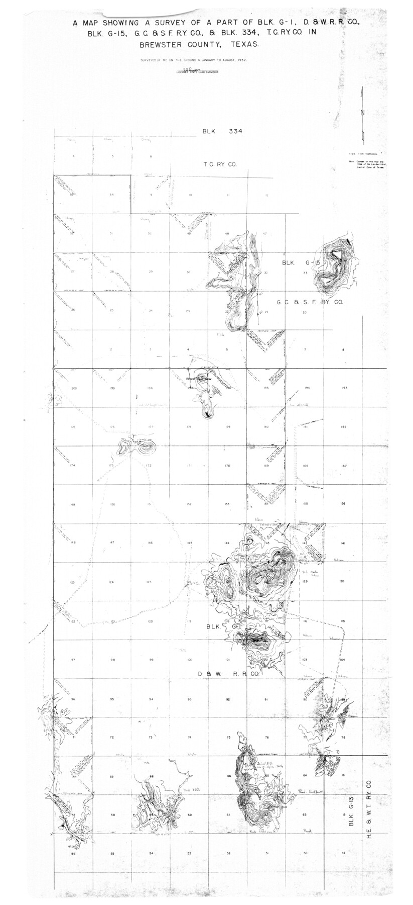
A map showing a survey of a part of Blk. G-1, D. & W. R.R. Co., Blk. G-15, G. C. & S. F. Ry. Co., & Blk. 334, T. C. Ry. Co. in Brewster County, Texas
-
Map/Doc
8498
-
Collection
General Map Collection
-
Object Dates
1952 (Creation Date)
1972/9/11 (File Date)
-
People and Organizations
J.A. Simpson (Surveyor/Engineer)
-
Counties
Brewster
-
Subjects
Surveying Rolled Sketch
-
Height x Width
74.3 x 34.0 inches
188.7 x 86.4 cm
-
Medium
blueprint/diazo
-
Scale
1" = 600 varas
-
Comments
See Brewster County Rolled Sketch 82 (5245) for additional sketch.
Related maps
Brewster County Rolled Sketch 82

Print $20.00
- Digital $50.00
Brewster County Rolled Sketch 82
1945
Size 20.3 x 23.3 inches
Map/Doc 5245
Part of: General Map Collection
Bee County Sketch File 8

Print $8.00
- Digital $50.00
Bee County Sketch File 8
1874
Size 12.4 x 8.0 inches
Map/Doc 14279
Amistad International Reservoir on Rio Grande 100

Print $20.00
- Digital $50.00
Amistad International Reservoir on Rio Grande 100
1950
Size 28.5 x 40.8 inches
Map/Doc 75531
Collingsworth County Working Sketch 5

Print $20.00
- Digital $50.00
Collingsworth County Working Sketch 5
1973
Size 22.5 x 38.2 inches
Map/Doc 68093
Val Verde County Sketch File M

Print $18.00
- Digital $50.00
Val Verde County Sketch File M
1920
Size 14.5 x 9.1 inches
Map/Doc 39275
Angelina County Working Sketch 36

Print $20.00
- Digital $50.00
Angelina County Working Sketch 36
1957
Size 14.4 x 18.3 inches
Map/Doc 67119
Irion County Sketch File 3

Print $20.00
- Digital $50.00
Irion County Sketch File 3
1891
Size 22.4 x 22.1 inches
Map/Doc 11823
Hunt County Sketch File 28

Print $4.00
- Digital $50.00
Hunt County Sketch File 28
1860
Size 8.5 x 8.2 inches
Map/Doc 27128
Concho County Sketch File 4

Print $2.00
- Digital $50.00
Concho County Sketch File 4
1858
Size 8.0 x 10.1 inches
Map/Doc 82523
Refugio County Boundary File 5

Print $4.00
- Digital $50.00
Refugio County Boundary File 5
Size 11.2 x 8.6 inches
Map/Doc 58256
Cameron County Rolled Sketch 25

Print $20.00
- Digital $50.00
Cameron County Rolled Sketch 25
1977
Size 24.8 x 36.5 inches
Map/Doc 5797
Henderson County Rolled Sketch 11

Print $20.00
- Digital $50.00
Henderson County Rolled Sketch 11
1915
Size 29.2 x 42.9 inches
Map/Doc 76149
Flight Mission No. BRA-8M, Frame 27, Jefferson County

Print $20.00
- Digital $50.00
Flight Mission No. BRA-8M, Frame 27, Jefferson County
1953
Size 18.6 x 22.3 inches
Map/Doc 85582
You may also like
Presidio County Rolled Sketch 92

Print $20.00
- Digital $50.00
Presidio County Rolled Sketch 92
1947
Size 18.5 x 18.9 inches
Map/Doc 7377
Bexar County Sketch File 21

Print $4.00
- Digital $50.00
Bexar County Sketch File 21
1859
Size 12.2 x 7.9 inches
Map/Doc 14484
Morley's Map of New Mexico compiled from the latest government surveys and other reliable sources

Print $20.00
- Digital $50.00
Morley's Map of New Mexico compiled from the latest government surveys and other reliable sources
1873
Size 26.2 x 28.0 inches
Map/Doc 94052
Lubbock County

Print $20.00
- Digital $50.00
Lubbock County
1968
Size 42.1 x 34.1 inches
Map/Doc 73226
General Highway Map, Dallam County, Hartley County, Texas

Print $20.00
General Highway Map, Dallam County, Hartley County, Texas
1940
Size 18.3 x 25.1 inches
Map/Doc 79065
Presidio County Sketch File A

Print $20.00
- Digital $50.00
Presidio County Sketch File A
Size 25.6 x 21.4 inches
Map/Doc 11700
Runnels County

Print $20.00
- Digital $50.00
Runnels County
1879
Size 22.1 x 19.2 inches
Map/Doc 3999
Hutchinson County Working Sketch 24

Print $20.00
- Digital $50.00
Hutchinson County Working Sketch 24
1967
Size 27.2 x 40.0 inches
Map/Doc 66384
Anderson County Sketch File 32

Print $4.00
- Digital $50.00
Anderson County Sketch File 32
2002
Size 11.3 x 8.8 inches
Map/Doc 78312
Schleicher County Sketch File 43

Print $6.00
- Digital $50.00
Schleicher County Sketch File 43
1965
Size 17.0 x 11.0 inches
Map/Doc 36548
Bailey County Sketch File 21

Print $14.00
- Digital $50.00
Bailey County Sketch File 21
Size 11.3 x 8.8 inches
Map/Doc 13990
Dallas County Boundary File 8 and 8a

Print $16.00
- Digital $50.00
Dallas County Boundary File 8 and 8a
Size 11.3 x 8.6 inches
Map/Doc 52304