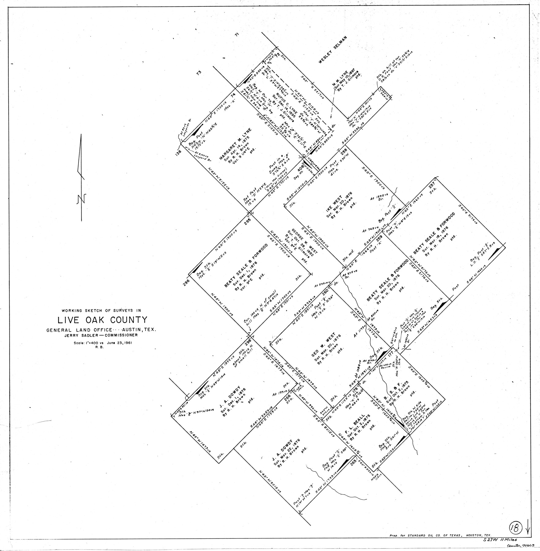
Live Oak County Working Sketch 18
-
Map/Doc
70603
-
Collection
General Map Collection
-
Object Dates
6/23/1961 (Creation Date)
-
People and Organizations
Roy Buckholts (Draftsman)
-
Counties
Live Oak
-
Subjects
Surveying Working Sketch
-
Height x Width
30.2 x 29.6 inches
76.7 x 75.2 cm
-
Scale
1" = 400 varas
Part of: General Map Collection
Travis County Appraisal District Plat Map 2_2512

Print $20.00
- Digital $50.00
Travis County Appraisal District Plat Map 2_2512
1938
Size 21.5 x 26.5 inches
Map/Doc 94216
Location of the Kansas City Shreveport & Gulf Railroad, Beaumont to Mayersburg

Print $20.00
- Digital $50.00
Location of the Kansas City Shreveport & Gulf Railroad, Beaumont to Mayersburg
1896
Size 26.0 x 36.5 inches
Map/Doc 64771
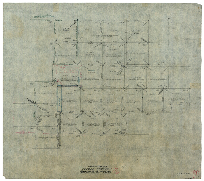
Duval County Working Sketch 9
Print $20.00
- Digital $50.00
Duval County Working Sketch 9
1935
Size 25.8 x 29.1 inches
Map/Doc 68722
Hudspeth County Working Sketch 47

Print $20.00
- Digital $50.00
Hudspeth County Working Sketch 47
1984
Size 27.3 x 38.6 inches
Map/Doc 78211
Flight Mission No. BQR-4K, Frame 68, Brazoria County

Print $20.00
- Digital $50.00
Flight Mission No. BQR-4K, Frame 68, Brazoria County
1952
Size 18.7 x 22.4 inches
Map/Doc 84001
Gaines County Working Sketch 6

Print $20.00
- Digital $50.00
Gaines County Working Sketch 6
1940
Size 25.0 x 40.8 inches
Map/Doc 69306
Starr County Rolled Sketch 27

Print $20.00
- Digital $50.00
Starr County Rolled Sketch 27
1940
Size 21.4 x 28.6 inches
Map/Doc 7810
Map Showing Part of the Blue Ridge Farm of the Texas Prison System, Fort Bend County, Texas

Print $20.00
- Digital $50.00
Map Showing Part of the Blue Ridge Farm of the Texas Prison System, Fort Bend County, Texas
Size 22.2 x 36.2 inches
Map/Doc 62979
Map of Texas and the country adjacent

Print $20.00
- Digital $50.00
Map of Texas and the country adjacent
1844
Size 18.3 x 26.5 inches
Map/Doc 73052
Map of Kendall County

Print $20.00
- Digital $50.00
Map of Kendall County
1899
Size 36.8 x 34.2 inches
Map/Doc 66887
Flight Mission No. CGI-3N, Frame 126, Cameron County

Print $20.00
- Digital $50.00
Flight Mission No. CGI-3N, Frame 126, Cameron County
1954
Size 18.5 x 22.1 inches
Map/Doc 84599
Live Oak County Working Sketch 25

Print $3.00
- Digital $50.00
Live Oak County Working Sketch 25
1980
Size 16.7 x 10.6 inches
Map/Doc 70610
You may also like
Northwest Part of Webb County

Print $40.00
- Digital $50.00
Northwest Part of Webb County
1984
Size 42.6 x 52.2 inches
Map/Doc 73319
[H. & T. C. Blocks 3 and 4; G. H. & S. A Blocks 2, 4, and 12; D. & P. Block 3]
![91027, [H. & T. C. Blocks 3 and 4; G. H. & S. A Blocks 2, 4, and 12; D. & P. Block 3], Twichell Survey Records](https://historictexasmaps.com/wmedia_w700/maps/91027-1.tif.jpg)
Print $20.00
- Digital $50.00
[H. & T. C. Blocks 3 and 4; G. H. & S. A Blocks 2, 4, and 12; D. & P. Block 3]
Size 44.6 x 36.3 inches
Map/Doc 91027
Tom Green County Working Sketch Graphic Index

Print $40.00
- Digital $50.00
Tom Green County Working Sketch Graphic Index
1942
Size 70.9 x 40.1 inches
Map/Doc 76715

Irion County Working Sketch 7

Print $20.00
- Digital $50.00
Irion County Working Sketch 7
1936
Size 14.4 x 42.7 inches
Map/Doc 66416
Bexar County Working Sketch 1

Print $20.00
- Digital $50.00
Bexar County Working Sketch 1
1935
Size 36.7 x 47.8 inches
Map/Doc 67317
Flight Mission No. DIX-6P, Frame 128, Aransas County

Print $20.00
- Digital $50.00
Flight Mission No. DIX-6P, Frame 128, Aransas County
1956
Size 19.2 x 22.6 inches
Map/Doc 83834
[Southeast Portion of Lubbock County]
![91313, [Southeast Portion of Lubbock County], Twichell Survey Records](https://historictexasmaps.com/wmedia_w700/maps/91313-1.tif.jpg)
Print $20.00
- Digital $50.00
[Southeast Portion of Lubbock County]
Size 24.7 x 18.5 inches
Map/Doc 91313
Map of Starr County State of Texas

Print $20.00
- Digital $50.00
Map of Starr County State of Texas
1911
Size 25.1 x 23.2 inches
Map/Doc 4048
McCulloch County Working Sketch 19

Print $20.00
- Digital $50.00
McCulloch County Working Sketch 19
2010
Size 32.6 x 27.0 inches
Map/Doc 89260
Station Map, the Missouri, Kansas and Texas Ry. Of Texas - Henrietta Division

Print $20.00
- Digital $50.00
Station Map, the Missouri, Kansas and Texas Ry. Of Texas - Henrietta Division
1918
Size 11.8 x 26.7 inches
Map/Doc 64763
Flight Mission No. BRA-9M, Frame 60, Jefferson County

Print $20.00
- Digital $50.00
Flight Mission No. BRA-9M, Frame 60, Jefferson County
1953
Size 18.6 x 22.4 inches
Map/Doc 85643