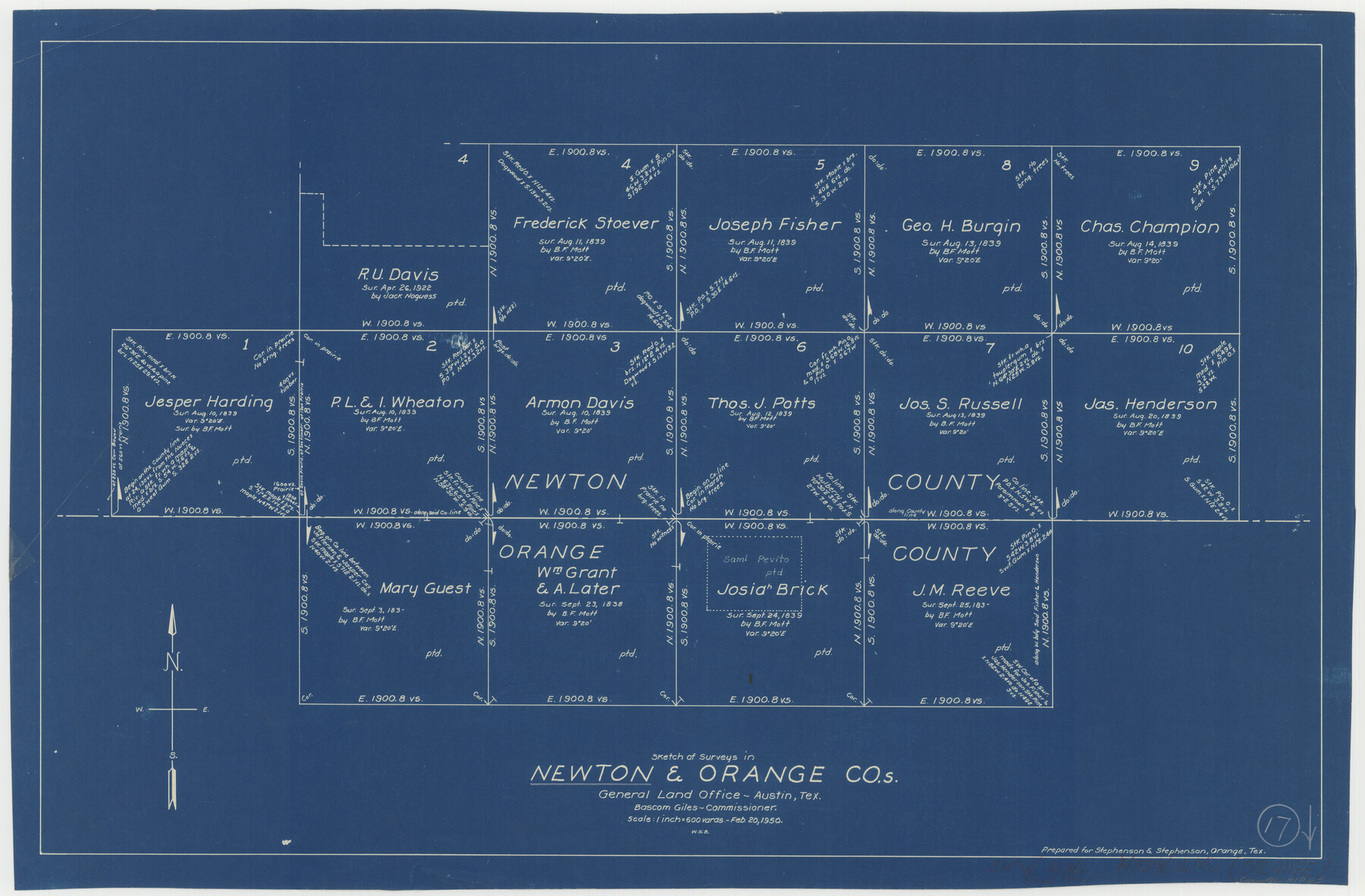
Newton County Working Sketch 17
-
Map/Doc
71263
-
Collection
General Map Collection
-
Object Dates
2/20/1950 (Creation Date)
-
People and Organizations
W. S. Brewington (Draftsman)
-
Counties
Newton Orange
-
Subjects
Surveying Working Sketch
-
Height x Width
15.1 x 23.0 inches
38.4 x 58.4 cm
-
Scale
1" = 600 varas
Part of: General Map Collection
Flight Mission No. DAG-24K, Frame 52, Matagorda County

Print $20.00
- Digital $50.00
Flight Mission No. DAG-24K, Frame 52, Matagorda County
1953
Size 17.0 x 15.8 inches
Map/Doc 86539
Flight Mission No. BQY-4M, Frame 65, Harris County

Print $20.00
- Digital $50.00
Flight Mission No. BQY-4M, Frame 65, Harris County
1953
Size 18.7 x 22.4 inches
Map/Doc 85274
Brazoria County Sketch File 20

Print $40.00
- Digital $50.00
Brazoria County Sketch File 20
1853
Size 22.3 x 15.0 inches
Map/Doc 10953
Upton County Working Sketch 16

Print $20.00
- Digital $50.00
Upton County Working Sketch 16
1941
Size 17.1 x 12.0 inches
Map/Doc 69512
Dickens County Rolled Sketch P2

Print $20.00
- Digital $50.00
Dickens County Rolled Sketch P2
1917
Size 41.5 x 36.4 inches
Map/Doc 8784
Crosby County Sketch File 4

Print $4.00
- Digital $50.00
Crosby County Sketch File 4
Size 8.6 x 12.6 inches
Map/Doc 20000
San Augustine County Working Sketch 17

Print $20.00
- Digital $50.00
San Augustine County Working Sketch 17
1963
Size 20.3 x 21.5 inches
Map/Doc 63705
Maverick County Sketch File 8

Print $8.00
- Digital $50.00
Maverick County Sketch File 8
1878
Size 11.5 x 6.5 inches
Map/Doc 31064
Flight Mission No. BQR-16K, Frame 37, Brazoria County

Print $20.00
- Digital $50.00
Flight Mission No. BQR-16K, Frame 37, Brazoria County
1952
Size 18.6 x 22.3 inches
Map/Doc 84104
Bastrop County Sketch File 2

Print $4.00
- Digital $50.00
Bastrop County Sketch File 2
1858
Size 10.8 x 8.3 inches
Map/Doc 14042
Travis County Working Sketch 53

Print $40.00
- Digital $50.00
Travis County Working Sketch 53
1964
Size 42.7 x 53.0 inches
Map/Doc 69437
Concho County Rolled Sketch 21

Print $20.00
- Digital $50.00
Concho County Rolled Sketch 21
1969
Size 38.3 x 43.5 inches
Map/Doc 8666
You may also like
Crockett County Sketch File 85

Print $6.00
- Digital $50.00
Crockett County Sketch File 85
1952
Size 33.7 x 31.2 inches
Map/Doc 10345
Lampasas County Working Sketch 10

Print $20.00
- Digital $50.00
Lampasas County Working Sketch 10
1963
Size 32.2 x 42.9 inches
Map/Doc 70287
Fort Bend County Rolled Sketch 30 1/2

Print $20.00
- Digital $50.00
Fort Bend County Rolled Sketch 30 1/2
Size 20.1 x 26.5 inches
Map/Doc 5902
Colton's "New Medium" Map of the State of Texas, the Indian Territory, etc. from the latest & most authentic sources

Print $20.00
- Digital $50.00
Colton's "New Medium" Map of the State of Texas, the Indian Territory, etc. from the latest & most authentic sources
1884
Size 25.4 x 29.5 inches
Map/Doc 96524
The Republic County of Colorado. Spring 1842

Print $20.00
The Republic County of Colorado. Spring 1842
2020
Size 18.4 x 21.7 inches
Map/Doc 96126
Flight Mission No. CUG-2P, Frame 29, Kleberg County

Print $20.00
- Digital $50.00
Flight Mission No. CUG-2P, Frame 29, Kleberg County
1956
Size 18.6 x 22.4 inches
Map/Doc 86194
Right of Way and Track Map, International & Gt. Northern Ry. Operated by the International & Gt. Northern Ry. Co., Gulf Division

Print $40.00
- Digital $50.00
Right of Way and Track Map, International & Gt. Northern Ry. Operated by the International & Gt. Northern Ry. Co., Gulf Division
1917
Size 25.0 x 56.6 inches
Map/Doc 64249
Colorado County Working Sketch 28

Print $20.00
- Digital $50.00
Colorado County Working Sketch 28
1979
Size 33.5 x 24.3 inches
Map/Doc 68128
Flight Mission No. DAG-22K, Frame 88, Matagorda County

Print $20.00
- Digital $50.00
Flight Mission No. DAG-22K, Frame 88, Matagorda County
1953
Size 18.6 x 22.4 inches
Map/Doc 86472
Red River County Working Sketch 46

Print $20.00
- Digital $50.00
Red River County Working Sketch 46
Size 34.3 x 38.9 inches
Map/Doc 72029
Kinney County Boundary File 1

Print $94.00
- Digital $50.00
Kinney County Boundary File 1
Size 20.3 x 3.7 inches
Map/Doc 64935
[Sketch showing conflict between G. C. & S. F. Ry. Co. Block 194 and State University Blocks 16 and 17]
![91627, [Sketch showing conflict between G. C. & S. F. Ry. Co. Block 194 and State University Blocks 16 and 17], Twichell Survey Records](https://historictexasmaps.com/wmedia_w700/maps/91627-1.tif.jpg)
Print $3.00
- Digital $50.00
[Sketch showing conflict between G. C. & S. F. Ry. Co. Block 194 and State University Blocks 16 and 17]
1900
Size 11.1 x 12.1 inches
Map/Doc 91627