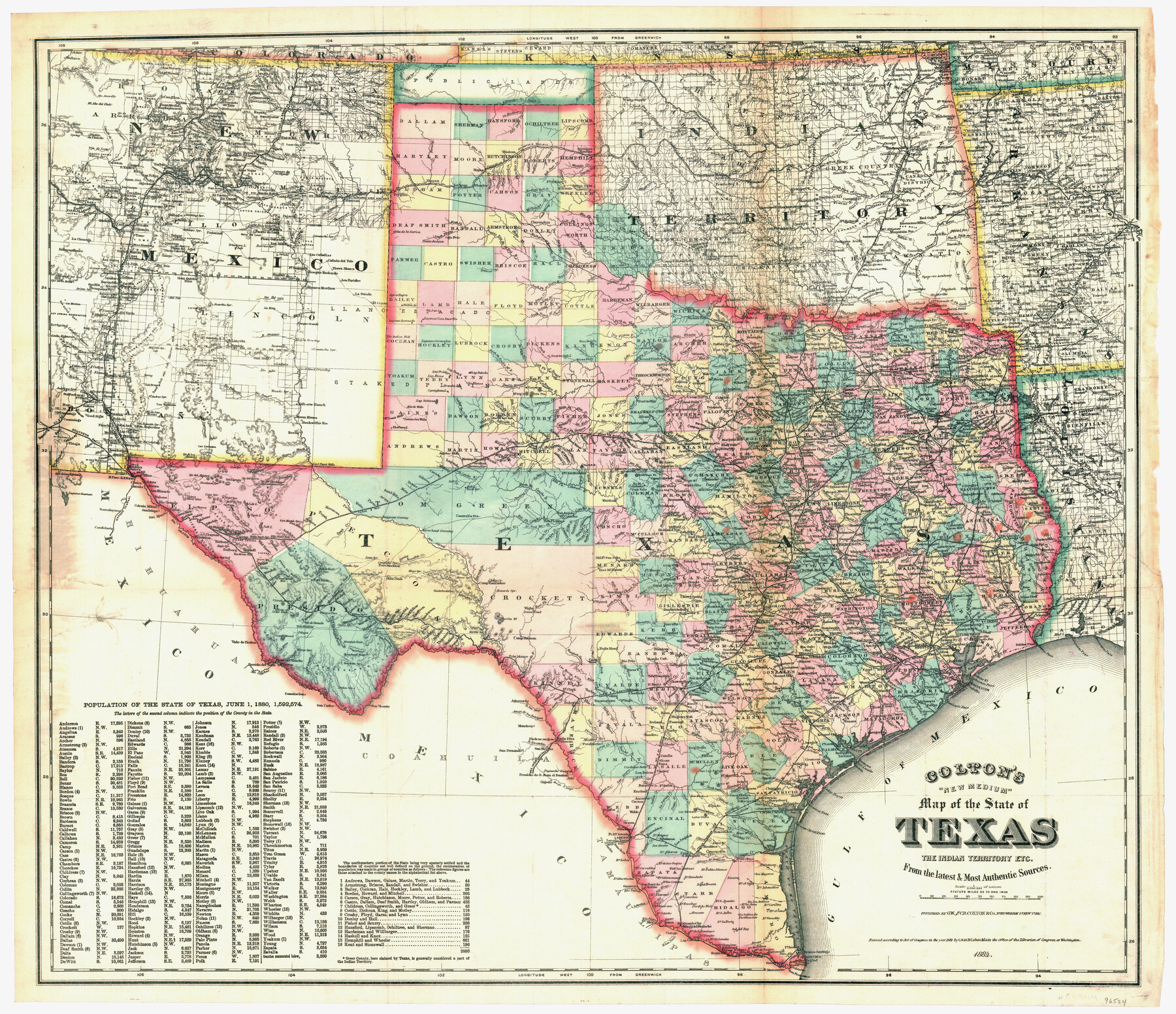
Colton's "New Medium" Map of the State of Texas, the Indian Territory, etc. from the latest & most authentic sources
- 
                          Map/Doc96524
- 
                            CollectionGeneral Map Collection
- 
                            Object Dates1884 (Creation Date)
- 
                            People and OrganizationsG.W. & C.B. Colton (Publisher)G.W. Colton (Publisher)C.B. Colton (Publisher)
- 
                            SubjectsState of Texas
- 
                            Height x Width25.4 x 29.5 inches64.5 x 74.9 cm
- 
                            Mediumpaper, etching/engraving/lithograph
- 
                            Scale1" = 33 statute miles
Part of: General Map Collection
            Wilbarger County Sketch File 5


                                            Print $4.00                    
                                             -                         Digital $50.00                                    
                Wilbarger County Sketch File 5
Size 9.3 x 7.9 inches
                                Map/Doc 40170
            
            Starr County Rolled Sketch 43


                                            Print $20.00                    
                                             -                         Digital $50.00                                    
                Starr County Rolled Sketch 43
1982
Size 36.1 x 30.9 inches
                                Map/Doc 7836
            
            [Gulf, Colorado & Santa Fe Railway Company]
            
                                    ![64410, [Gulf, Colorado & Santa Fe Railway Company], General Map Collection](https://historictexasmaps.com/wmedia_w700/maps/64410.tif.jpg) 


    ![64410, [Gulf, Colorado & Santa Fe Railway Company], General Map Collection](https://historictexasmaps.com/wmedia_w700/maps/64410.tif.jpg) 
                                
            
                                            Print $40.00                    
                                             -                         Digital $50.00                                    
                [Gulf, Colorado & Santa Fe Railway Company]
1893
Size 21.5 x 121.2 inches
                                Map/Doc 64410
            
            Washington County Sketch File 4


                                            Print $4.00                    
                                             -                         Digital $50.00                                    
                Washington County Sketch File 4
1863
Size 12.8 x 7.8 inches
                                Map/Doc 39650
            
            Map of Leon County


                                            Print $20.00                    
                                             -                         Digital $50.00                                    
                Map of Leon County
1867
Size 25.5 x 23.1 inches
                                Map/Doc 3809
            
            Borden County Sketch File 1


                                            Print $6.00                    
                                             -                         Digital $50.00                                    
                Borden County Sketch File 1
Size 16.2 x 11.0 inches
                                Map/Doc 14701
            
            Coleman County Rolled Sketch 7


                                            Print $20.00                    
                                             -                         Digital $50.00                                    
                Coleman County Rolled Sketch 7
Size 19.3 x 14.3 inches
                                Map/Doc 5530
            
            Meanders of Sulphur Fork of Red River, Red River County, Texas


                                            Print $3.00                    
                                             -                         Digital $50.00                                    
                Meanders of Sulphur Fork of Red River, Red River County, Texas
1841
Size 9.9 x 15.9 inches
                                Map/Doc 65784
            
            San Patricio County NRC Article 33.136 Sketch 9


                                            Print $82.00                    
                                    
                San Patricio County NRC Article 33.136 Sketch 9
2022
Map/Doc 97031
            
            Flight Mission No. CLL-1N, Frame 8, Willacy County


                                            Print $20.00                    
                                             -                         Digital $50.00                                    
                Flight Mission No. CLL-1N, Frame 8, Willacy County
1954
Size 18.3 x 22.1 inches
                                Map/Doc 86995
            You may also like
            Zavala County Sketch File 14


                                            Print $26.00                    
                                             -                         Digital $50.00                                    
                Zavala County Sketch File 14
1887
Size 14.4 x 8.7 inches
                                Map/Doc 41308
            
            [General Highway Map of] Bexar County, Sheet 1 of 2
            
                                    ![76288, [General Highway Map of] Bexar County, Sheet 1 of 2, Texas State Library and Archives](https://historictexasmaps.com/wmedia_w700/maps/76288.tif.jpg) 


    ![76288, [General Highway Map of] Bexar County, Sheet 1 of 2, Texas State Library and Archives](https://historictexasmaps.com/wmedia_w700/maps/76288.tif.jpg) 
                                
            
                                            Print $20.00                    
                                    
                [General Highway Map of] Bexar County, Sheet 1 of 2
1940
Size 18.5 x 25.1 inches
                                Map/Doc 76288
            
            Flight Mission No. CRC-4R, Frame 65, Chambers County


                                            Print $20.00                    
                                             -                         Digital $50.00                                    
                Flight Mission No. CRC-4R, Frame 65, Chambers County
1956
Size 18.6 x 22.4 inches
                                Map/Doc 84869
            
            Aransas County Rolled Sketch 9


                                                                    Digital $50.00                                    
                Aransas County Rolled Sketch 9
Size 85.3 x 41.9 inches
                                Map/Doc 8409
            
            Bell County Sketch File 25a


                                            Print $4.00                    
                                             -                         Digital $50.00                                    
                Bell County Sketch File 25a
1880
Size 8.9 x 10.9 inches
                                Map/Doc 14424
            
            Val Verde County Rolled Sketch 38


                                            Print $20.00                    
                                             -                         Digital $50.00                                    
                Val Verde County Rolled Sketch 38
Size 30.4 x 19.5 inches
                                Map/Doc 61781
            
            Lampasas County Boundary File 14


                                            Print $10.00                    
                                             -                         Digital $50.00                                    
                Lampasas County Boundary File 14
Size 13.3 x 8.3 inches
                                Map/Doc 56198
            
            Burnet County Rolled Sketch T


                                            Print $20.00                    
                                             -                         Digital $50.00                                    
                Burnet County Rolled Sketch T
Size 24.9 x 18.5 inches
                                Map/Doc 76053
            
            [Sketch of 'San Salvador del Tule', Juan Jose Balli Grant, Hidalgo County, Texas]
            
                                    ![10756, [Sketch of 'San Salvador del Tule', Juan Jose Balli Grant, Hidalgo County, Texas], Maddox Collection](https://historictexasmaps.com/wmedia_w700/maps/10756.tif.jpg) 


    ![10756, [Sketch of 'San Salvador del Tule', Juan Jose Balli Grant, Hidalgo County, Texas], Maddox Collection](https://historictexasmaps.com/wmedia_w700/maps/10756.tif.jpg) 
                                
            
                                            Print $20.00                    
                                             -                         Digital $50.00                                    
                [Sketch of 'San Salvador del Tule', Juan Jose Balli Grant, Hidalgo County, Texas]
Size 22.0 x 17.5 inches
                                Map/Doc 10756
            
            Howard County Sketch File 16


                                            Print $40.00                    
                                             -                         Digital $50.00                                    
                Howard County Sketch File 16
1947
Size 19.7 x 9.0 inches
                                Map/Doc 26878
            
            Hall County Boundary File 1


                                            Print $26.00                    
                                             -                         Digital $50.00                                    
                Hall County Boundary File 1
Size 8.8 x 4.0 inches
                                Map/Doc 54158
            
            United States Bathymetric and Fishing Maps including Topographic/Bathymetric Maps


                                            Print $40.00                    
                                             -                         Digital $50.00                                    
                United States Bathymetric and Fishing Maps including Topographic/Bathymetric Maps
1992
Size 21.5 x 54.9 inches
                                Map/Doc 76128
             
                         
                                