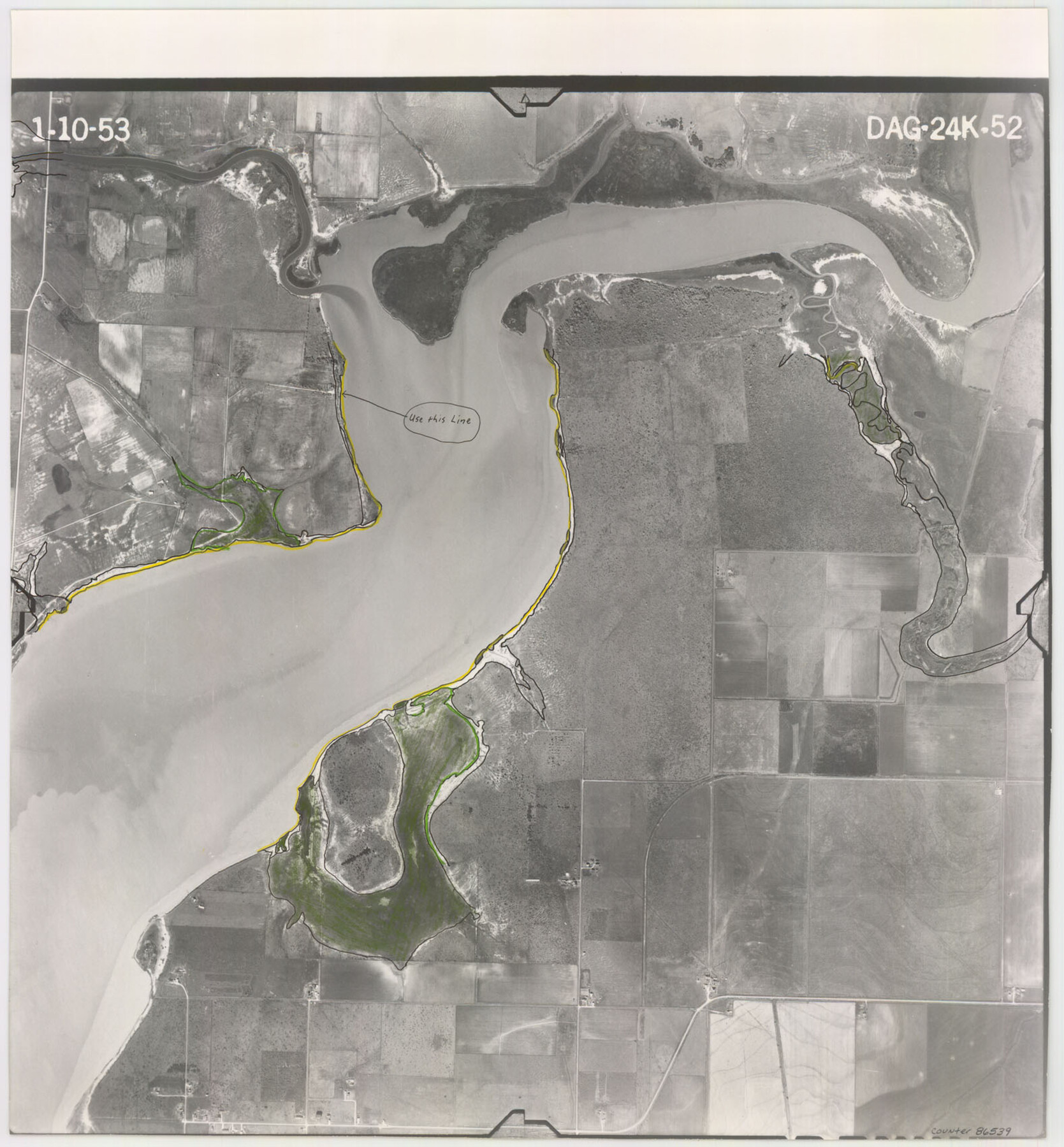
Flight Mission No. DAG-24K, Frame 52, Matagorda County
DAG-24K-52
-
Map/Doc
86539
-
Collection
General Map Collection
-
Object Dates
1953/1/10 (Creation Date)
-
People and Organizations
U. S. Department of Agriculture (Publisher)
-
Counties
Matagorda
-
Subjects
Aerial Photograph
-
Height x Width
17.0 x 15.8 inches
43.2 x 40.1 cm
-
Comments
Flown by Aero Exploration Company of Tulsa, Oklahoma.
Part of: General Map Collection
Presidio County Rolled Sketch 53

Print $20.00
- Digital $50.00
Presidio County Rolled Sketch 53
1911
Size 14.3 x 21.7 inches
Map/Doc 7345
Navarro County Sketch File 5

Print $6.00
- Digital $50.00
Navarro County Sketch File 5
1852
Size 5.5 x 8.1 inches
Map/Doc 32307
[Surveys along the Medina River]
![52, [Surveys along the Medina River], General Map Collection](https://historictexasmaps.com/wmedia_w700/maps/52.tif.jpg)
Print $2.00
- Digital $50.00
[Surveys along the Medina River]
1840
Size 8.2 x 14.3 inches
Map/Doc 52
Goliad County Working Sketch 11

Print $20.00
- Digital $50.00
Goliad County Working Sketch 11
1941
Size 38.8 x 40.8 inches
Map/Doc 63201
Tom Green County Sketch File 37

Print $2.00
- Digital $50.00
Tom Green County Sketch File 37
Size 9.4 x 8.5 inches
Map/Doc 38195
Kendall County Sketch File 27

Print $6.00
- Digital $50.00
Kendall County Sketch File 27
1950
Size 12.4 x 10.9 inches
Map/Doc 28731
Taylor County Sketch File 21

Print $10.00
- Digital $50.00
Taylor County Sketch File 21
1962
Size 11.3 x 8.8 inches
Map/Doc 37821
Old Miscellaneous File 37

Print $4.00
- Digital $50.00
Old Miscellaneous File 37
1912
Size 11.2 x 8.8 inches
Map/Doc 75280
Flight Mission No. DQO-8K, Frame 55, Galveston County

Print $20.00
- Digital $50.00
Flight Mission No. DQO-8K, Frame 55, Galveston County
1952
Size 18.7 x 22.5 inches
Map/Doc 85162
Moore County Rolled Sketch 13

Print $20.00
- Digital $50.00
Moore County Rolled Sketch 13
1920
Size 25.8 x 33.3 inches
Map/Doc 6829
[Sketch of surveys in the Bexar District along the Pedernales River]
![103, [Sketch of surveys in the Bexar District along the Pedernales River], General Map Collection](https://historictexasmaps.com/wmedia_w700/maps/103-1.tif.jpg)
Print $2.00
- Digital $50.00
[Sketch of surveys in the Bexar District along the Pedernales River]
1847
Size 13.6 x 8.3 inches
Map/Doc 103
Marion County Rolled Sketch 10

Print $20.00
- Digital $50.00
Marion County Rolled Sketch 10
2023
Size 24.1 x 36.9 inches
Map/Doc 97192
You may also like
Cameron County Rolled Sketch 25

Print $20.00
- Digital $50.00
Cameron County Rolled Sketch 25
1977
Size 17.5 x 27.5 inches
Map/Doc 5790
Travis County Sketch File 51

Print $8.00
- Digital $50.00
Travis County Sketch File 51
1941
Size 14.3 x 8.9 inches
Map/Doc 38387
Outer Continental Shelf Leasing Maps (Louisiana Offshore Operations)

Print $20.00
- Digital $50.00
Outer Continental Shelf Leasing Maps (Louisiana Offshore Operations)
1955
Size 19.9 x 13.4 inches
Map/Doc 75860
Delta County Working Sketch 3

Print $20.00
- Digital $50.00
Delta County Working Sketch 3
1963
Size 24.9 x 24.4 inches
Map/Doc 68640
Brazos County Working Sketch 6

Print $20.00
- Digital $50.00
Brazos County Working Sketch 6
1979
Size 29.4 x 20.5 inches
Map/Doc 67481
Presidio County Rolled Sketch 143

Print $20.00
- Digital $50.00
Presidio County Rolled Sketch 143
Size 40.2 x 36.8 inches
Map/Doc 90046
Sketches of Surveys in Jefferson County

Print $2.00
- Digital $50.00
Sketches of Surveys in Jefferson County
1841
Size 7.5 x 7.0 inches
Map/Doc 326
Webb County Working Sketch 44

Print $20.00
- Digital $50.00
Webb County Working Sketch 44
1943
Size 26.0 x 27.4 inches
Map/Doc 72409
Land for Sale or Lease in Garza and Crosby County, 13 miles S 10° W from center of Crosby County

Print $2.00
- Digital $50.00
Land for Sale or Lease in Garza and Crosby County, 13 miles S 10° W from center of Crosby County
Size 9.0 x 14.3 inches
Map/Doc 90367
Floyd County Sketch File 29

Print $20.00
- Digital $50.00
Floyd County Sketch File 29
Size 17.0 x 16.5 inches
Map/Doc 11488
Wharton County Sketch File 4a

Print $4.00
- Digital $50.00
Wharton County Sketch File 4a
1876
Size 12.7 x 8.1 inches
Map/Doc 39919
Red River County Rolled Sketch 11

Print $40.00
- Digital $50.00
Red River County Rolled Sketch 11
2006
Size 36.8 x 48.6 inches
Map/Doc 88614