Old Miscellaneous File 37
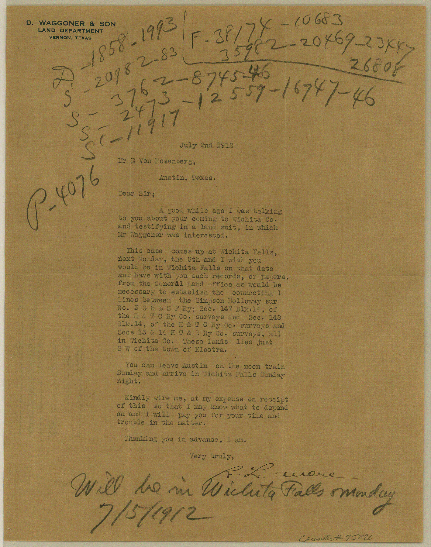
Letter regarding land suit on tracts southwest of Elektra
-
Map/Doc
75280
-
Collection
General Map Collection
-
Object Dates
1912/7/2 (Creation Date)
1985/2/8 (File Date)
-
People and Organizations
R.L. Lemere (Author)
-
Subjects
Legal
-
Height x Width
11.2 x 8.8 inches
28.5 x 22.4 cm
Part of: General Map Collection
International Boundary Line in the Rio Grande delineated in accordance with the Treaty of 1970 - (1982/1983 Aerial Photographs)

International Boundary Line in the Rio Grande delineated in accordance with the Treaty of 1970 - (1982/1983 Aerial Photographs)
1982
Map/Doc 74827
Brewster County Working Sketch 114

Print $20.00
- Digital $50.00
Brewster County Working Sketch 114
1983
Size 36.0 x 31.7 inches
Map/Doc 67714
Right of Way and Track Map of The Missouri, Kansas & Texas Railway of Texas

Print $40.00
- Digital $50.00
Right of Way and Track Map of The Missouri, Kansas & Texas Railway of Texas
1918
Size 25.2 x 51.6 inches
Map/Doc 64530
Culberson County Sketch File 22

Print $6.00
- Digital $50.00
Culberson County Sketch File 22
1934
Size 11.8 x 8.8 inches
Map/Doc 20234

Fisher County

Print $20.00
- Digital $50.00
Fisher County
1921
Size 45.2 x 41.0 inches
Map/Doc 16829
Jim Hogg Co. / Brooks Co.

Print $20.00
- Digital $50.00
Jim Hogg Co. / Brooks Co.
1912
Size 33.0 x 43.6 inches
Map/Doc 4894
Padre Island National Seashore

Print $4.00
- Digital $50.00
Padre Island National Seashore
Size 16.1 x 22.1 inches
Map/Doc 60531
Hudspeth County Working Sketch 21

Print $20.00
- Digital $50.00
Hudspeth County Working Sketch 21
1966
Size 22.8 x 41.6 inches
Map/Doc 66303
Reeves County Boundary File 1

Print $12.00
- Digital $50.00
Reeves County Boundary File 1
Size 14.1 x 8.5 inches
Map/Doc 58195
Goliad County Sketch File 37

Print $4.00
- Digital $50.00
Goliad County Sketch File 37
1850
Size 10.2 x 8.3 inches
Map/Doc 24336
Bosque County Sketch File 14

Print $22.00
- Digital $50.00
Bosque County Sketch File 14
1863
Size 12.2 x 7.6 inches
Map/Doc 14763
You may also like
Flight Mission No. DQO-3K, Frame 28, Galveston County

Print $20.00
- Digital $50.00
Flight Mission No. DQO-3K, Frame 28, Galveston County
1952
Size 18.1 x 22.3 inches
Map/Doc 85069
Culberson County Working Sketch 66

Print $40.00
- Digital $50.00
Culberson County Working Sketch 66
1975
Size 52.1 x 33.2 inches
Map/Doc 68520

Williamson County Boundary File 3

Print $20.00
- Digital $50.00
Williamson County Boundary File 3
Size 18.5 x 23.6 inches
Map/Doc 60012
Travis County Sketch File 20

Print $4.00
- Digital $50.00
Travis County Sketch File 20
Size 11.0 x 8.8 inches
Map/Doc 38323
[Sketch for Mineral Application 17237 / Mineral File 11855 - Neches River, Joe A. Sanders]
![65687, [Sketch for Mineral Application 17237 / Mineral File 11855 - Neches River, Joe A. Sanders], General Map Collection](https://historictexasmaps.com/wmedia_w700/maps/65687.tif.jpg)
Print $40.00
- Digital $50.00
[Sketch for Mineral Application 17237 / Mineral File 11855 - Neches River, Joe A. Sanders]
1927
Size 78.5 x 31.2 inches
Map/Doc 65687
Starr County Sketch File 24

Print $20.00
- Digital $50.00
Starr County Sketch File 24
1922
Size 15.7 x 19.5 inches
Map/Doc 12332
Topographical Map of the Rio Grande, Sheet No. 19

Print $20.00
- Digital $50.00
Topographical Map of the Rio Grande, Sheet No. 19
1912
Map/Doc 89543
Aransas County Sketch File 27

Print $23.00
- Digital $50.00
Aransas County Sketch File 27
Size 12.2 x 18.2 inches
Map/Doc 13224
San Patricio County Working Sketch 10

Print $20.00
- Digital $50.00
San Patricio County Working Sketch 10
1939
Size 28.1 x 32.6 inches
Map/Doc 63772
Dimmit County Sketch File 11

Print $12.00
- Digital $50.00
Dimmit County Sketch File 11
1880
Size 12.9 x 8.2 inches
Map/Doc 21075
Andrews County

Print $40.00
- Digital $50.00
Andrews County
1925
Size 42.6 x 57.1 inches
Map/Doc 66703