Burnet County Sketch File 36
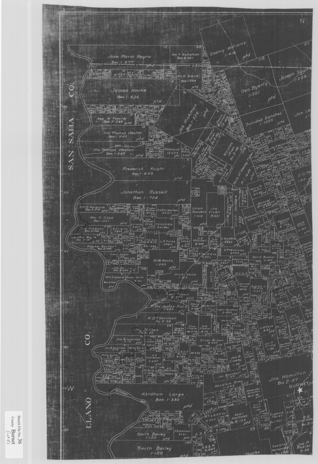
[Copy of northwestern part of GLO map of Burnet County and USGS topographic map showing the area of Lake Buchanan]
-
Map/Doc
11025
-
Collection
General Map Collection
-
Object Dates
1935/3/14 (Creation Date)
-
People and Organizations
Paul McCombs (Surveyor/Engineer)
-
Counties
Burnet Llano
-
Subjects
Surveying Sketch File
-
Height x Width
25.7 x 17.6 inches
65.3 x 44.7 cm
-
Medium
multi-page, multi-format
-
Scale
1" = 2000 varas
-
Features
Deer Creek
Morgans Creek
Burnet
Ware Bluff
Colorado River
Cowan Creek
Bluffton Cemetery
Bluffton School
Lion Creek
Saltworks Ford
Baldy Mountain
Lion Mountain
Baringer Hill
Redrock Creek
Niggerhead Mountain
Part of: General Map Collection
Dickens County Sketch File 1

Print $20.00
- Digital $50.00
Dickens County Sketch File 1
1879
Size 18.2 x 15.5 inches
Map/Doc 11315
Jasper County Working Sketch 22

Print $20.00
- Digital $50.00
Jasper County Working Sketch 22
1943
Size 21.0 x 15.4 inches
Map/Doc 66484
Bell County Sketch File 1

Print $40.00
- Digital $50.00
Bell County Sketch File 1
1847
Size 14.7 x 12.4 inches
Map/Doc 14365
Texas and Mexico showing Houston and Texas Central System of Railways

Print $20.00
- Digital $50.00
Texas and Mexico showing Houston and Texas Central System of Railways
1885
Size 29.0 x 21.6 inches
Map/Doc 94274
Kent County Boundary File 3

Print $8.00
- Digital $50.00
Kent County Boundary File 3
Size 11.2 x 8.6 inches
Map/Doc 55824
Kinney County Working Sketch 16

Print $20.00
- Digital $50.00
Kinney County Working Sketch 16
1946
Size 46.3 x 37.7 inches
Map/Doc 70198
Reagan County Sketch File 30

Print $20.00
- Digital $50.00
Reagan County Sketch File 30
1951
Size 27.4 x 20.3 inches
Map/Doc 12226
Austin County

Print $20.00
- Digital $50.00
Austin County
1943
Size 40.1 x 42.5 inches
Map/Doc 73073
Red River County Working Sketch 61

Print $20.00
- Digital $50.00
Red River County Working Sketch 61
1973
Size 37.8 x 38.5 inches
Map/Doc 72044
Nueces County Sketch File 69

Print $6.00
- Digital $50.00
Nueces County Sketch File 69
Size 11.1 x 8.7 inches
Map/Doc 33004
Pecos County Working Sketch 131

Print $20.00
- Digital $50.00
Pecos County Working Sketch 131
1977
Size 27.8 x 21.1 inches
Map/Doc 71605

You may also like
General Highway Map, Lavaca County, Texas

Print $20.00
General Highway Map, Lavaca County, Texas
1961
Size 24.6 x 18.1 inches
Map/Doc 79566
Kerr County Rolled Sketch 21

Print $20.00
- Digital $50.00
Kerr County Rolled Sketch 21
1959
Size 44.5 x 30.5 inches
Map/Doc 9348
Glasscock County Sketch File 18

Print $8.00
- Digital $50.00
Glasscock County Sketch File 18
1931
Size 9.7 x 6.2 inches
Map/Doc 24192
Comal County Sketch File 1

Print $6.00
- Digital $50.00
Comal County Sketch File 1
1846
Size 16.4 x 10.5 inches
Map/Doc 18995
Rusk County Working Sketch 6

Print $20.00
- Digital $50.00
Rusk County Working Sketch 6
1982
Size 32.8 x 32.9 inches
Map/Doc 63641
University of Texas System University Lands

Print $20.00
- Digital $50.00
University of Texas System University Lands
1972
Size 23.2 x 17.9 inches
Map/Doc 93250
Map of Menard County

Print $20.00
- Digital $50.00
Map of Menard County
1871
Size 18.5 x 23.3 inches
Map/Doc 3872
Coleman County Sketch File 20

Print $4.00
- Digital $50.00
Coleman County Sketch File 20
1871
Size 12.9 x 8.0 inches
Map/Doc 18694
Foard County Sketch File 9

Print $20.00
- Digital $50.00
Foard County Sketch File 9
1882
Size 19.7 x 17.1 inches
Map/Doc 11492
Webb County Sketch File 9c

Print $20.00
- Digital $50.00
Webb County Sketch File 9c
1930
Size 18.7 x 22.1 inches
Map/Doc 12621
Hardin County Sketch File 59

Print $6.00
- Digital $50.00
Hardin County Sketch File 59
Size 16.8 x 11.6 inches
Map/Doc 25233
Kinney County Sketch File 31

Print $40.00
- Digital $50.00
Kinney County Sketch File 31
1934
Size 15.3 x 13.6 inches
Map/Doc 29176