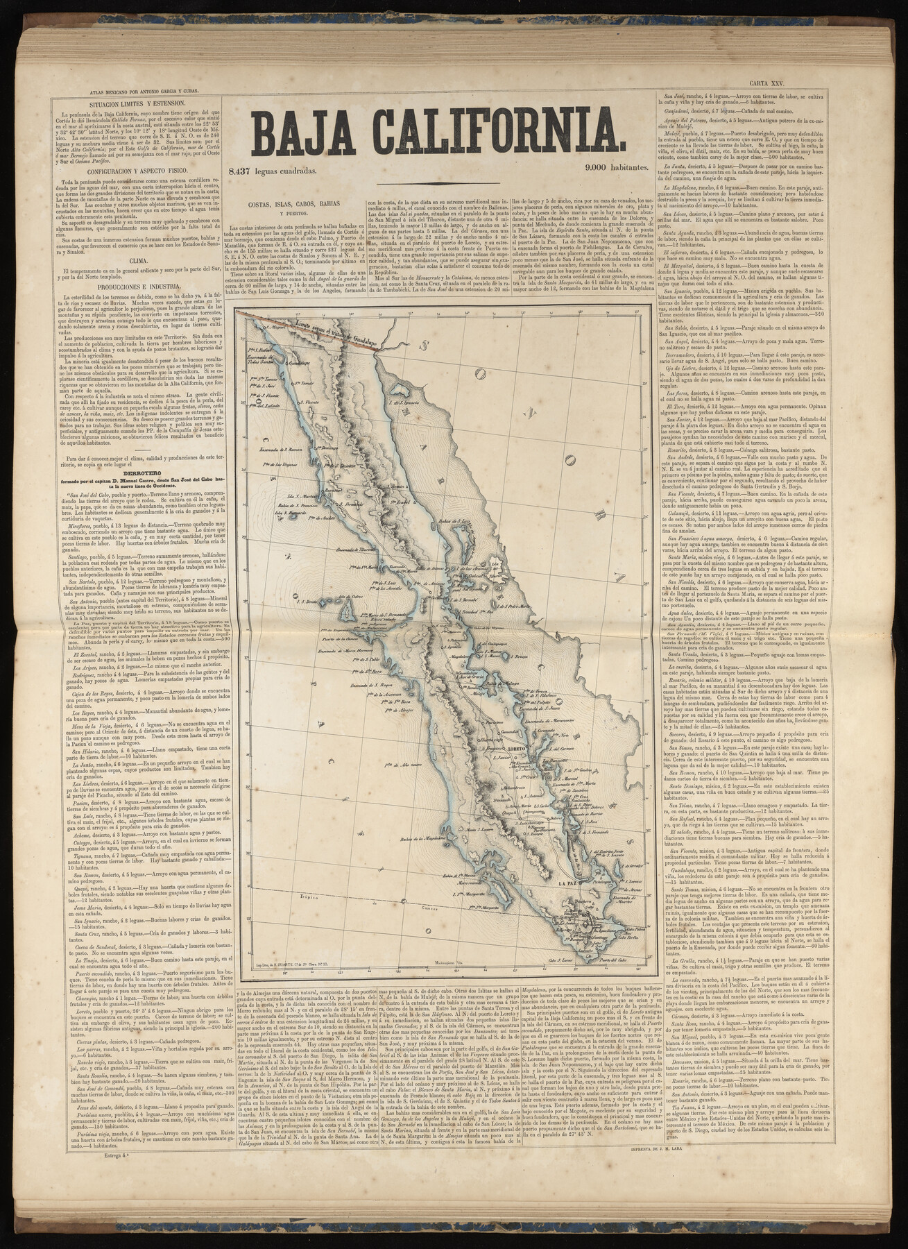
Baja California
-
Map/Doc
97007
-
Collection
General Map Collection
-
Object Dates
1858 (Publication Date)
-
People and Organizations
Antonio García y Cubas (Cartographer)
-
Subjects
Atlas Mexico
-
Height x Width
31.5 x 22.9 inches
80.0 x 58.2 cm
-
Medium
paper, etching/engraving/lithograph
-
Comments
Map 26 of 32 from "Atlas Geografico, Estadistico e Historico de la Republica Mexicana" (95689)
Related maps
Atlas Geográfico, Estadístico é Histórico de la República Mexicana

Atlas Geográfico, Estadístico é Histórico de la República Mexicana
Map/Doc 95689
Part of: General Map Collection
Atascosa County Working Sketch 37

Print $20.00
- Digital $50.00
Atascosa County Working Sketch 37
2004
Size 23.2 x 24.1 inches
Map/Doc 89049
Presidio County Rolled Sketch 59

Print $20.00
- Digital $50.00
Presidio County Rolled Sketch 59
Size 27.6 x 18.2 inches
Map/Doc 7352
Terrell County

Print $20.00
- Digital $50.00
Terrell County
1905
Size 40.5 x 32.3 inches
Map/Doc 4075
Austin County Rolled Sketch 5A

Print $40.00
- Digital $50.00
Austin County Rolled Sketch 5A
Size 54.2 x 44.1 inches
Map/Doc 8437
Denton County Boundary File 3

Print $34.00
- Digital $50.00
Denton County Boundary File 3
Size 6.1 x 3.9 inches
Map/Doc 52424
Robertson County Rolled Sketch 1

Print $20.00
- Digital $50.00
Robertson County Rolled Sketch 1
1966
Size 45.5 x 28.9 inches
Map/Doc 9862
Duval County Sketch File 66

Print $12.00
- Digital $50.00
Duval County Sketch File 66
1944
Size 14.5 x 8.8 inches
Map/Doc 21444
Howard County Working Sketch 10

Print $20.00
- Digital $50.00
Howard County Working Sketch 10
1962
Size 24.4 x 26.1 inches
Map/Doc 66278
Brewster County Sketch File 24

Print $40.00
- Digital $50.00
Brewster County Sketch File 24
1957
Size 14.3 x 15.5 inches
Map/Doc 15831
Flight Mission No. BRE-2P, Frame 109, Nueces County

Print $20.00
- Digital $50.00
Flight Mission No. BRE-2P, Frame 109, Nueces County
1956
Size 18.6 x 22.5 inches
Map/Doc 86794
East Part of Jeff Davis Co.

Print $20.00
- Digital $50.00
East Part of Jeff Davis Co.
1977
Size 46.4 x 35.7 inches
Map/Doc 73194
Flight Mission No. DCL-6C, Frame 28, Kenedy County

Print $20.00
- Digital $50.00
Flight Mission No. DCL-6C, Frame 28, Kenedy County
1943
Size 18.7 x 22.4 inches
Map/Doc 85885
You may also like
Clay County Boundary File 11

Print $12.00
- Digital $50.00
Clay County Boundary File 11
Size 14.0 x 8.4 inches
Map/Doc 51400
Flight Mission No. DIX-8P, Frame 91, Aransas County

Print $20.00
- Digital $50.00
Flight Mission No. DIX-8P, Frame 91, Aransas County
1956
Size 18.5 x 22.4 inches
Map/Doc 83916
Presidio County Working Sketch 86

Print $20.00
- Digital $50.00
Presidio County Working Sketch 86
1971
Size 45.4 x 42.2 inches
Map/Doc 71763
Travis County Appraisal District Plat Map 3_0104

Print $20.00
- Digital $50.00
Travis County Appraisal District Plat Map 3_0104
Size 21.5 x 26.4 inches
Map/Doc 94224
Walker County Working Sketch 7

Print $20.00
- Digital $50.00
Walker County Working Sketch 7
1935
Size 38.3 x 43.2 inches
Map/Doc 72287
Childress Co.

Print $20.00
- Digital $50.00
Childress Co.
1978
Size 47.3 x 36.0 inches
Map/Doc 95454
Flight Mission No. BQR-9K, Frame 12, Brazoria County

Print $20.00
- Digital $50.00
Flight Mission No. BQR-9K, Frame 12, Brazoria County
1952
Size 18.8 x 22.3 inches
Map/Doc 84041
Bastrop County

Print $20.00
- Digital $50.00
Bastrop County
1879
Size 21.5 x 19.5 inches
Map/Doc 3277
Hunt County Sketch File 33

Print $4.00
- Digital $50.00
Hunt County Sketch File 33
1864
Size 7.1 x 5.0 inches
Map/Doc 27141
Map of San Patricio County

Print $20.00
- Digital $50.00
Map of San Patricio County
1863
Size 17.9 x 26.3 inches
Map/Doc 4018
Starr County Sketch File 6

Print $20.00
- Digital $50.00
Starr County Sketch File 6
Size 43.4 x 36.7 inches
Map/Doc 10605
