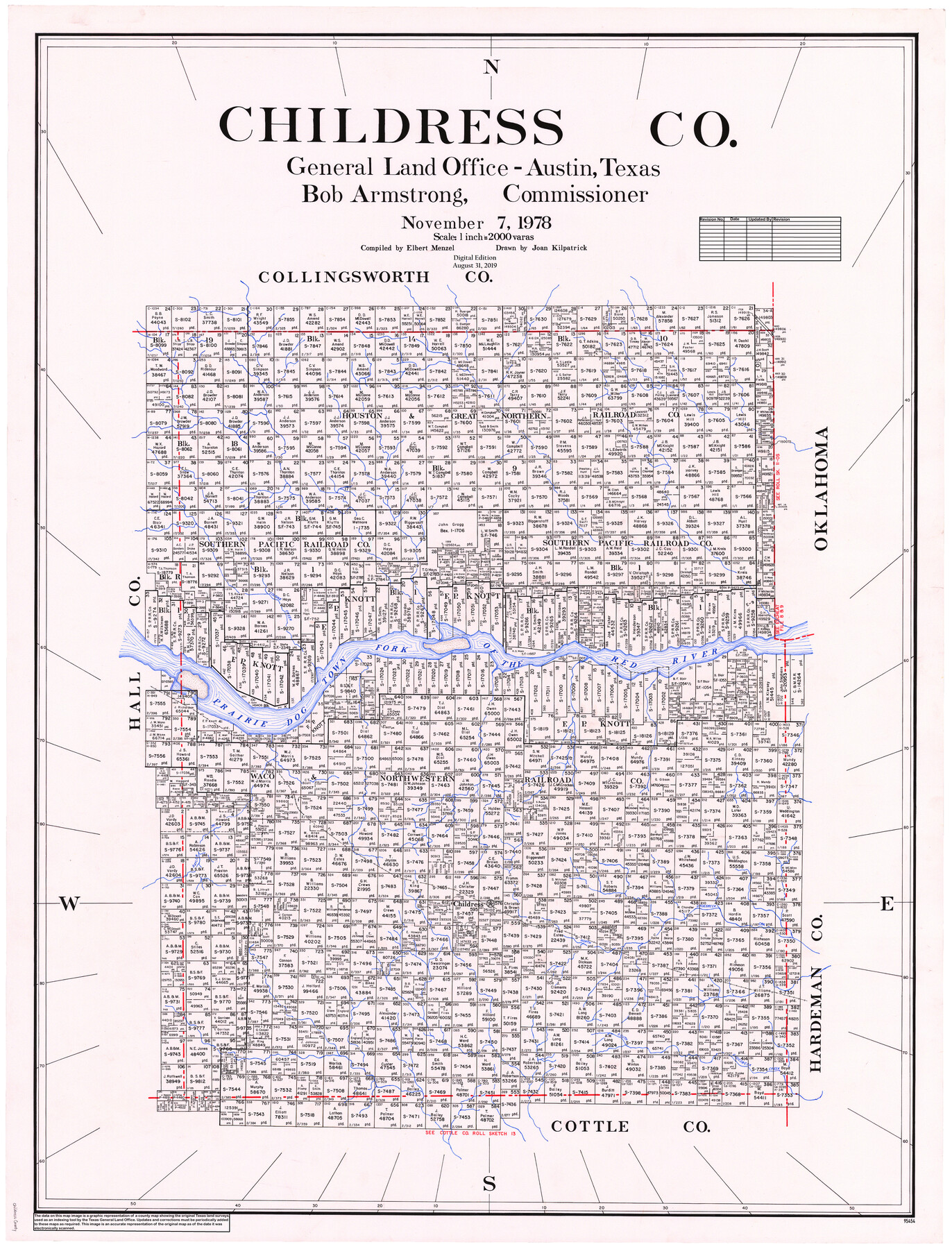
Childress Co.
General Land Office Official County Map
-
Map/Doc
95454
-
Collection
General Map Collection
-
Object Dates
2019/8/31 (Revision Date)
1978/11/7 (Creation Date)
-
People and Organizations
Cheyenne Betancourt (Draftsman)
Joan Kilpatrick (Draftsman)
Elbert Menzel (Compiler)
Bob Armstrong (GLO Commissioner)
-
Counties
Childress
-
Subjects
County OCM
-
Height x Width
47.3 x 36.0 inches
120.1 x 91.4 cm
-
Medium
digital image
-
Scale
1" = 2000 varas
Part of: General Map Collection
Flight Mission No. BRA-8M, Frame 84, Jefferson County

Print $20.00
- Digital $50.00
Flight Mission No. BRA-8M, Frame 84, Jefferson County
1953
Size 18.6 x 22.4 inches
Map/Doc 85604
Galveston - Texas City, Texas

Galveston - Texas City, Texas
2008
Size 26.9 x 39.0 inches
Map/Doc 96858
Henderson County Rolled Sketch 12

Print $20.00
- Digital $50.00
Henderson County Rolled Sketch 12
1980
Size 22.8 x 19.1 inches
Map/Doc 6204
Baylor County Sketch File Z5

Print $4.00
- Digital $50.00
Baylor County Sketch File Z5
1902
Size 11.5 x 8.9 inches
Map/Doc 14115
[Blocks 341, G-5, G-12, TCRRCo.]
![60298, [Blocks 341, G-5, G-12, TCRRCo.], General Map Collection](https://historictexasmaps.com/wmedia_w700/maps/60298-1.tif.jpg)
Print $20.00
- Digital $50.00
[Blocks 341, G-5, G-12, TCRRCo.]
1954
Size 15.1 x 26.1 inches
Map/Doc 60298
[Map of Nacogdoches County]
![93369, [Map of Nacogdoches County], General Map Collection](https://historictexasmaps.com/wmedia_w700/maps/93369-1.tif.jpg)
Print $40.00
- Digital $50.00
[Map of Nacogdoches County]
1840
Size 79.3 x 36.8 inches
Map/Doc 93369
Flight Mission No. DQN-4K, Frame 3, Calhoun County

Print $20.00
- Digital $50.00
Flight Mission No. DQN-4K, Frame 3, Calhoun County
1953
Size 18.9 x 22.4 inches
Map/Doc 84368
Flight Mission No. BRA-17M, Frame 8, Jefferson County

Print $20.00
- Digital $50.00
Flight Mission No. BRA-17M, Frame 8, Jefferson County
1953
Size 18.6 x 22.3 inches
Map/Doc 85789
Red River County Sketch File 24

Print $6.00
- Digital $50.00
Red River County Sketch File 24
1920
Size 11.4 x 8.8 inches
Map/Doc 35158
Jefferson County Rolled Sketch 60

Print $20.00
- Digital $50.00
Jefferson County Rolled Sketch 60
1885
Size 31.0 x 35.6 inches
Map/Doc 9315
Runnels County

Print $40.00
- Digital $50.00
Runnels County
1948
Size 48.8 x 38.8 inches
Map/Doc 73278
Wilbarger Co.

Print $40.00
- Digital $50.00
Wilbarger Co.
1907
Size 48.8 x 39.8 inches
Map/Doc 63127
You may also like
Forester Cemetery

Print $20.00
- Digital $50.00
Forester Cemetery
1925
Size 23.0 x 28.8 inches
Map/Doc 92322
Victoria County Working Sketch 3

Print $20.00
- Digital $50.00
Victoria County Working Sketch 3
1939
Size 14.0 x 18.3 inches
Map/Doc 72273
Titus County Working Sketch 2

Print $20.00
- Digital $50.00
Titus County Working Sketch 2
Size 23.6 x 25.3 inches
Map/Doc 69363
Chambers County Sketch File 27

Print $12.00
- Digital $50.00
Chambers County Sketch File 27
1934
Size 11.3 x 8.8 inches
Map/Doc 17606
Andrews County Working Sketch 26

Print $20.00
- Digital $50.00
Andrews County Working Sketch 26
1983
Size 34.3 x 37.5 inches
Map/Doc 67072
Edwards County Working Sketch 17

Print $20.00
- Digital $50.00
Edwards County Working Sketch 17
1930
Size 32.3 x 26.8 inches
Map/Doc 68893
Pecos County Sketch File 112

Print $16.00
- Digital $50.00
Pecos County Sketch File 112
1892
Size 11.2 x 8.6 inches
Map/Doc 34061
Right of Way and Track Map, The Wichita Falls & Southern Railway

Print $40.00
- Digital $50.00
Right of Way and Track Map, The Wichita Falls & Southern Railway
1942
Size 25.5 x 92.5 inches
Map/Doc 64513
Harris County Working Sketch 127

Print $20.00
- Digital $50.00
Harris County Working Sketch 127
1996
Size 20.7 x 26.0 inches
Map/Doc 66019
Henderson County Sketch File 10

Print $4.00
- Digital $50.00
Henderson County Sketch File 10
1859
Size 12.8 x 8.3 inches
Map/Doc 26346

Tarrant County Sketch File 21a

Print $4.00
- Digital $50.00
Tarrant County Sketch File 21a
1859
Size 8.0 x 8.1 inches
Map/Doc 37727