Fort Bend County State Real Property Sketch 6
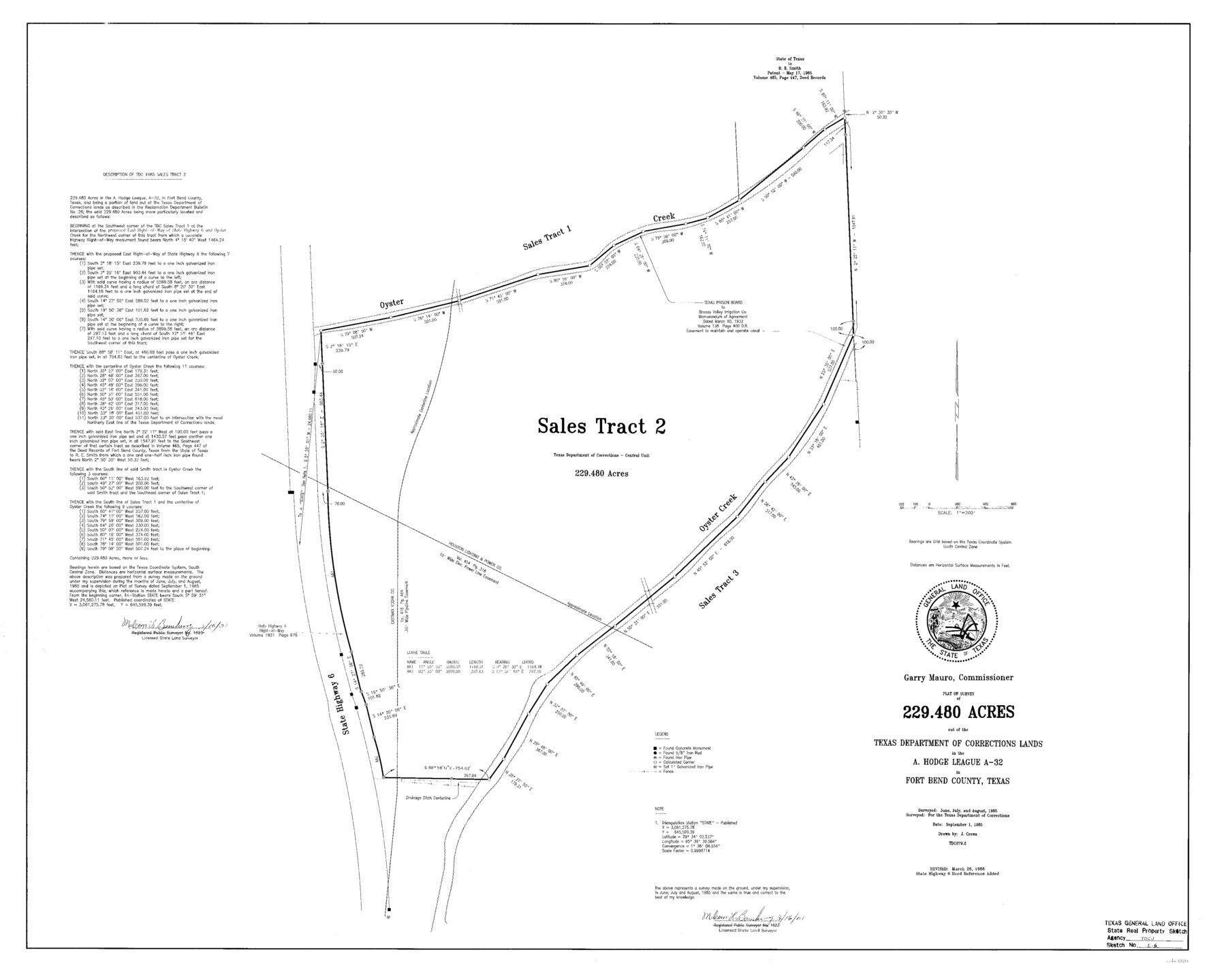
A Plat of a Survey of 229.480 Acres Out of the Texas Department of Corrections Lands, Central Unit, in the A. Hodge League, A - 32, Sales Tract 2
State Real Property Sketch S - 6
-
Map/Doc
61680
-
Collection
General Map Collection
-
Object Dates
1986/3/26 (Creation Date)
-
People and Organizations
Texas General Land Office (Publisher)
Texas General Land Office (Printer)
J. Crews (Draftsman)
J. Crews (Compiler)
Garry Mauro (GLO Commissioner)
Malcom L. Bamburg (Surveyor/Engineer)
-
Counties
Fort Bend
-
Subjects
State Real Property
-
Height x Width
34.9 x 43.6 inches
88.6 x 110.7 cm
-
Comments
Surveyed in June, July, and August 1985.
Revised March 26, 1986 with State Highway 6 Deed reference added.
Surveys located about eight miles North 67 degrees East of Richmond, Texas.
Part of: General Map Collection
Upton County Rolled Sketch 36

Print $40.00
- Digital $50.00
Upton County Rolled Sketch 36
1952
Size 42.9 x 64.2 inches
Map/Doc 10051
Wharton County Working Sketch 25

Print $20.00
- Digital $50.00
Wharton County Working Sketch 25
1993
Size 20.0 x 25.5 inches
Map/Doc 72489
Runnels County Rolled Sketch 27

Print $20.00
- Digital $50.00
Runnels County Rolled Sketch 27
1928
Size 20.0 x 39.6 inches
Map/Doc 7515
Guadalupe County Sketch File 11

Print $4.00
- Digital $50.00
Guadalupe County Sketch File 11
Size 8.0 x 12.8 inches
Map/Doc 24681
Montague County Working Sketch 29

Print $20.00
- Digital $50.00
Montague County Working Sketch 29
1972
Size 27.8 x 22.1 inches
Map/Doc 71095
Kimble County Working Sketch 59

Print $20.00
- Digital $50.00
Kimble County Working Sketch 59
1963
Size 24.6 x 40.8 inches
Map/Doc 70127
Morris County Rolled Sketch 2A

Print $20.00
- Digital $50.00
Morris County Rolled Sketch 2A
Size 24.0 x 18.8 inches
Map/Doc 10226
Brazoria County Working Sketch 28

Print $20.00
- Digital $50.00
Brazoria County Working Sketch 28
1971
Size 23.8 x 17.2 inches
Map/Doc 67513
Runnels County Sketch File 18

Print $10.00
Runnels County Sketch File 18
1892
Size 14.0 x 8.4 inches
Map/Doc 35476
Wheeler County Working Sketch 5

Print $40.00
- Digital $50.00
Wheeler County Working Sketch 5
1972
Size 55.3 x 45.9 inches
Map/Doc 72494
Haskell County Boundary File 5

Print $80.00
- Digital $50.00
Haskell County Boundary File 5
Size 16.5 x 11.9 inches
Map/Doc 54578
Matagorda County Rolled Sketch PHL1

Print $20.00
- Digital $50.00
Matagorda County Rolled Sketch PHL1
Size 36.5 x 39.1 inches
Map/Doc 9477
You may also like
Reagan County Working Sketch 30

Print $40.00
- Digital $50.00
Reagan County Working Sketch 30
1963
Size 31.9 x 57.3 inches
Map/Doc 71872
Stephens County Sketch File 20

Print $20.00
- Digital $50.00
Stephens County Sketch File 20
Size 19.2 x 36.7 inches
Map/Doc 12350
Castro County Sketch File 1a

Print $8.00
- Digital $50.00
Castro County Sketch File 1a
Size 8.6 x 14.0 inches
Map/Doc 17454
[Blocks 341, G-5, G-12, TCRRCo.]
![2069, [Blocks 341, G-5, G-12, TCRRCo.], General Map Collection](https://historictexasmaps.com/wmedia_w700/maps/2069-1.tif.jpg)
Print $20.00
- Digital $50.00
[Blocks 341, G-5, G-12, TCRRCo.]
1954
Size 23.7 x 22.7 inches
Map/Doc 2069
Flight Mission No. DQN-7K, Frame 33, Calhoun County

Print $20.00
- Digital $50.00
Flight Mission No. DQN-7K, Frame 33, Calhoun County
1953
Size 18.5 x 22.1 inches
Map/Doc 84471
King County Sketch File 10

Print $24.00
- Digital $50.00
King County Sketch File 10
1902
Size 14.2 x 8.7 inches
Map/Doc 29083
[Blk. O1, W. H. Godair]
![90632, [Blk. O1, W. H. Godair], Twichell Survey Records](https://historictexasmaps.com/wmedia_w700/maps/90632-1.tif.jpg)
Print $20.00
- Digital $50.00
[Blk. O1, W. H. Godair]
1913
Size 30.1 x 10.3 inches
Map/Doc 90632
Harbor Pass and Bar at Brazos Santiago, Texas

Print $20.00
- Digital $50.00
Harbor Pass and Bar at Brazos Santiago, Texas
1871
Size 18.2 x 27.0 inches
Map/Doc 73037
Galveston County Rolled Sketch 25

Print $20.00
- Digital $50.00
Galveston County Rolled Sketch 25
1965
Size 18.7 x 24.3 inches
Map/Doc 5960
Schleicher County Working Sketch 23

Print $20.00
- Digital $50.00
Schleicher County Working Sketch 23
1953
Size 42.6 x 40.6 inches
Map/Doc 63825
Bee County Sketch File X1

Print $20.00
- Digital $50.00
Bee County Sketch File X1
1834
Size 14.2 x 8.9 inches
Map/Doc 14245
Copy of Surveyor's Field Book, Morris Browning - In Blocks 7, 5 & 4, I&GNRRCo., Hutchinson and Carson Counties, Texas

Print $2.00
- Digital $50.00
Copy of Surveyor's Field Book, Morris Browning - In Blocks 7, 5 & 4, I&GNRRCo., Hutchinson and Carson Counties, Texas
1888
Size 6.9 x 8.8 inches
Map/Doc 62281