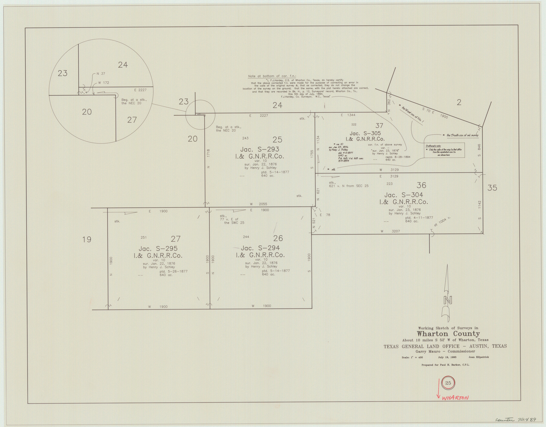
Wharton County Working Sketch 25
-
Map/Doc
72489
-
Collection
General Map Collection
-
Object Dates
7/19/1993 (Creation Date)
-
People and Organizations
Joan Kilpatrick (Draftsman)
-
Counties
Wharton
-
Subjects
Surveying Working Sketch
-
Height x Width
20.0 x 25.5 inches
50.8 x 64.8 cm
-
Scale
1" = 400 varas
Part of: General Map Collection
Jackson County Rolled Sketch 3C

Print $59.00
- Digital $50.00
Jackson County Rolled Sketch 3C
1913
Size 23.7 x 21.8 inches
Map/Doc 6339
Kimble County Sketch File 6

Print $4.00
- Digital $50.00
Kimble County Sketch File 6
Size 6.4 x 8.0 inches
Map/Doc 28918
Childress County Rolled Sketch 18

Print $20.00
- Digital $50.00
Childress County Rolled Sketch 18
1913
Size 17.6 x 39.0 inches
Map/Doc 5451
Flight Mission No. BRA-16M, Frame 49, Jefferson County

Print $20.00
- Digital $50.00
Flight Mission No. BRA-16M, Frame 49, Jefferson County
1953
Size 18.4 x 22.5 inches
Map/Doc 85666
Northern Part of Laguna Madre

Print $20.00
- Digital $50.00
Northern Part of Laguna Madre
1972
Size 44.2 x 35.0 inches
Map/Doc 73529
Flight Mission No. DAG-19K, Frame 65, Matagorda County

Print $20.00
- Digital $50.00
Flight Mission No. DAG-19K, Frame 65, Matagorda County
1952
Size 18.5 x 22.3 inches
Map/Doc 86392
Kendall County Sketch File 22

Print $20.00
- Digital $50.00
Kendall County Sketch File 22
1926
Size 17.0 x 25.8 inches
Map/Doc 11910
Polk County Rolled Sketch 20

Print $20.00
- Digital $50.00
Polk County Rolled Sketch 20
Size 30.8 x 22.9 inches
Map/Doc 7312
Current Miscellaneous File 6

Print $4.00
- Digital $50.00
Current Miscellaneous File 6
Size 11.3 x 8.8 inches
Map/Doc 73731
Flight Mission No. DCL-6C, Frame 127, Kenedy County

Print $20.00
- Digital $50.00
Flight Mission No. DCL-6C, Frame 127, Kenedy County
1943
Size 18.5 x 22.3 inches
Map/Doc 85957
Crockett County Working Sketch 7

Print $20.00
- Digital $50.00
Crockett County Working Sketch 7
1891
Size 18.4 x 21.7 inches
Map/Doc 68340
Flight Mission No. DQN-5K, Frame 61, Calhoun County

Print $20.00
- Digital $50.00
Flight Mission No. DQN-5K, Frame 61, Calhoun County
1953
Size 18.7 x 22.3 inches
Map/Doc 84404
You may also like
Palo Pinto County

Print $20.00
- Digital $50.00
Palo Pinto County
1898
Size 44.3 x 37.3 inches
Map/Doc 78400
Liberty County Sketch File 58

Print $2.00
- Digital $50.00
Liberty County Sketch File 58
Size 8.9 x 7.7 inches
Map/Doc 30060
Kendall County

Print $20.00
- Digital $50.00
Kendall County
1946
Size 42.5 x 36.8 inches
Map/Doc 95553
Dallas County Working Sketch 18

Print $20.00
- Digital $50.00
Dallas County Working Sketch 18
1989
Size 39.9 x 37.4 inches
Map/Doc 68584
Hutchinson County Working Sketch 11

Print $20.00
- Digital $50.00
Hutchinson County Working Sketch 11
1924
Size 20.4 x 29.4 inches
Map/Doc 66369

Kenedy County Rolled Sketch 17

Print $40.00
- Digital $50.00
Kenedy County Rolled Sketch 17
1958
Size 96.6 x 28.5 inches
Map/Doc 10726
[Part of Block GG and river sections 69-79]
![90470, [Part of Block GG and river sections 69-79], Twichell Survey Records](https://historictexasmaps.com/wmedia_w700/maps/90470-1.tif.jpg)
Print $20.00
- Digital $50.00
[Part of Block GG and river sections 69-79]
Size 43.2 x 31.2 inches
Map/Doc 90470
Brown County Rolled Sketch 2B

Print $20.00
- Digital $50.00
Brown County Rolled Sketch 2B
1984
Size 24.3 x 18.6 inches
Map/Doc 5351
The United States of Mexico

Print $20.00
- Digital $50.00
The United States of Mexico
1832
Size 15.4 x 12.8 inches
Map/Doc 93952
Enoch's Land Situated in Bailey and Cochran Counties, Texas

Print $20.00
- Digital $50.00
Enoch's Land Situated in Bailey and Cochran Counties, Texas
1925
Size 29.1 x 35.7 inches
Map/Doc 92515
Pecos County Working Sketch 27
Print $40.00
- Digital $50.00
Pecos County Working Sketch 27
1929
Size 36.9 x 50.8 inches
Map/Doc 71498