Tom Green County Sketch File 74
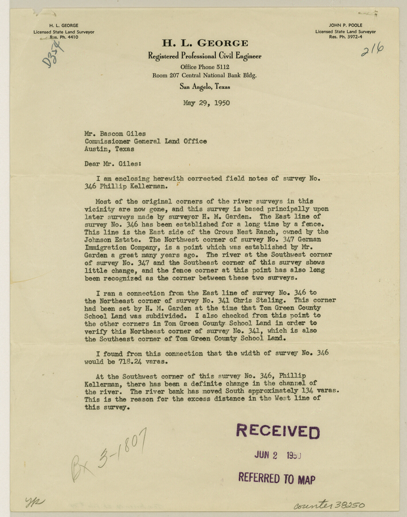
[Letter and explanation regarding corrected field notes of survey 346, Phillip Kellerman]
-
Map/Doc
38250
-
Collection
General Map Collection
-
Object Dates
5/29/1950 (Creation Date)
6/9/1950 (File Date)
-
People and Organizations
H.L. George (Surveyor/Engineer)
-
Counties
Tom Green
-
Subjects
Surveying Sketch File
-
Height x Width
11.3 x 8.9 inches
28.7 x 22.6 cm
-
Medium
mylar, print
-
Features
Crow's Nest Ranch
Part of: General Map Collection
Flight Mission No. BRE-2P, Frame 97, Nueces County

Print $20.00
- Digital $50.00
Flight Mission No. BRE-2P, Frame 97, Nueces County
1956
Size 18.5 x 22.3 inches
Map/Doc 86782
Nueces County Sketch File 58

Print $162.00
- Digital $50.00
Nueces County Sketch File 58
1981
Size 11.2 x 8.5 inches
Map/Doc 32920
Carson County Rolled Sketch 1

Print $20.00
- Digital $50.00
Carson County Rolled Sketch 1
Size 31.2 x 33.4 inches
Map/Doc 8580
Flight Mission No. DAG-23K, Frame 60, Matagorda County

Print $20.00
- Digital $50.00
Flight Mission No. DAG-23K, Frame 60, Matagorda County
1953
Size 15.8 x 15.8 inches
Map/Doc 86487
Wise County Working Sketch 26

Print $20.00
- Digital $50.00
Wise County Working Sketch 26
1987
Size 25.8 x 33.7 inches
Map/Doc 72640
Harris County State Real Property Sketch 3

Print $42.00
- Digital $50.00
Harris County State Real Property Sketch 3
2004
Size 24.9 x 36.9 inches
Map/Doc 81952
Denton County Rolled Sketch 6

Print $20.00
- Digital $50.00
Denton County Rolled Sketch 6
1983
Size 25.4 x 37.2 inches
Map/Doc 5702
Ector County Working Sketch 5

Print $20.00
- Digital $50.00
Ector County Working Sketch 5
1941
Size 44.7 x 27.1 inches
Map/Doc 68848
Tom Green County

Print $40.00
- Digital $50.00
Tom Green County
Size 43.6 x 111.2 inches
Map/Doc 82058
Val Verde County Working Sketch 91

Print $20.00
- Digital $50.00
Val Verde County Working Sketch 91
1976
Size 46.5 x 42.8 inches
Map/Doc 72226
Harrison County Rolled Sketch 15

Print $20.00
- Digital $50.00
Harrison County Rolled Sketch 15
2008
Size 20.5 x 21.0 inches
Map/Doc 89045
Fractional Township No. 10 South Range No. 27 East of the Indian Meridian, Indian Territory

Print $20.00
- Digital $50.00
Fractional Township No. 10 South Range No. 27 East of the Indian Meridian, Indian Territory
1897
Size 19.2 x 24.3 inches
Map/Doc 75246
You may also like
Parker County Sketch File C

Print $4.00
- Digital $50.00
Parker County Sketch File C
1857
Size 6.1 x 7.8 inches
Map/Doc 33512
Duval County Working Sketch 38

Print $20.00
- Digital $50.00
Duval County Working Sketch 38
1960
Size 18.3 x 22.8 inches
Map/Doc 68762
Tarrant County Sketch File 6

Print $4.00
- Digital $50.00
Tarrant County Sketch File 6
1859
Size 6.8 x 8.3 inches
Map/Doc 37682
Real County Working Sketch 34

Print $20.00
- Digital $50.00
Real County Working Sketch 34
1948
Size 25.6 x 29.0 inches
Map/Doc 71926
Denton County Working Sketch 9

Print $20.00
- Digital $50.00
Denton County Working Sketch 9
1959
Size 33.7 x 37.6 inches
Map/Doc 68614
Comal County State Real Property Sketch 1

Print $134.00
- Digital $50.00
Comal County State Real Property Sketch 1
2006
Size 23.8 x 35.4 inches
Map/Doc 88635
Portion of Scurry County

Print $20.00
- Digital $50.00
Portion of Scurry County
1882
Size 35.1 x 25.3 inches
Map/Doc 92923
Carte Geo-Hydrographique du Golfe du Mexique et de ses Isles construite d'après les mémoires les plus recens, et assujeties, pour l'emplacement de ces principales positions aux latitudes et longitudes

Print $20.00
- Digital $50.00
Carte Geo-Hydrographique du Golfe du Mexique et de ses Isles construite d'après les mémoires les plus recens, et assujeties, pour l'emplacement de ces principales positions aux latitudes et longitudes
1771
Size 15.0 x 20.5 inches
Map/Doc 94108
Hood County Sketch File 6

Print $4.00
- Digital $50.00
Hood County Sketch File 6
Size 7.2 x 6.1 inches
Map/Doc 26579
The Judicial District/County of Ward. Abolished, Spring 1842

Print $20.00
The Judicial District/County of Ward. Abolished, Spring 1842
2020
Size 18.7 x 21.7 inches
Map/Doc 96355
Tom Green County Rolled Sketch 21

Print $20.00
- Digital $50.00
Tom Green County Rolled Sketch 21
Size 20.2 x 12.9 inches
Map/Doc 8004
Lipscomb County Rolled Sketch 5

Print $40.00
- Digital $50.00
Lipscomb County Rolled Sketch 5
Size 61.8 x 8.1 inches
Map/Doc 10640