Denton County Rolled Sketch 6
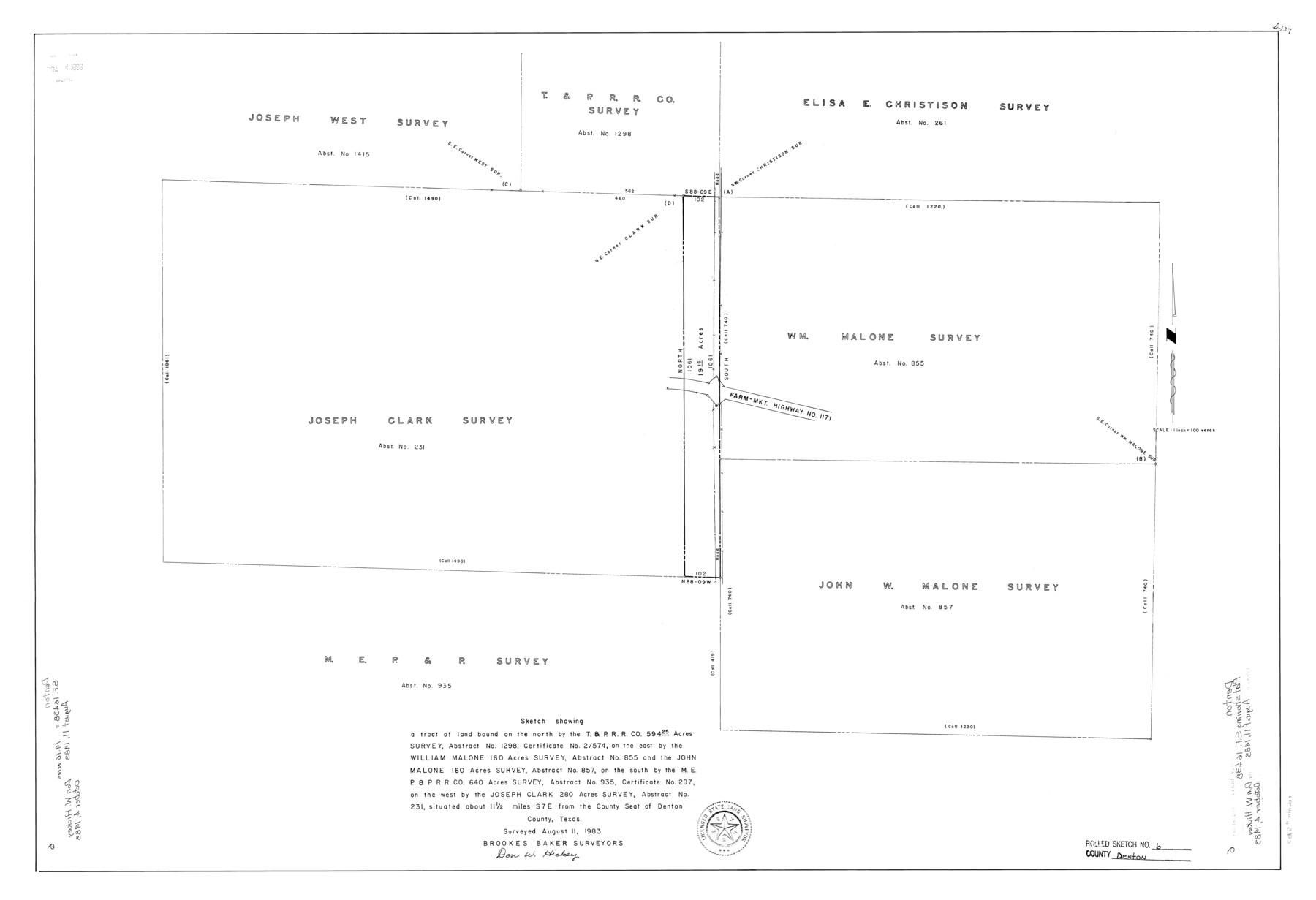
Sketch showing a tract of land [bound on the north by A-1298, on the east by A-855 and A-857, on the south by A-935 and on the west by A-231]
-
Map/Doc
5702
-
Collection
General Map Collection
-
Object Dates
1983/8/11 (Creation Date)
1983/10/4 (File Date)
-
People and Organizations
Don W. Hickey (Surveyor/Engineer)
-
Counties
Denton
-
Subjects
Surveying Rolled Sketch
-
Height x Width
25.4 x 37.2 inches
64.5 x 94.5 cm
-
Scale
1" = 100 varas
Part of: General Map Collection
Stephens County Sketch File 10a

Print $8.00
- Digital $50.00
Stephens County Sketch File 10a
1884
Size 12.7 x 8.5 inches
Map/Doc 37044
Presidio County Working Sketch 52

Print $20.00
- Digital $50.00
Presidio County Working Sketch 52
1954
Size 46.5 x 27.6 inches
Map/Doc 71729
Bee County Sketch File 2a

Print $6.00
- Digital $50.00
Bee County Sketch File 2a
1847
Size 7.9 x 13.0 inches
Map/Doc 14356
Sutton County Rolled Sketch 57

Print $40.00
- Digital $50.00
Sutton County Rolled Sketch 57
1958
Size 40.1 x 51.1 inches
Map/Doc 10662
Kimble County

Print $40.00
- Digital $50.00
Kimble County
1890
Size 37.4 x 58.6 inches
Map/Doc 16866
Map of the country adjacent to the left bank of the Rio Grande below Matamoros

Print $20.00
- Digital $50.00
Map of the country adjacent to the left bank of the Rio Grande below Matamoros
1847
Size 18.3 x 28.2 inches
Map/Doc 72871
Wheeler County Working Sketch 5

Print $40.00
- Digital $50.00
Wheeler County Working Sketch 5
1972
Size 55.3 x 45.9 inches
Map/Doc 72494
Calhoun County Rolled Sketch 30

Print $20.00
- Digital $50.00
Calhoun County Rolled Sketch 30
1974
Size 18.6 x 27.3 inches
Map/Doc 5487
El Paso County Sketch File 17

Print $20.00
- Digital $50.00
El Paso County Sketch File 17
1885
Size 20.1 x 30.9 inches
Map/Doc 11453
Flight Mission No. CGI-3N, Frame 143, Cameron County

Print $20.00
- Digital $50.00
Flight Mission No. CGI-3N, Frame 143, Cameron County
1954
Size 18.5 x 22.1 inches
Map/Doc 84616

Jefferson County Working Sketch 28

Print $20.00
- Digital $50.00
Jefferson County Working Sketch 28
1977
Size 46.2 x 42.9 inches
Map/Doc 66571
You may also like
Chambers County NRC Article 33.136 Sketch 5

Print $22.00
- Digital $50.00
Chambers County NRC Article 33.136 Sketch 5
2003
Size 24.2 x 18.3 inches
Map/Doc 78608
The Republic County of Bastrop. January 25, 1840

Print $20.00
The Republic County of Bastrop. January 25, 1840
2020
Size 14.7 x 21.6 inches
Map/Doc 96091
General Highway Map, Crane County, Texas

Print $20.00
General Highway Map, Crane County, Texas
1940
Size 25.2 x 18.3 inches
Map/Doc 79061
A Map of That Part of Dallas County, lying in Nacogdoches Land District

Print $20.00
- Digital $50.00
A Map of That Part of Dallas County, lying in Nacogdoches Land District
1854
Size 29.9 x 22.6 inches
Map/Doc 4525
Abandoned and Canceled Surveys - Volume 2 of 3, Counties E-K

Abandoned and Canceled Surveys - Volume 2 of 3, Counties E-K
Map/Doc 83249
Rains County Sketch File 1

Print $6.00
- Digital $50.00
Rains County Sketch File 1
Size 5.9 x 9.1 inches
Map/Doc 34942
Schleicher County Sketch File 46

Print $4.00
- Digital $50.00
Schleicher County Sketch File 46
1958
Size 3.7 x 8.8 inches
Map/Doc 36554
Presidio County Rolled Sketch 48

Print $20.00
- Digital $50.00
Presidio County Rolled Sketch 48
1908
Size 29.9 x 35.1 inches
Map/Doc 9775
Schleicher County Rolled Sketch 12

Print $20.00
- Digital $50.00
Schleicher County Rolled Sketch 12
1952
Size 28.8 x 29.0 inches
Map/Doc 7755
The Republic County of Harrison. December 31, 1844

Print $20.00
The Republic County of Harrison. December 31, 1844
2020
Size 18.6 x 21.7 inches
Map/Doc 96176
Comal County Rolled Sketch 2

Print $20.00
- Digital $50.00
Comal County Rolled Sketch 2
1974
Size 21.8 x 13.3 inches
Map/Doc 5537
Map of Kerr County

Print $20.00
- Digital $50.00
Map of Kerr County
1878
Size 20.5 x 25.7 inches
Map/Doc 3762