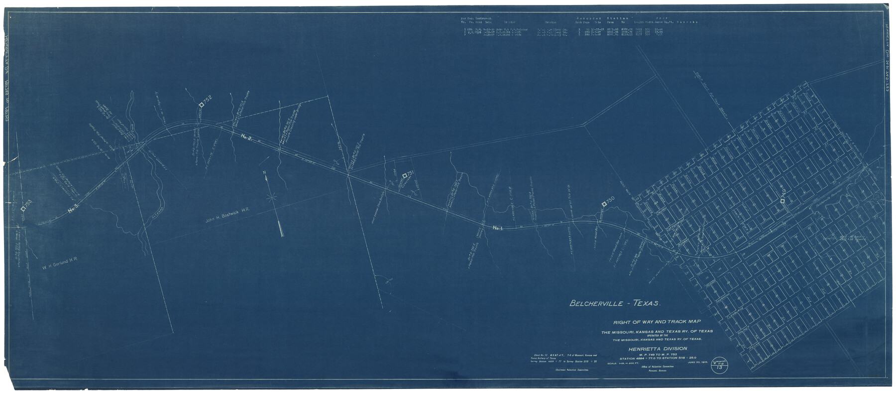
Right of Way and Track Map, The Missouri, Kansas and Texas Ry. of Texas operated by the Missouri, Kansas and Texas Ry. of Texas, Henrietta Division
M.P. 749 to M.P. 753, Station 4884+77.0 to Station 5118+25.0
Z-2-20
-
Map/Doc
64072
-
Collection
General Map Collection
-
Object Dates
6/30/1918 (Creation Date)
-
People and Organizations
Office of Valuation Committee (Publisher)
-
Counties
Montague
-
Subjects
Railroads
-
Height x Width
25.1 x 56.7 inches
63.8 x 144.0 cm
-
Medium
blueprint/diazo
-
Scale
1" = 400 feet
-
Comments
See 64065-64071, 64073, and 64074 for other segments of the map. See 64064 (PDF) for the documents/letter that accompanied the map.
-
Features
MK&T
Belknap Creek
Cemetery
Belcherville
Belcherville Reservoir
Part of: General Map Collection
Jim Hogg County Working Sketch 9

Print $20.00
- Digital $50.00
Jim Hogg County Working Sketch 9
1973
Size 14.3 x 11.2 inches
Map/Doc 66595
Andrews County Rolled Sketch 21

Print $20.00
- Digital $50.00
Andrews County Rolled Sketch 21
Size 18.2 x 26.3 inches
Map/Doc 77169
Brazos County Sketch File 1

Print $4.00
- Digital $50.00
Brazos County Sketch File 1
1858
Size 10.4 x 7.6 inches
Map/Doc 15550
Concho County Sketch File 10

Print $20.00
- Digital $50.00
Concho County Sketch File 10
1887
Size 23.1 x 33.8 inches
Map/Doc 11150
Flight Mission No. BRE-2P, Frame 47, Nueces County

Print $20.00
- Digital $50.00
Flight Mission No. BRE-2P, Frame 47, Nueces County
1956
Size 18.6 x 22.6 inches
Map/Doc 86749
Kinney County Rolled Sketch 8

Print $20.00
- Digital $50.00
Kinney County Rolled Sketch 8
Size 28.0 x 43.9 inches
Map/Doc 6537
Flight Mission No. DCL-7C, Frame 70, Kenedy County

Print $20.00
- Digital $50.00
Flight Mission No. DCL-7C, Frame 70, Kenedy County
1943
Size 15.4 x 15.3 inches
Map/Doc 86056

Culberson County Working Sketch 67

Print $40.00
- Digital $50.00
Culberson County Working Sketch 67
1975
Size 48.9 x 33.2 inches
Map/Doc 68521
Gregg County Working Sketch 12

Print $20.00
- Digital $50.00
Gregg County Working Sketch 12
1940
Size 11.0 x 18.9 inches
Map/Doc 63279
Castro County Working Sketch 2

Print $20.00
- Digital $50.00
Castro County Working Sketch 2
Size 30.4 x 26.2 inches
Map/Doc 67897
Flight Mission No. CLL-3N, Frame 42, Willacy County

Print $20.00
- Digital $50.00
Flight Mission No. CLL-3N, Frame 42, Willacy County
1954
Size 18.5 x 22.1 inches
Map/Doc 87100
You may also like
Dimmit County Working Sketch 49

Print $40.00
- Digital $50.00
Dimmit County Working Sketch 49
1980
Size 78.8 x 44.7 inches
Map/Doc 68710
Nueces County Rolled Sketch 30

Print $40.00
- Digital $50.00
Nueces County Rolled Sketch 30
1952
Size 60.3 x 38.9 inches
Map/Doc 9598
Chart of the Harbour of San [Luis]
![72762, Chart of the Harbour of San [Luis], General Map Collection](https://historictexasmaps.com/wmedia_w700/maps/72762.tif.jpg)
Print $20.00
- Digital $50.00
Chart of the Harbour of San [Luis]
1846
Size 27.2 x 18.2 inches
Map/Doc 72762
Titus County Sketch File 13

Print $6.00
- Digital $50.00
Titus County Sketch File 13
1929
Size 9.0 x 8.8 inches
Map/Doc 38154

Chambers County Sketch File 41

Print $32.00
- Digital $50.00
Chambers County Sketch File 41
Size 14.7 x 9.1 inches
Map/Doc 17694
Lampasas County Boundary File 15

Print $14.00
- Digital $50.00
Lampasas County Boundary File 15
Size 8.8 x 6.6 inches
Map/Doc 56203
Sterling County Sketch File 2

Print $6.00
- Digital $50.00
Sterling County Sketch File 2
Size 10.7 x 15.6 inches
Map/Doc 37113
Uvalde County Sketch File 30

Print $12.00
- Digital $50.00
Uvalde County Sketch File 30
1990
Size 4.4 x 9.9 inches
Map/Doc 39032
General Highway Map, Collingsworth County, Texas

Print $20.00
General Highway Map, Collingsworth County, Texas
1940
Size 18.3 x 25.2 inches
Map/Doc 79053

Nueces County Rolled Sketch 43B

Print $20.00
- Digital $50.00
Nueces County Rolled Sketch 43B
Size 28.0 x 36.5 inches
Map/Doc 6885