Pecos County Sketch File 29a
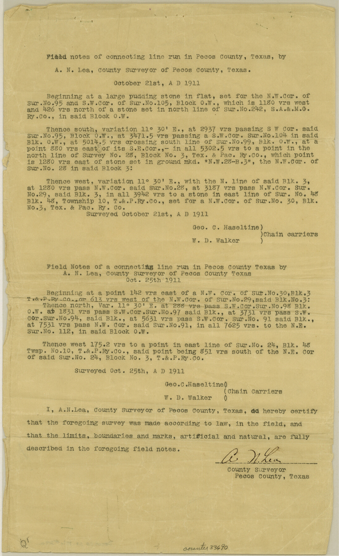
[Field notes of connecting line run in Pecos County]
-
Map/Doc
33690
-
Collection
General Map Collection
-
Object Dates
12/15/1911 (File Date)
10/21/1911 (Creation Date)
10/21/1911 (Survey Date)
10/25/1911 (Survey Date)
10/31/1911 (Survey Date)
11/9/1911 (Survey Date)
-
People and Organizations
A.N. Lea (Surveyor/Engineer)
George C. Haseltine (Chainman/Field Personnel)
W.D. Walker (Chainman/Field Personnel)
George Teague (Chainman/Field Personnel)
-
Counties
Pecos
-
Subjects
Surveying Sketch File
-
Height x Width
14.2 x 8.6 inches
36.1 x 21.8 cm
-
Medium
paper, print
Part of: General Map Collection
Frio County Working Sketch 28

Print $20.00
- Digital $50.00
Frio County Working Sketch 28
2006
Size 40.8 x 42.0 inches
Map/Doc 83605

Coleman County Sketch File 44

Print $17.00
- Digital $50.00
Coleman County Sketch File 44
Size 14.1 x 8.6 inches
Map/Doc 18783
Flight Mission No. DCL-7C, Frame 3, Kenedy County

Print $20.00
- Digital $50.00
Flight Mission No. DCL-7C, Frame 3, Kenedy County
1943
Size 18.5 x 22.3 inches
Map/Doc 85995
Scurry County Sketch File 6

Print $14.00
- Digital $50.00
Scurry County Sketch File 6
2002
Size 11.2 x 8.7 inches
Map/Doc 76370
Val Verde County Rolled Sketch 69

Print $40.00
- Digital $50.00
Val Verde County Rolled Sketch 69
1942
Size 72.5 x 20.0 inches
Map/Doc 9805
Right of Way and Track Map Texas & New Orleans R.R. Co. operated by the T. & N. O. R.R. Co. Dallas-Sabine Branch

Print $40.00
- Digital $50.00
Right of Way and Track Map Texas & New Orleans R.R. Co. operated by the T. & N. O. R.R. Co. Dallas-Sabine Branch
1918
Size 26.4 x 56.7 inches
Map/Doc 64157
San Patricio County Working Sketch 9

Print $40.00
- Digital $50.00
San Patricio County Working Sketch 9
1937
Size 52.8 x 44.0 inches
Map/Doc 63771
Schleicher County Rolled Sketch 7

Print $20.00
- Digital $50.00
Schleicher County Rolled Sketch 7
Size 32.5 x 37.9 inches
Map/Doc 9904
Map of the East Part of Tom Green County

Print $40.00
- Digital $50.00
Map of the East Part of Tom Green County
1894
Size 45.9 x 49.4 inches
Map/Doc 63071
Kinney County Working Sketch 51

Print $20.00
- Digital $50.00
Kinney County Working Sketch 51
1980
Size 34.6 x 47.2 inches
Map/Doc 70233
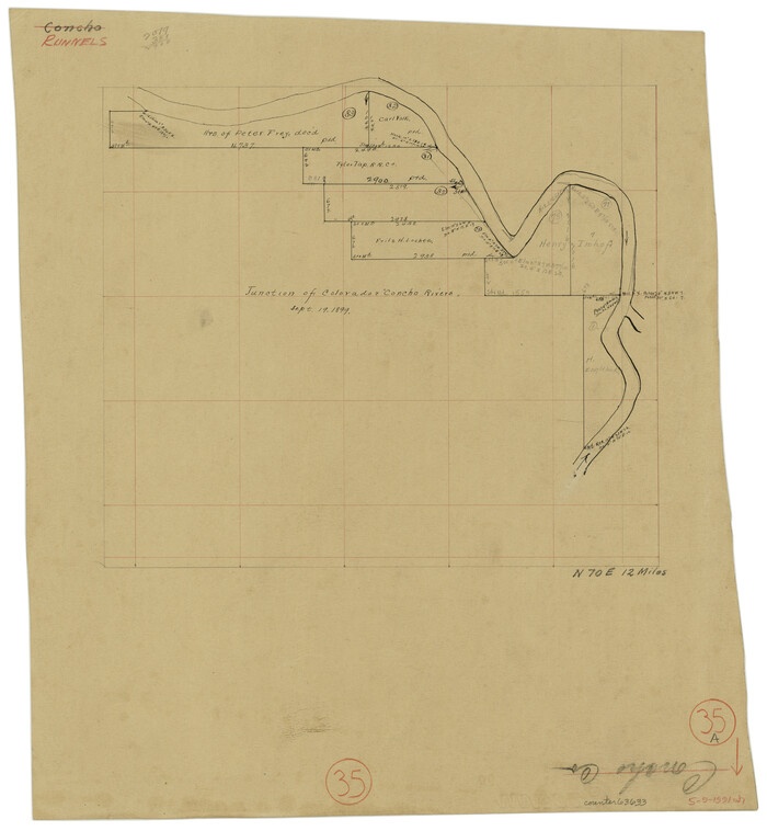
Runnels County Working Sketch 35a
Print $20.00
- Digital $50.00
Runnels County Working Sketch 35a
Size 14.9 x 14.2 inches
Map/Doc 63633
You may also like
[Leagues 70, 71, 72, 73, 74, 75, 704, 705, 718, 719, and 732]
![91098, [Leagues 70, 71, 72, 73, 74, 75, 704, 705, 718, 719, and 732], Twichell Survey Records](https://historictexasmaps.com/wmedia_w700/maps/91098-1.tif.jpg)
Print $2.00
- Digital $50.00
[Leagues 70, 71, 72, 73, 74, 75, 704, 705, 718, 719, and 732]
Size 6.0 x 11.1 inches
Map/Doc 91098
Briscoe County Rolled Sketch WL

Print $20.00
- Digital $50.00
Briscoe County Rolled Sketch WL
1936
Size 18.6 x 43.0 inches
Map/Doc 5335
Flight Mission No. DQO-3K, Frame 38, Galveston County

Print $20.00
- Digital $50.00
Flight Mission No. DQO-3K, Frame 38, Galveston County
1952
Size 18.7 x 22.3 inches
Map/Doc 85079
[Sketch highlighting Bob Reid and Fred Turner surveys]
![91693, [Sketch highlighting Bob Reid and Fred Turner surveys], Twichell Survey Records](https://historictexasmaps.com/wmedia_w700/maps/91693-1.tif.jpg)
Print $20.00
- Digital $50.00
[Sketch highlighting Bob Reid and Fred Turner surveys]
Size 12.5 x 17.8 inches
Map/Doc 91693
Edwards County Working Sketch 49

Print $20.00
- Digital $50.00
Edwards County Working Sketch 49
1950
Size 23.6 x 28.1 inches
Map/Doc 68925
[Blk. M, T. & P. Blocks 33-36, Townships 5N and 6N]
![90549, [Blk. M, T. & P. Blocks 33-36, Townships 5N and 6N], Twichell Survey Records](https://historictexasmaps.com/wmedia_w700/maps/90549-1.tif.jpg)
Print $20.00
- Digital $50.00
[Blk. M, T. & P. Blocks 33-36, Townships 5N and 6N]
Size 16.2 x 12.2 inches
Map/Doc 90549
Maverick County Rolled Sketch 25

Print $20.00
- Digital $50.00
Maverick County Rolled Sketch 25
1999
Size 24.6 x 24.7 inches
Map/Doc 82574
Flight Mission No. DCL-4C, Frame 4, Kenedy County

Print $20.00
- Digital $50.00
Flight Mission No. DCL-4C, Frame 4, Kenedy County
1943
Size 18.7 x 22.3 inches
Map/Doc 85805
Bailey County Working Sketch 2

Print $20.00
- Digital $50.00
Bailey County Working Sketch 2
1920
Size 17.8 x 16.2 inches
Map/Doc 67589
Controlled Mosaic by Jack Amman Photogrammetric Engineers, Inc - Sheet 37

Print $20.00
- Digital $50.00
Controlled Mosaic by Jack Amman Photogrammetric Engineers, Inc - Sheet 37
1954
Size 20.0 x 24.0 inches
Map/Doc 83490
Kleberg County Rolled Sketch 7

Print $20.00
- Digital $50.00
Kleberg County Rolled Sketch 7
1947
Size 28.5 x 41.4 inches
Map/Doc 6550
Flight Mission No. DQN-5K, Frame 79, Calhoun County

Print $20.00
- Digital $50.00
Flight Mission No. DQN-5K, Frame 79, Calhoun County
1953
Size 18.5 x 22.2 inches
Map/Doc 84412