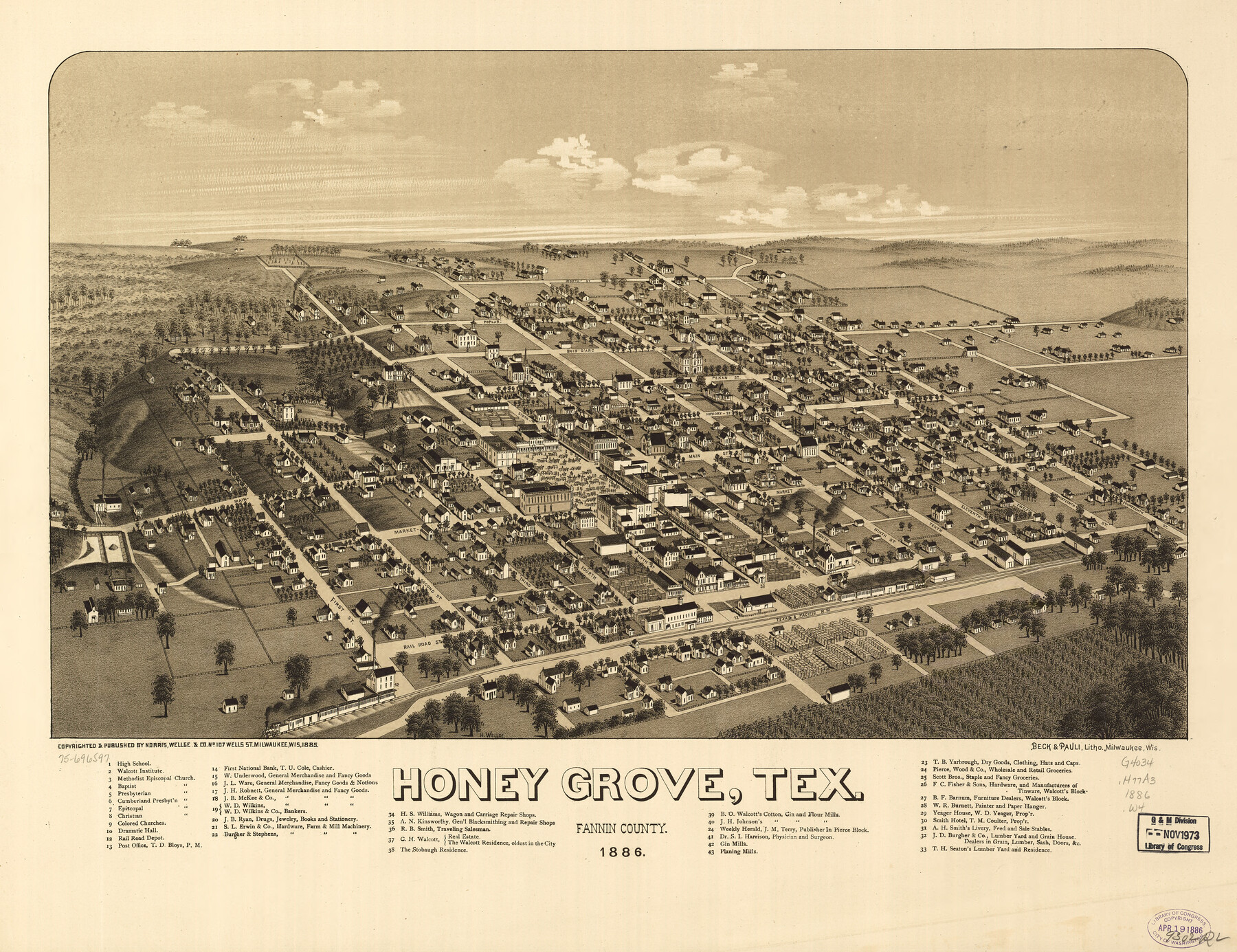
Honey Grove, Tex., Fannin County, 1886
-
Map/Doc
93479
-
Collection
Library of Congress
-
Object Dates
1886 (Creation Date)
-
People and Organizations
Norris, Wellge and Co. (Publisher)
Beck and Pauli, Litho. (Printer)
-
Counties
Fannin
-
Subjects
Bird's Eye View City Pictorial
-
Height x Width
18.4 x 23.9 inches
46.7 x 60.7 cm
-
Comments
Bird's Eye View map. For more information see here. Prints available from the GLO courtesy of Library of Congress, Geography and Map Division.
Part of: Library of Congress
New Map of Texas with the Contiguous American and Mexican States

Print $20.00
New Map of Texas with the Contiguous American and Mexican States
1835
Size 13.3 x 15.9 inches
Map/Doc 88894
General Chart of the Kingdom of New Spain betn. parallels of 16 & 38° N. from materials in Mexico at commencement of year of 1804

Print $20.00
General Chart of the Kingdom of New Spain betn. parallels of 16 & 38° N. from materials in Mexico at commencement of year of 1804
1804
Size 38.4 x 26.5 inches
Map/Doc 95310


A Map of Mexico, Louisiana and the Missouri Territory, including also the State of Mississippi, Alabama Territory, East & West Florida, Georgia, South Carolina & part of the Island of Cuba

Print $40.00
A Map of Mexico, Louisiana and the Missouri Territory, including also the State of Mississippi, Alabama Territory, East & West Florida, Georgia, South Carolina & part of the Island of Cuba
Size 66.9 x 64.2 inches
Map/Doc 95312
Map of Bexar County Showing Subdivisions of Original Surveys and Names of Present Owners

Print $20.00
Map of Bexar County Showing Subdivisions of Original Surveys and Names of Present Owners
1897
Size 46.2 x 41.3 inches
Map/Doc 88908
Map of the River Sabine from Logan's Ferry to 32nd Degree of North Latitude

Print $20.00
Map of the River Sabine from Logan's Ferry to 32nd Degree of North Latitude
1841
Size 21.4 x 27.8 inches
Map/Doc 88902
Croquis del terro, camino, bosques, barrancas, cerro y beredas de Cerro-gordo con las posiciones de las topas Mejicanas y Americanas con sus respectivos Generales Cuerpos y Baterias el dis 18 de Abril de 1847

Print $20.00
Croquis del terro, camino, bosques, barrancas, cerro y beredas de Cerro-gordo con las posiciones de las topas Mejicanas y Americanas con sus respectivos Generales Cuerpos y Baterias el dis 18 de Abril de 1847
1847
Size 20.1 x 26.0 inches
Map/Doc 97343
Map of the post of Fort Brown, Brownsville, Texas

Print $20.00
Map of the post of Fort Brown, Brownsville, Texas
1877
Size 24.0 x 33.9 inches
Map/Doc 93560
[Map showing T&P Lands in El Paso County]
![88936, [Map showing T&P Lands in El Paso County], Library of Congress](https://historictexasmaps.com/wmedia_w700/maps/88936.tif.jpg)
Print $20.00
[Map showing T&P Lands in El Paso County]
Size 22.6 x 17.5 inches
Map/Doc 88936
You may also like
'O Bar O' Ranch

Print $20.00
- Digital $50.00
'O Bar O' Ranch
1946
Size 21.1 x 36.2 inches
Map/Doc 92162
Morris County Rolled Sketch 2A

Print $20.00
- Digital $50.00
Morris County Rolled Sketch 2A
Size 24.3 x 18.7 inches
Map/Doc 10675
Fort Bend County Rolled Sketch 16

Print $20.00
- Digital $50.00
Fort Bend County Rolled Sketch 16
1890
Size 29.3 x 26.5 inches
Map/Doc 5900
Sutton County Sketch File 57

Print $24.00
- Digital $50.00
Sutton County Sketch File 57
1961
Size 11.2 x 8.8 inches
Map/Doc 37542
Map of Trinity County

Print $20.00
- Digital $50.00
Map of Trinity County
1862
Size 21.0 x 31.3 inches
Map/Doc 4096
Carta Etnografica

Print $20.00
- Digital $50.00
Carta Etnografica
1897
Size 26.2 x 34.1 inches
Map/Doc 96798
Dawson County Working Sketch 11

Print $20.00
- Digital $50.00
Dawson County Working Sketch 11
1946
Size 25.3 x 21.9 inches
Map/Doc 68555
Harris County Working Sketch 48

Print $20.00
- Digital $50.00
Harris County Working Sketch 48
1943
Size 26.8 x 16.0 inches
Map/Doc 65940
Hardin County Rolled Sketch 15

Print $20.00
- Digital $50.00
Hardin County Rolled Sketch 15
Size 26.6 x 29.0 inches
Map/Doc 6086
Clay County Working Sketch 7

Print $20.00
- Digital $50.00
Clay County Working Sketch 7
Size 17.5 x 14.7 inches
Map/Doc 68030
Map of the Melvin, Blum and Blum Lands situated in Bailey County, Texas

Print $40.00
- Digital $50.00
Map of the Melvin, Blum and Blum Lands situated in Bailey County, Texas
Size 40.1 x 80.7 inches
Map/Doc 93148
Texas Panhandle East Boundary Line

Print $20.00
- Digital $50.00
Texas Panhandle East Boundary Line
Size 37.5 x 8.7 inches
Map/Doc 65381