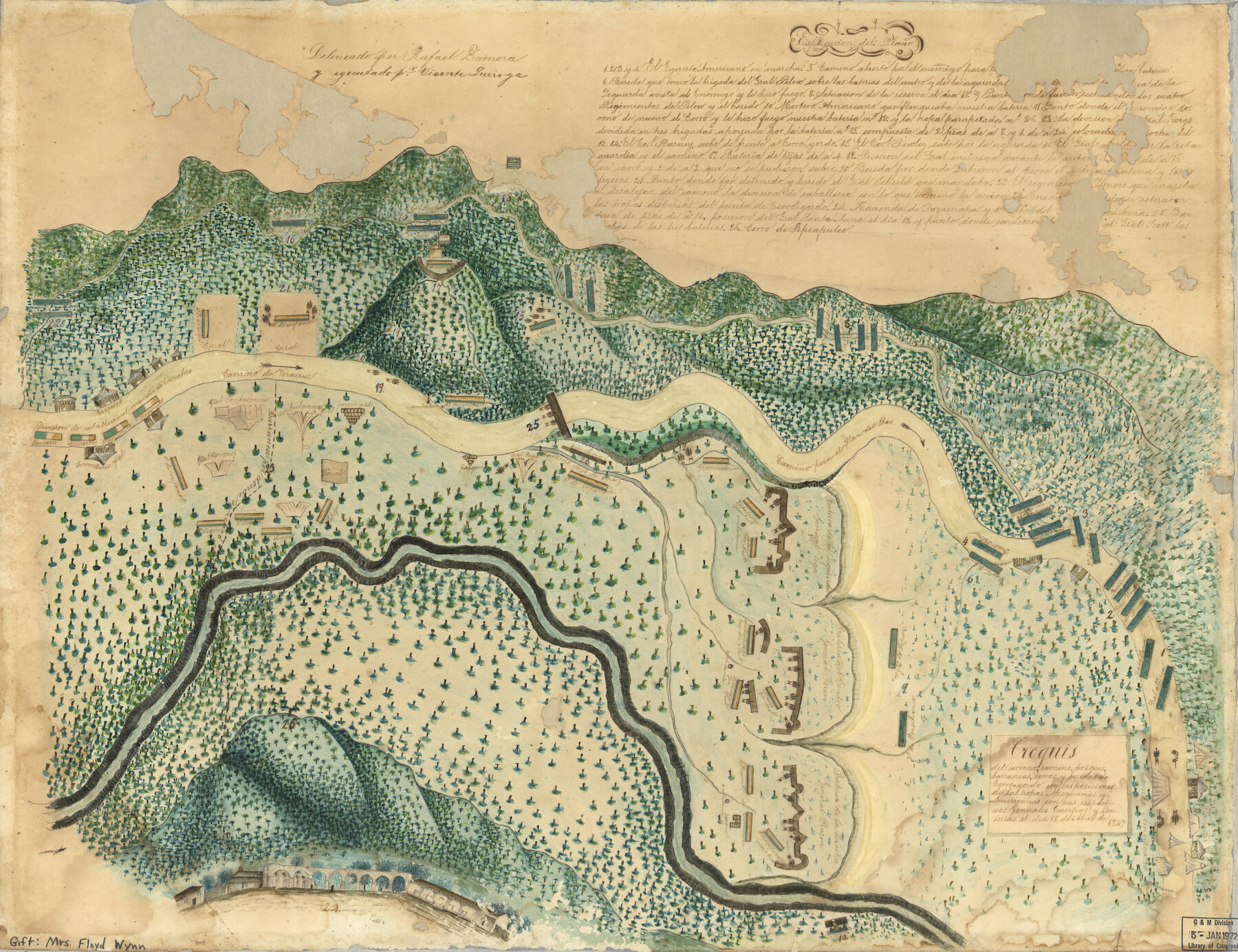
Croquis del terro, camino, bosques, barrancas, cerro y beredas de Cerro-gordo con las posiciones de las topas Mejicanas y Americanas con sus respectivos Generales Cuerpos y Baterias el dis 18 de Abril de 1847
-
Map/Doc
97343
-
Collection
Library of Congress
-
Object Dates
[1847] (Creation Date)
-
People and Organizations
Rafael Zamora (Draftsman)
Vicente Quiroga (Author)
-
Subjects
Mexico Military
-
Height x Width
20.1 x 26.0 inches
51.1 x 66.0 cm
Part of: Library of Congress
[Map showing T&P Lands in El Paso County]
![88936, [Map showing T&P Lands in El Paso County], Library of Congress](https://historictexasmaps.com/wmedia_w700/maps/88936.tif.jpg)
Print $20.00
[Map showing T&P Lands in El Paso County]
Size 22.6 x 17.5 inches
Map/Doc 88936
[Map showing T&P Lands in El Paso County]
![88935, [Map showing T&P Lands in El Paso County], Library of Congress](https://historictexasmaps.com/wmedia_w700/maps/88935.tif.jpg)
Print $20.00
[Map showing T&P Lands in El Paso County]
Size 22.2 x 17.4 inches
Map/Doc 88935
Sketch of Texas with the boundaries of Mexican States as shown on General Austin's map of Texas

Print $20.00
Sketch of Texas with the boundaries of Mexican States as shown on General Austin's map of Texas
1839
Size 20.9 x 16.1 inches
Map/Doc 93574
The railroad system of Texas on September 1st, 1883

Print $20.00
The railroad system of Texas on September 1st, 1883
1883
Size 20.1 x 26.8 inches
Map/Doc 93618

Perspective Map of the City of Laredo, Texas, the Gateway to and from Mexico

Print $20.00
Perspective Map of the City of Laredo, Texas, the Gateway to and from Mexico
1892
Size 24.0 x 36.7 inches
Map/Doc 93478

![88958, Jackson Co[unty], Library of Congress](https://historictexasmaps.com/wmedia_w700/maps/88958.tif.jpg)
Bird's Eye View of El Paso

Print $20.00
Bird's Eye View of El Paso
1885
Size 20.0 x 30.0 inches
Map/Doc 93621
Railroad map of the state of Texas / compiled and engraved expressly for the American railroad manual.

Print $20.00
Railroad map of the state of Texas / compiled and engraved expressly for the American railroad manual.
1873
Size 13.4 x 9.5 inches
Map/Doc 93599
Map of San Saba County : exhibiting the extent of public surveys, land grants, and other official information…

Print $20.00
Map of San Saba County : exhibiting the extent of public surveys, land grants, and other official information…
1876
Size 22.8 x 20.1 inches
Map/Doc 93593
Map of parts of Presidio, Brewster and Foley Counties

Print $20.00
Map of parts of Presidio, Brewster and Foley Counties
1891
Size 22.5 x 17.5 inches
Map/Doc 88987
You may also like

Index Map No. 1 - Rio Bravo del Norte section of boundary between the United States & Mexico; agreed upon by the Joint Commission under the Treaty of Guadalupe Hidalgo

Print $20.00
- Digital $50.00
Index Map No. 1 - Rio Bravo del Norte section of boundary between the United States & Mexico; agreed upon by the Joint Commission under the Treaty of Guadalupe Hidalgo
1852
Size 18.3 x 27.5 inches
Map/Doc 72862
[Blocks K3, K4, K7, K8, K14, M7, east part of Leagues]
![90593, [Blocks K3, K4, K7, K8, K14, M7, east part of Leagues], Twichell Survey Records](https://historictexasmaps.com/wmedia_w700/maps/90593-1.tif.jpg)
Print $20.00
- Digital $50.00
[Blocks K3, K4, K7, K8, K14, M7, east part of Leagues]
Size 32.6 x 32.4 inches
Map/Doc 90593
[County Line between DeWitt and Lavaca Counties]
![65355, [County Line between DeWitt and Lavaca Counties], General Map Collection](https://historictexasmaps.com/wmedia_w700/pdf_converted_jpg/qi_pdf_thumbnail_19782.jpg)
Print $226.00
- Digital $50.00
[County Line between DeWitt and Lavaca Counties]
1906
Size 17.4 x 34.4 inches
Map/Doc 65355
Brazos Santiago & Boca Chica entrances, Texas

Print $20.00
- Digital $50.00
Brazos Santiago & Boca Chica entrances, Texas
1867
Size 18.1 x 25.6 inches
Map/Doc 72927
Brewster County Rolled Sketch 122

Print $20.00
- Digital $50.00
Brewster County Rolled Sketch 122
1974
Size 31.9 x 24.6 inches
Map/Doc 5298
Young County Boundary File 98a

Print $32.00
- Digital $50.00
Young County Boundary File 98a
Size 10.2 x 8.0 inches
Map/Doc 60211
Flight Mission No. CUG-3P, Frame 159, Kleberg County

Print $20.00
- Digital $50.00
Flight Mission No. CUG-3P, Frame 159, Kleberg County
1956
Size 18.7 x 22.3 inches
Map/Doc 86279
King County Rolled Sketch 10

Print $20.00
- Digital $50.00
King County Rolled Sketch 10
Size 38.9 x 33.7 inches
Map/Doc 6532
From Citizens of Gonzales County for the Creation of a New Judicial County (Unnamed), December 14, 1841

Print $20.00
From Citizens of Gonzales County for the Creation of a New Judicial County (Unnamed), December 14, 1841
2020
Size 24.1 x 21.7 inches
Map/Doc 96410
Erath County Sketch File 8

Print $4.00
- Digital $50.00
Erath County Sketch File 8
Size 8.6 x 13.0 inches
Map/Doc 22269
[Sketch showing H. & T. C. R. R. Co. Blk. 48, S. P. R. R. Co. Blk. I, and E. T. R. R. Co. Blk. I]
![89647, [Sketch showing H. & T. C. R. R. Co. Blk. 48, S. P. R. R. Co. Blk. I, and E. T. R. R. Co. Blk. I], Twichell Survey Records](https://historictexasmaps.com/wmedia_w700/maps/89647-1.tif.jpg)
Print $40.00
- Digital $50.00
[Sketch showing H. & T. C. R. R. Co. Blk. 48, S. P. R. R. Co. Blk. I, and E. T. R. R. Co. Blk. I]
Size 51.4 x 9.2 inches
Map/Doc 89647