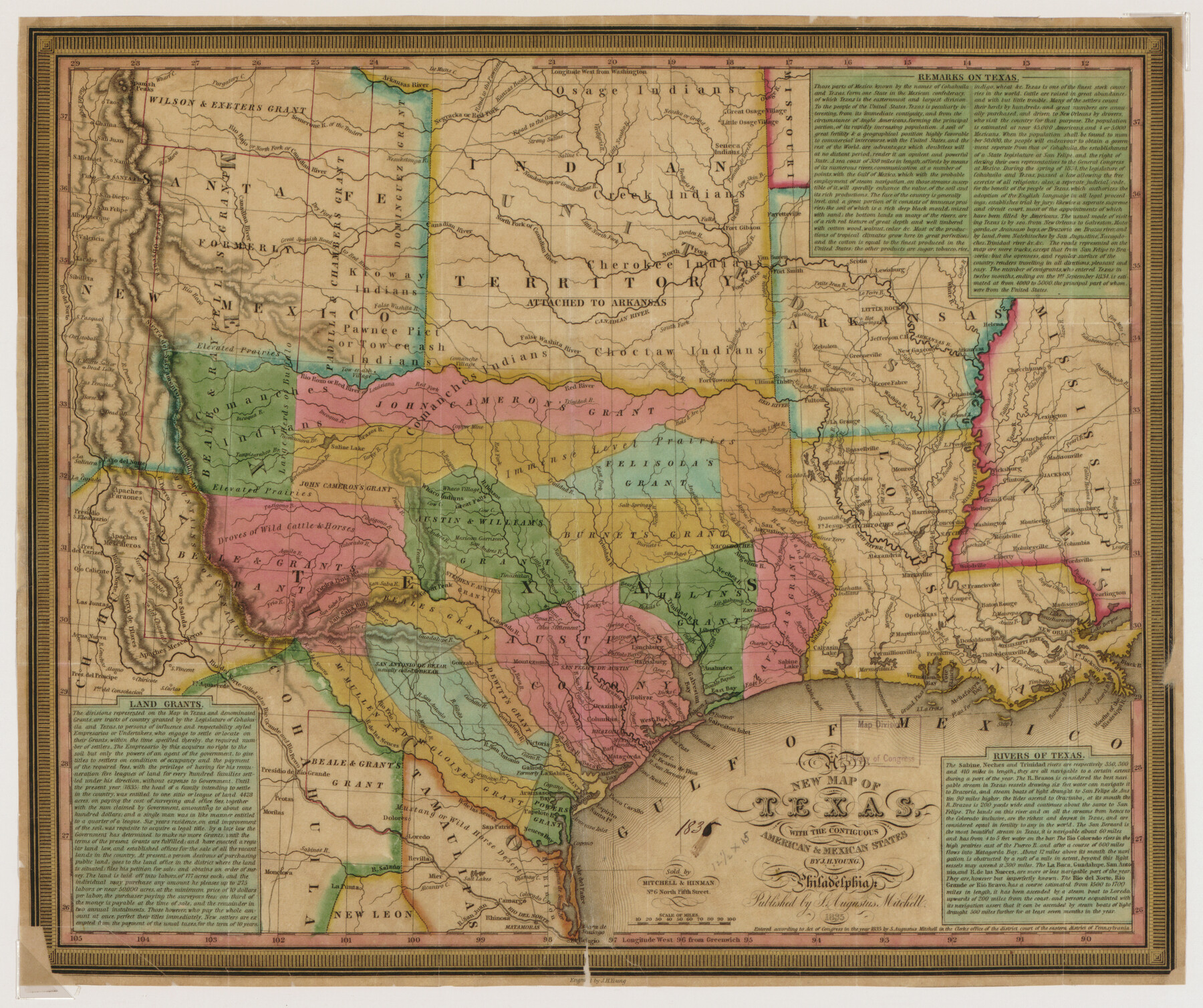
New Map of Texas with the Contiguous American and Mexican States
-
Map/Doc
88894
-
Collection
Library of Congress
-
Object Dates
1835 (Creation Date)
-
People and Organizations
S. Augustus Mitchell (Publisher)
J.H. Young (Author)
-
Subjects
Mexican Texas
-
Height x Width
13.3 x 15.9 inches
33.8 x 40.4 cm
-
Comments
For more information see here. Prints available from the GLO courtesy of Library of Congress, Geography and Map Division.
Part of: Library of Congress
Map of the Military Department of the Gulf

Print $20.00
Map of the Military Department of the Gulf
1864
Size 24.4 x 45.7 inches
Map/Doc 93568
Preliminary Chart of the Northwestern Part of the Gulf of Mexico - Unfinished Proof

Print $40.00
Preliminary Chart of the Northwestern Part of the Gulf of Mexico - Unfinished Proof
1861
Size 31.5 x 68.9 inches
Map/Doc 95308

Map of Caldwell County, Texas

Print $20.00
Map of Caldwell County, Texas
1880
Size 18.7 x 22.0 inches
Map/Doc 88915


Map of parts of Presidio, Brewster and Foley Counties

Print $20.00
Map of parts of Presidio, Brewster and Foley Counties
1891
Size 22.5 x 17.5 inches
Map/Doc 88987
Dallas, Texas. With the Projected River and Navigation Improvements. Viewed from Above the Sister City of Oak Cliff

Print $20.00
Dallas, Texas. With the Projected River and Navigation Improvements. Viewed from Above the Sister City of Oak Cliff
1892
Size 20.9 x 29.7 inches
Map/Doc 93474
[Map showing T&P Lands in El Paso County]
![88934, [Map showing T&P Lands in El Paso County], Library of Congress](https://historictexasmaps.com/wmedia_w700/maps/88934.tif.jpg)
Print $20.00
[Map showing T&P Lands in El Paso County]
Size 17.3 x 22.2 inches
Map/Doc 88934
Corpus Christi and Rio Grande Railway Company, [map showing the proposed railroad between Laredo and Corpus Christi and its connections with Mexico]
![93580, Corpus Christi and Rio Grande Railway Company, [map showing the proposed railroad between Laredo and Corpus Christi and its connections with Mexico], Library of Congress](https://historictexasmaps.com/wmedia_w700/maps/93580.tif.jpg)
Print $20.00
Corpus Christi and Rio Grande Railway Company, [map showing the proposed railroad between Laredo and Corpus Christi and its connections with Mexico]
1874
Size 14.6 x 24.0 inches
Map/Doc 93580
Map of Jones County, Texas

Print $20.00
Map of Jones County, Texas
1879
Size 24.7 x 18.8 inches
Map/Doc 88960

You may also like
Henderson County Working Sketch 25

Print $20.00
- Digital $50.00
Henderson County Working Sketch 25
1954
Size 42.0 x 31.2 inches
Map/Doc 66158
San Augustine County Sketch File 13

Print $4.00
San Augustine County Sketch File 13
1875
Size 11.4 x 7.6 inches
Map/Doc 35658
Galveston/Galveston Island, Texas

Galveston/Galveston Island, Texas
Size 18.4 x 24.3 inches
Map/Doc 94346
Sketch showing county lines of Lynn, Garza, Borden, Scurry

Print $40.00
- Digital $50.00
Sketch showing county lines of Lynn, Garza, Borden, Scurry
1961
Size 23.9 x 79.9 inches
Map/Doc 1719

Coast Chart No. 210 - Aransas Pass and Corpus Christi Bay with the coast to latitude 27° 12', Texas

Print $20.00
- Digital $50.00
Coast Chart No. 210 - Aransas Pass and Corpus Christi Bay with the coast to latitude 27° 12', Texas
1887
Size 23.4 x 29.4 inches
Map/Doc 73443
Map of Brazoria

Print $20.00
- Digital $50.00
Map of Brazoria
1860
Size 19.8 x 26.7 inches
Map/Doc 856
Travis County Appraisal District Plat Map 2_3216

Print $20.00
- Digital $50.00
Travis County Appraisal District Plat Map 2_3216
Size 21.5 x 26.4 inches
Map/Doc 94223

Irion County Boundary File 4

Print $23.00
- Digital $50.00
Irion County Boundary File 4
Size 11.2 x 8.8 inches
Map/Doc 55350
Jeff Davis County Working Sketch 11

Print $20.00
- Digital $50.00
Jeff Davis County Working Sketch 11
1947
Size 23.3 x 43.1 inches
Map/Doc 66506
The Republic County of Jasper. Spring 1842

Print $20.00
The Republic County of Jasper. Spring 1842
2020
Size 19.5 x 21.7 inches
Map/Doc 96195