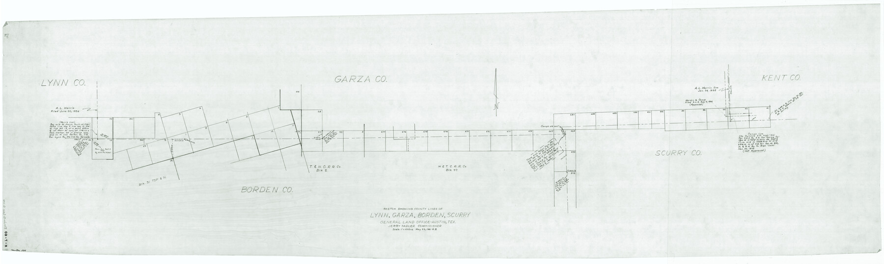
Sketch showing county lines of Lynn, Garza, Borden, Scurry
Lynn County Miscellaneous Sketch
K-7-60
-
Map/Doc
1719
-
Collection
General Map Collection
-
Object Dates
1961/5/23 (Creation Date)
-
People and Organizations
General Land Office (Publisher)
R.B. (Draftsman)
-
Counties
Lynn Garza Borden Scurry
-
Height x Width
23.9 x 79.9 inches
60.7 x 203.0 cm
Part of: General Map Collection
Zapata County Rolled Sketch 15

Print $20.00
- Digital $50.00
Zapata County Rolled Sketch 15
1925
Size 14.6 x 16.4 inches
Map/Doc 8313
Travis County Working Sketch 57

Print $20.00
- Digital $50.00
Travis County Working Sketch 57
1989
Size 42.8 x 44.0 inches
Map/Doc 69441
Jefferson County Sketch File 40

Print $16.00
- Digital $50.00
Jefferson County Sketch File 40
1947
Size 12.3 x 7.9 inches
Map/Doc 28228
Baylor County

Print $20.00
- Digital $50.00
Baylor County
1917
Size 47.3 x 40.7 inches
Map/Doc 66712
Castro County Sketch File 9

Print $4.00
- Digital $50.00
Castro County Sketch File 9
1908
Size 11.2 x 8.6 inches
Map/Doc 17499
Castro County Sketch File 4k

Print $4.00
- Digital $50.00
Castro County Sketch File 4k
Size 13.6 x 8.6 inches
Map/Doc 17485
[Sketch for Mineral Application 16777]
![65653, [Sketch for Mineral Application 16777], General Map Collection](https://historictexasmaps.com/wmedia_w700/maps/65653-1.tif.jpg)
Print $40.00
- Digital $50.00
[Sketch for Mineral Application 16777]
Size 19.5 x 79.9 inches
Map/Doc 65653
Denton County Sketch File C

Print $10.00
- Digital $50.00
Denton County Sketch File C
1882
Size 10.9 x 8.3 inches
Map/Doc 20682
Map of King County

Print $20.00
- Digital $50.00
Map of King County
1903
Size 45.4 x 42.9 inches
Map/Doc 66892
Tyler County Working Sketch 16

Print $20.00
- Digital $50.00
Tyler County Working Sketch 16
1960
Size 46.0 x 41.8 inches
Map/Doc 69486
Reagan County Rolled Sketch 29

Print $20.00
- Digital $50.00
Reagan County Rolled Sketch 29
1954
Size 35.6 x 35.4 inches
Map/Doc 9824
Nueces County Sketch File 69

Print $6.00
- Digital $50.00
Nueces County Sketch File 69
Size 11.1 x 8.7 inches
Map/Doc 33004
You may also like
[Plat map showing mostly Overton Addition]
![92825, [Plat map showing mostly Overton Addition], Twichell Survey Records](https://historictexasmaps.com/wmedia_w700/maps/92825-1.tif.jpg)
Print $20.00
- Digital $50.00
[Plat map showing mostly Overton Addition]
Size 31.7 x 31.4 inches
Map/Doc 92825
Wise County Working Sketch 13

Print $20.00
- Digital $50.00
Wise County Working Sketch 13
1971
Size 27.9 x 34.0 inches
Map/Doc 72627
The Military History of Texas Map!

The Military History of Texas Map!
1996
Size 24.2 x 35.1 inches
Map/Doc 96827
General Highway Map, Lamar County, Texas

Print $20.00
General Highway Map, Lamar County, Texas
1961
Size 24.6 x 18.2 inches
Map/Doc 79561
Rockwall County Boundary File 52a

Print $22.00
- Digital $50.00
Rockwall County Boundary File 52a
Size 12.9 x 8.3 inches
Map/Doc 58461
Map of Harrison County, Texas

Print $20.00
- Digital $50.00
Map of Harrison County, Texas
1879
Size 20.2 x 21.9 inches
Map/Doc 375
Chambers County Sketch File 37

Print $20.00
- Digital $50.00
Chambers County Sketch File 37
Size 25.0 x 43.8 inches
Map/Doc 10333
Calhoun County Sketch File 19

Print $70.00
- Digital $50.00
Calhoun County Sketch File 19
1998
Size 11.1 x 8.1 inches
Map/Doc 35992
Red River County Working Sketch 55

Print $20.00
- Digital $50.00
Red River County Working Sketch 55
1971
Size 29.4 x 31.1 inches
Map/Doc 72038
Lubbock County Sketch File 14

Print $4.00
- Digital $50.00
Lubbock County Sketch File 14
1892
Size 11.2 x 8.9 inches
Map/Doc 30438
Deaf Smith County Sketch File 7

Print $4.00
- Digital $50.00
Deaf Smith County Sketch File 7
1917
Size 11.3 x 9.0 inches
Map/Doc 20664
Gregg County Working Sketch 1

Print $20.00
- Digital $50.00
Gregg County Working Sketch 1
1930
Size 14.9 x 15.3 inches
Map/Doc 63267