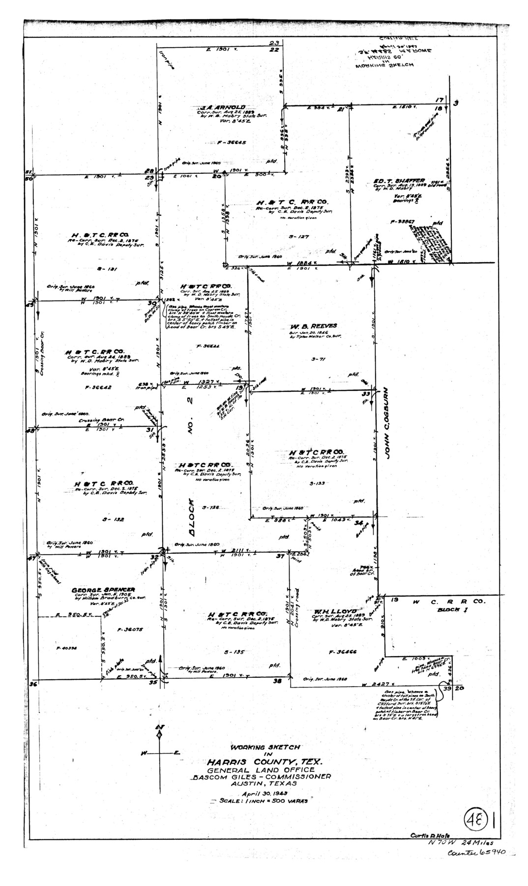
Harris County Working Sketch 48
-
Map/Doc
65940
-
Collection
General Map Collection
-
Object Dates
4/30/1943 (Creation Date)
-
People and Organizations
Curtis R. Hale (Draftsman)
-
Counties
Harris
-
Subjects
Surveying Working Sketch
-
Height x Width
26.8 x 16.0 inches
68.1 x 40.6 cm
-
Scale
1" = 500 varas
Part of: General Map Collection
Haskell County Working Sketch 11

Print $20.00
- Digital $50.00
Haskell County Working Sketch 11
1976
Size 38.0 x 33.4 inches
Map/Doc 66069
Current Miscellaneous File 74

Print $14.00
- Digital $50.00
Current Miscellaneous File 74
1850
Size 11.2 x 8.7 inches
Map/Doc 74181
San Saba County Sketch File 12

Print $6.00
- Digital $50.00
San Saba County Sketch File 12
Size 11.8 x 9.3 inches
Map/Doc 36439
Sabine County Rolled Sketch 2

Print $20.00
- Digital $50.00
Sabine County Rolled Sketch 2
1949
Size 33.3 x 20.8 inches
Map/Doc 7551
McCulloch County Working Sketch 8

Print $20.00
- Digital $50.00
McCulloch County Working Sketch 8
1977
Size 22.5 x 19.8 inches
Map/Doc 70683
Reeves County Boundary File 1

Print $12.00
- Digital $50.00
Reeves County Boundary File 1
Size 14.1 x 8.5 inches
Map/Doc 58195
Angelina County Working Sketch 46

Print $20.00
- Digital $50.00
Angelina County Working Sketch 46
1976
Size 31.2 x 31.3 inches
Map/Doc 67129
1882 Map of the Texas & Pacific R-Y Reserve

Print $20.00
- Digital $50.00
1882 Map of the Texas & Pacific R-Y Reserve
1887
Size 44.5 x 31.7 inches
Map/Doc 83559
Flight Mission No. DQO-8K, Frame 14, Galveston County

Print $20.00
- Digital $50.00
Flight Mission No. DQO-8K, Frame 14, Galveston County
1952
Size 18.7 x 22.4 inches
Map/Doc 85137
Burnet County Working Sketch 20

Print $40.00
- Digital $50.00
Burnet County Working Sketch 20
1983
Size 48.1 x 41.2 inches
Map/Doc 67863
Hardeman County Working Sketch 15

Print $40.00
- Digital $50.00
Hardeman County Working Sketch 15
1981
Size 42.9 x 49.1 inches
Map/Doc 63396
Fort Bend County Rolled Sketch 17

Print $20.00
- Digital $50.00
Fort Bend County Rolled Sketch 17
1997
Size 28.0 x 38.5 inches
Map/Doc 5901
You may also like
Randall County Rolled Sketch 5

Print $20.00
- Digital $50.00
Randall County Rolled Sketch 5
1945
Size 29.7 x 17.6 inches
Map/Doc 7425
McMullen County Working Sketch 13

Print $20.00
- Digital $50.00
McMullen County Working Sketch 13
1938
Size 27.2 x 21.6 inches
Map/Doc 70714
Erath County Working Sketch 31

Print $20.00
- Digital $50.00
Erath County Working Sketch 31
1970
Size 23.2 x 26.2 inches
Map/Doc 69112
Jim Wells County Working Sketch 10

Print $20.00
- Digital $50.00
Jim Wells County Working Sketch 10
1952
Size 18.7 x 17.8 inches
Map/Doc 66608


Your Opportunity - the Magic Valley - Money Will Grow on Trees! Learn Where How and Why!

Your Opportunity - the Magic Valley - Money Will Grow on Trees! Learn Where How and Why!
1928
Map/Doc 96740
Kinney County Working Sketch 42

Print $20.00
- Digital $50.00
Kinney County Working Sketch 42
1973
Size 20.4 x 33.7 inches
Map/Doc 70224
Rand McNally Standard Map of Texas

Print $20.00
- Digital $50.00
Rand McNally Standard Map of Texas
1926
Size 27.3 x 39.9 inches
Map/Doc 95855
Hutchinson County Working Sketch 19

Print $20.00
- Digital $50.00
Hutchinson County Working Sketch 19
1960
Size 18.8 x 18.3 inches
Map/Doc 66379
Van Zandt County Sketch File 5

Print $22.00
- Digital $50.00
Van Zandt County Sketch File 5
Size 20.5 x 6.3 inches
Map/Doc 39371
Denton County Working Sketch 29

Print $40.00
- Digital $50.00
Denton County Working Sketch 29
1987
Size 49.7 x 36.8 inches
Map/Doc 68634