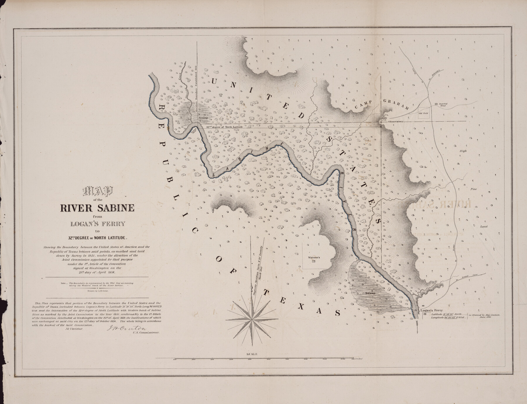
Map of the River Sabine from Logan's Ferry to 32nd Degree of North Latitude
-
Map/Doc
88902
-
Collection
Library of Congress
-
Object Dates
1841 (Creation Date)
-
People and Organizations
A.B. Gray (Draftsman)
-
Subjects
River Surveys Texas Boundaries
-
Height x Width
21.4 x 27.8 inches
54.4 x 70.6 cm
-
Comments
For more information see here. Prints available from the GLO courtesy of Library of Congress, Geography and Map Division.
Part of: Library of Congress
Map of Taylor County, Texas

Print $20.00
Map of Taylor County, Texas
1890
Size 22.0 x 18.1 inches
Map/Doc 93585
The railroad system of Texas on September 1st, 1883

Print $20.00
The railroad system of Texas on September 1st, 1883
1883
Size 20.1 x 26.8 inches
Map/Doc 93618
Colton's new map of the state of Texas, the Indian Territory and adjoining portions of New Mexico, Louisiana, and Arkansas

Print $20.00
Colton's new map of the state of Texas, the Indian Territory and adjoining portions of New Mexico, Louisiana, and Arkansas
1872
Size 31.1 x 36.6 inches
Map/Doc 93579

Perspective Map of Texarkana, Texas and Arkansas

Print $20.00
Perspective Map of Texarkana, Texas and Arkansas
1888
Size 18.1 x 29.2 inches
Map/Doc 93485
Hardeman Co[unty], Texas
![88946, Hardeman Co[unty], Texas, Library of Congress](https://historictexasmaps.com/wmedia_w700/maps/88946.tif.jpg)
Print $20.00
Hardeman Co[unty], Texas
1880
Size 27.8 x 23.7 inches
Map/Doc 88946
Maps showing Arkansas Central, the Helena & Corinth, and the Pine Bluff & Southwestern Railroads together forming the Texas & Northeastern Railway.

Print $20.00
Maps showing Arkansas Central, the Helena & Corinth, and the Pine Bluff & Southwestern Railroads together forming the Texas & Northeastern Railway.
1872
Size 26.8 x 29.1 inches
Map/Doc 93609
Perspective Map of the City of Laredo, Texas, the Gateway to and from Mexico

Print $20.00
Perspective Map of the City of Laredo, Texas, the Gateway to and from Mexico
1892
Size 24.0 x 36.7 inches
Map/Doc 93478
Map of Texas, showing the line of the Texas and New Orleans Rail Road, and its connections in the U.S. and adjacent territories.

Print $20.00
Map of Texas, showing the line of the Texas and New Orleans Rail Road, and its connections in the U.S. and adjacent territories.
1860
Size 22.0 x 31.1 inches
Map/Doc 93612
Map of Matagorda County, Texas

Print $20.00
Map of Matagorda County, Texas
1879
Size 30.7 x 27.4 inches
Map/Doc 88978
Plano del Lago de Sn. Bernardo situado en la costa del N. del Seno Mexicano su entrada en la L. N. de 28° 24' y en la Long. de 278° 27' segun el Meridiano de Tenerife

Print $20.00
Plano del Lago de Sn. Bernardo situado en la costa del N. del Seno Mexicano su entrada en la L. N. de 28° 24' y en la Long. de 278° 27' segun el Meridiano de Tenerife
Size 7.9 x 17.3 inches
Map/Doc 93616
[Map showing T&P Lands in El Paso County]
![88933, [Map showing T&P Lands in El Paso County], Library of Congress](https://historictexasmaps.com/wmedia_w700/maps/88933.tif.jpg)
Print $20.00
[Map showing T&P Lands in El Paso County]
Size 17.2 x 22.1 inches
Map/Doc 88933
You may also like
Clarkson's City Map of Port Aransas

Print $20.00
- Digital $50.00
Clarkson's City Map of Port Aransas
Size 18.5 x 26.5 inches
Map/Doc 3040
Atascosa County Rolled Sketch 20

Print $20.00
- Digital $50.00
Atascosa County Rolled Sketch 20
1956
Size 36.0 x 44.0 inches
Map/Doc 8432

Jasper County Rolled Sketch 2

Print $20.00
- Digital $50.00
Jasper County Rolled Sketch 2
1941
Size 37.9 x 24.1 inches
Map/Doc 6349
Travis County Rolled Sketch 41

Print $20.00
- Digital $50.00
Travis County Rolled Sketch 41
Size 31.3 x 24.7 inches
Map/Doc 8039
Tarrant County Working Sketch 25

Print $20.00
- Digital $50.00
Tarrant County Working Sketch 25
2004
Size 27.3 x 38.0 inches
Map/Doc 83585
Vehlein and Company Empresario Colony. December 21, 1826

Print $20.00
Vehlein and Company Empresario Colony. December 21, 1826
2020
Size 20.8 x 21.7 inches
Map/Doc 96007
[Sketch of Survey 9, Block Z3]
![93089, [Sketch of Survey 9, Block Z3], Twichell Survey Records](https://historictexasmaps.com/wmedia_w700/maps/93089-1.tif.jpg)
Print $2.00
- Digital $50.00
[Sketch of Survey 9, Block Z3]
Size 8.9 x 7.3 inches
Map/Doc 93089
Reagan County Rolled Sketch 10

Print $20.00
- Digital $50.00
Reagan County Rolled Sketch 10
1939
Size 18.7 x 15.8 inches
Map/Doc 7438
Cooke County Working Sketch 36

Print $20.00
- Digital $50.00
Cooke County Working Sketch 36
1992
Size 29.0 x 19.6 inches
Map/Doc 68273
Robertson & Scott V Ranch situated in Crosby County, Texas

Print $40.00
- Digital $50.00
Robertson & Scott V Ranch situated in Crosby County, Texas
Size 42.0 x 50.3 inches
Map/Doc 89753
Lynn County Boundary File 9

Print $24.00
- Digital $50.00
Lynn County Boundary File 9
Size 11.3 x 8.8 inches
Map/Doc 56657