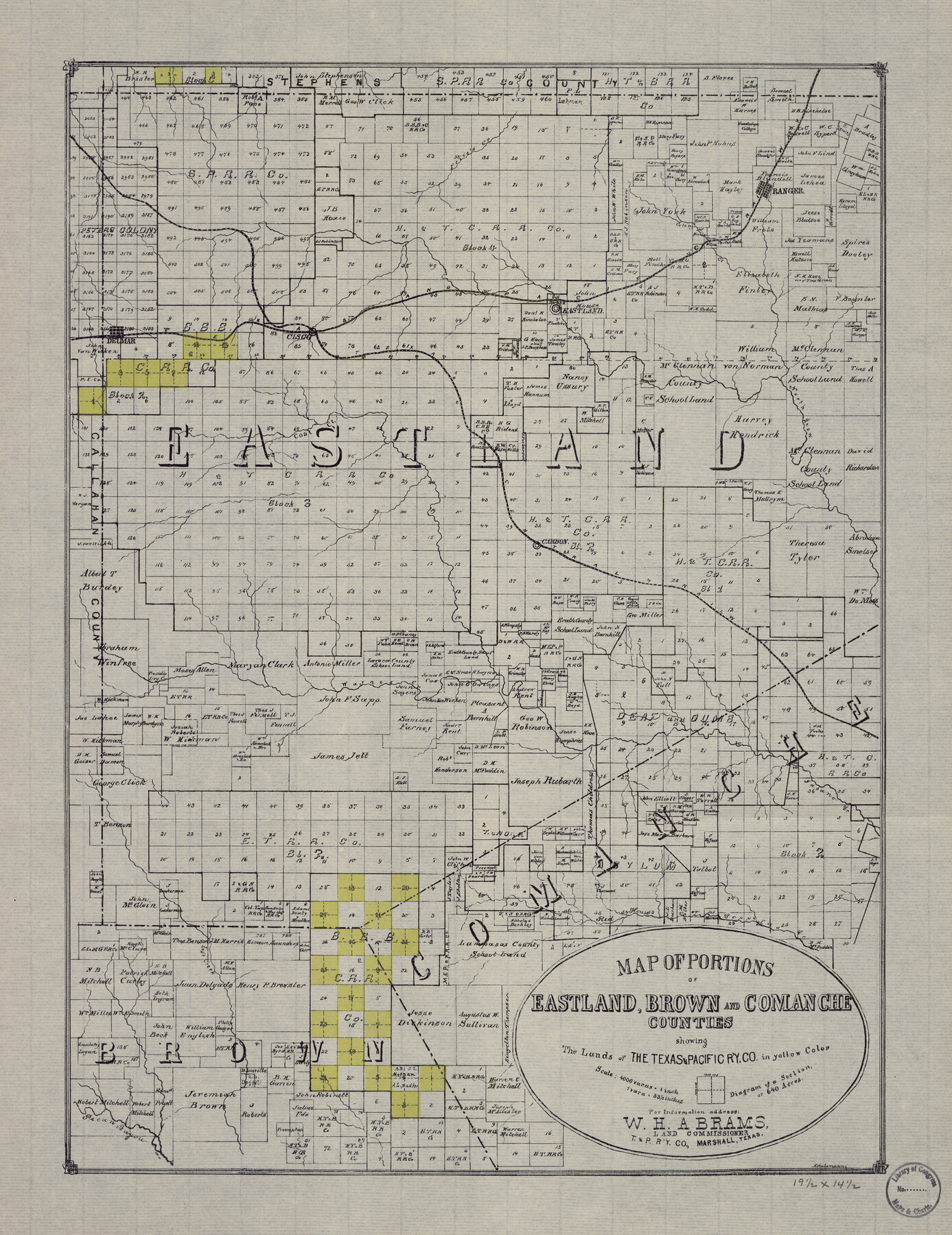
Map of Portions of Eastland, Brown and Comanche Counties
-
Map/Doc
88926
-
Collection
Library of Congress
-
People and Organizations
Texas and Pacific Railway Company (Publisher)
W.H. Abrams (Author)
-
Counties
Eastland Brown Comanche
-
Subjects
County
-
Height x Width
21.7 x 16.7 inches
55.1 x 42.4 cm
-
Comments
Prints available from the GLO courtesy of Library of Congress, Geography and Map Division. Shows the lands of the Texas and Pacific Ry. Co. in yellow color on map
Part of: Library of Congress

Map of western Texas and northern Mexico from authentical surveys

Print $20.00
Map of western Texas and northern Mexico from authentical surveys
1869
Size 27.2 x 31.9 inches
Map/Doc 93577
![88994, San Saba Co[unty], Library of Congress](https://historictexasmaps.com/wmedia_w700/maps/88994-1.tif.jpg)

Map of Maverick County

Print $20.00
Map of Maverick County
1893
Size 33.9 x 20.9 inches
Map/Doc 88979


Denison, Grayson County, Texas, 1891

Print $20.00
Denison, Grayson County, Texas, 1891
1891
Size 23.9 x 36.4 inches
Map/Doc 93480

Map of Caldwell County, Texas

Print $20.00
Map of Caldwell County, Texas
1880
Size 18.7 x 22.0 inches
Map/Doc 88915
Interpretative map of wind erodibility. Gaines County, Texas

Interpretative map of wind erodibility. Gaines County, Texas
1986
Size 27.6 x 36.2 inches
Map/Doc 93561
You may also like
The Rand-McNally New Commercial Atlas Map of Texas

Print $20.00
The Rand-McNally New Commercial Atlas Map of Texas
1914
Size 28.6 x 42.4 inches
Map/Doc 78225
Taylor County Sketch File 4

Print $2.00
- Digital $50.00
Taylor County Sketch File 4
Size 7.2 x 9.8 inches
Map/Doc 37780
![91655, [Capitol Lands], Twichell Survey Records](https://historictexasmaps.com/wmedia_w700/maps/91655-1.tif.jpg)
Presidio County Working Sketch 5

Print $20.00
- Digital $50.00
Presidio County Working Sketch 5
1917
Size 14.0 x 17.5 inches
Map/Doc 71679
Sketch in Uvalde County

Print $20.00
- Digital $50.00
Sketch in Uvalde County
1890
Size 12.3 x 15.9 inches
Map/Doc 5049
Starr County Rolled Sketch 31

Print $20.00
- Digital $50.00
Starr County Rolled Sketch 31
1941
Size 22.5 x 32.6 inches
Map/Doc 7828
Starr County Sketch File 6

Print $20.00
- Digital $50.00
Starr County Sketch File 6
Size 43.4 x 36.7 inches
Map/Doc 10605
Harris County Rolled Sketch 88

Print $20.00
- Digital $50.00
Harris County Rolled Sketch 88
1935
Size 34.4 x 22.7 inches
Map/Doc 6122
Map of the Mexican National R.R. "Laredo Route" and Connections. The Scenic Short Line to the City of Mexico

Print $20.00
- Digital $50.00
Map of the Mexican National R.R. "Laredo Route" and Connections. The Scenic Short Line to the City of Mexico
1901
Size 24.2 x 24.3 inches
Map/Doc 95145
Coke County Working Sketch 29

Print $20.00
- Digital $50.00
Coke County Working Sketch 29
1982
Size 19.6 x 25.4 inches
Map/Doc 68066
Flight Mission No. DIX-3P, Frame 164, Aransas County

Print $20.00
- Digital $50.00
Flight Mission No. DIX-3P, Frame 164, Aransas County
1956
Size 17.8 x 18.0 inches
Map/Doc 83770
Wheeler County Sketch File 5

Print $40.00
- Digital $50.00
Wheeler County Sketch File 5
1887
Size 20.2 x 24.2 inches
Map/Doc 12675