Interpretative map of wind erodibility. Gaines County, Texas

Interpretative map of wind erodibility. Gaines County, Texas
1986
Size: 27.6 x 36.2 inches
93561
The Villa and Presidio of San Antonio de Bexar

The Villa and Presidio of San Antonio de Bexar
1935
Size: 18.1 x 23.6 inches
93564
Map of the city of San Antonio, Bexar County, Texas including suburbs both north and south

Print $20.00
Map of the city of San Antonio, Bexar County, Texas including suburbs both north and south
1924
Size: 37.0 x 24.5 inches
93556
Aeroplane view of business district Amarillo, Texas

Print $20.00
Aeroplane view of business district Amarillo, Texas
1912
Size: 18.9 x 21.4 inches
93467
City and Harbor of Port Arthur Texas, Bird's Eye View Looking South to the Gulf of Mexico

Print $20.00
City and Harbor of Port Arthur Texas, Bird's Eye View Looking South to the Gulf of Mexico
1912
Size: 17.4 x 39.9 inches
93483
Boundaries between Brownsville, Texas and Matamoros, Tam. (Mexico)

Print $20.00
Boundaries between Brownsville, Texas and Matamoros, Tam. (Mexico)
1910
Size: 15.0 x 11.8 inches
93559
Map showing railroads and connecting lines of the Northern Texas Traction Co. from Ft. Worth to Dallas, Texas

Print $20.00
Map showing railroads and connecting lines of the Northern Texas Traction Co. from Ft. Worth to Dallas, Texas
1905
Size: 3.5 x 7.5 inches
93602
Nelson & White's Official Map of Beaumont

Print $40.00
Nelson & White's Official Map of Beaumont
1902
Size: 54.3 x 39.4 inches
93558
Map of the County of Galveston

Print $20.00
Map of the County of Galveston
1902
Size: 18.5 x 26.4 inches
93584
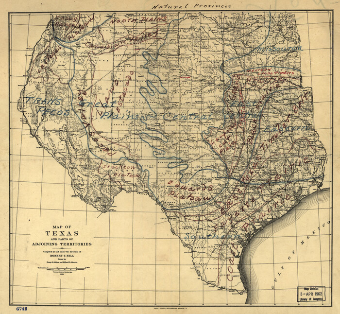
Natural provinces : [Texas].
Print $20.00
Natural provinces : [Texas].
1899
Size: 14.2 x 15.4 inches
93576
Map of Bexar County Showing Subdivisions of Original Surveys and Names of Present Owners

Print $20.00
Map of Bexar County Showing Subdivisions of Original Surveys and Names of Present Owners
1897
Size: 46.2 x 41.3 inches
88908
City of Houston and Environs

Print $20.00
City of Houston and Environs
1895
Size: 30.4 x 33.6 inches
93486
Interpretative map of wind erodibility. Gaines County, Texas
Interpretative map of wind erodibility. Gaines County, Texas
1986
-
Size
27.6 x 36.2 inches
-
Map/Doc
93561
-
Creation Date
1986
Literary Map of Texas

Literary Map of Texas
1955
-
Size
23.2 x 28.0 inches
-
Map/Doc
93563
-
Creation Date
1955
The Villa and Presidio of San Antonio de Bexar
The Villa and Presidio of San Antonio de Bexar
1935
-
Size
18.1 x 23.6 inches
-
Map/Doc
93564
-
Creation Date
1935
Railroad Map of Texas

Print $20.00
Railroad Map of Texas
1926
-
Size
40.6 x 42.5 inches
-
Map/Doc
93619
-
Creation Date
1926
Map of the city of San Antonio, Bexar County, Texas including suburbs both north and south
Print $20.00
Map of the city of San Antonio, Bexar County, Texas including suburbs both north and south
1924
-
Size
37.0 x 24.5 inches
-
Map/Doc
93556
-
Creation Date
1924
Gillespie County

Print $40.00
Gillespie County
1918
-
Size
38.1 x 48.3 inches
-
Map/Doc
88942
-
Creation Date
1918
Aeroplane view of business district Amarillo, Texas
Print $20.00
Aeroplane view of business district Amarillo, Texas
1912
-
Size
18.9 x 21.4 inches
-
Map/Doc
93467
-
Creation Date
1912
City and Harbor of Port Arthur Texas, Bird's Eye View Looking South to the Gulf of Mexico
Print $20.00
City and Harbor of Port Arthur Texas, Bird's Eye View Looking South to the Gulf of Mexico
1912
-
Size
17.4 x 39.9 inches
-
Map/Doc
93483
-
Creation Date
1912
Houston - a Modern City

Print $20.00
Houston - a Modern City
1912
-
Size
18.2 x 23.4 inches
-
Map/Doc
93482
-
Creation Date
1912
Boundaries between Brownsville, Texas and Matamoros, Tam. (Mexico)
Print $20.00
Boundaries between Brownsville, Texas and Matamoros, Tam. (Mexico)
1910
-
Size
15.0 x 11.8 inches
-
Map/Doc
93559
-
Creation Date
1910
Map showing railroads and connecting lines of the Northern Texas Traction Co. from Ft. Worth to Dallas, Texas
Print $20.00
Map showing railroads and connecting lines of the Northern Texas Traction Co. from Ft. Worth to Dallas, Texas
1905
-
Size
3.5 x 7.5 inches
-
Map/Doc
93602
-
Creation Date
1905
Nelson & White's Official Map of Beaumont
Print $40.00
Nelson & White's Official Map of Beaumont
1902
-
Size
54.3 x 39.4 inches
-
Map/Doc
93558
-
Creation Date
1902
Map of the County of Galveston
Print $20.00
Map of the County of Galveston
1902
-
Size
18.5 x 26.4 inches
-
Map/Doc
93584
-
Creation Date
1902
Texas Railroads

Print $20.00
Texas Railroads
1900
-
Size
19.7 x 26.8 inches
-
Map/Doc
93598
-
Creation Date
1900
Natural provinces : [Texas].
Print $20.00
Natural provinces : [Texas].
1899
-
Size
14.2 x 15.4 inches
-
Map/Doc
93576
-
Creation Date
1899
Hardin County

Print $20.00
Hardin County
1898
-
Size
40.0 x 45.5 inches
-
Map/Doc
88947
-
Creation Date
1898
Map of Bexar County Showing Subdivisions of Original Surveys and Names of Present Owners
Print $20.00
Map of Bexar County Showing Subdivisions of Original Surveys and Names of Present Owners
1897
-
Size
46.2 x 41.3 inches
-
Map/Doc
88908
-
Creation Date
1897
Map of Dimmit County

Print $20.00
Map of Dimmit County
1897
-
Size
17.3 x 21.8 inches
-
Map/Doc
88924
-
Creation Date
1897
Map of Eastland Co[unty]
![88929, Map of Eastland Co[unty], Library of Congress](https://historictexasmaps.com/wmedia_w700/maps/88929.tif.jpg)
Print $20.00
Map of Eastland Co[unty]
1896
-
Size
45.0 x 42.8 inches
-
Map/Doc
88929
-
Creation Date
1896
Map of Hidalgo County

Print $20.00
Map of Hidalgo County
1896
-
Size
43.5 x 25.3 inches
-
Map/Doc
88954
-
Creation Date
1896
Kaufman County

Print $20.00
Kaufman County
1896
-
Size
43.7 x 30.2 inches
-
Map/Doc
88964
-
Creation Date
1896
Map of McLennan Co[unty]
![88974, Map of McLennan Co[unty], Library of Congress](https://historictexasmaps.com/wmedia_w700/maps/88974.tif.jpg)
Print $40.00
Map of McLennan Co[unty]
1896
-
Size
47.9 x 53.6 inches
-
Map/Doc
88974
-
Creation Date
1896
Map of Liberty County

Print $20.00
Map of Liberty County
1895
-
Size
25.9 x 27.5 inches
-
Map/Doc
88968
-
Creation Date
1895
City of Houston and Environs
Print $20.00
City of Houston and Environs
1895
-
Size
30.4 x 33.6 inches
-
Map/Doc
93486
-
Creation Date
1895
Bowie County

Print $20.00
Bowie County
1894
-
Size
17.5 x 22.4 inches
-
Map/Doc
88911
-
Creation Date
1894
Map of Martin County

Print $20.00
Map of Martin County
1894
-
Size
22.3 x 17.3 inches
-
Map/Doc
88977
-
Creation Date
1894
Hood Co[unty]
![88956, Hood Co[unty], Library of Congress](https://historictexasmaps.com/wmedia_w700/maps/88956.tif.jpg)
Print $20.00
Hood Co[unty]
1894
-
Size
18.5 x 17.4 inches
-
Map/Doc
88956
-
Creation Date
1894
Motley Co[unty]
![88982, Motley Co[unty], Library of Congress](https://historictexasmaps.com/wmedia_w700/maps/88982.tif.jpg)
Print $20.00
Motley Co[unty]
1893
-
Size
38.5 x 32.0 inches
-
Map/Doc
88982
-
Creation Date
1893
Map of Maverick County

Print $20.00
Map of Maverick County
1893
-
Size
33.9 x 20.9 inches
-
Map/Doc
88979
-
Creation Date
1893
Hartley Co[unty]
![88949, Hartley Co[unty], Library of Congress](https://historictexasmaps.com/wmedia_w700/maps/88949.tif.jpg)
Print $20.00
Hartley Co[unty]
1892
-
Size
19.4 x 24.4 inches
-
Map/Doc
88949
-
Creation Date
1892