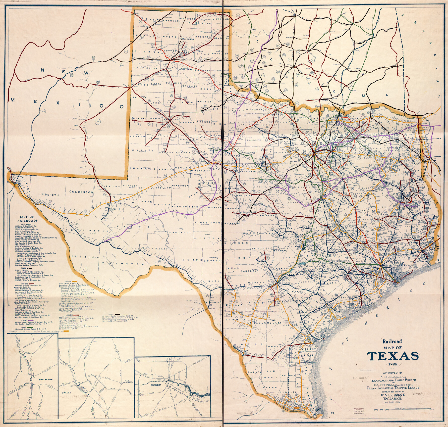
Railroad Map of Texas
-
Map/Doc
93619
-
Collection
Library of Congress
-
Object Dates
1926 (Creation Date)
-
People and Organizations
Ira D. Dodge (Publisher)
Ira D. Dodge (Author)
-
Subjects
Railroads State of Texas
-
Height x Width
40.6 x 42.5 inches
103.1 x 108.0 cm
-
Comments
For more information see here.
Part of: Library of Congress
Houston, Texas (Looking South)

Print $20.00
Houston, Texas (Looking South)
1891
Size 41.1 x 25.3 inches
Map/Doc 93465
Map of Callahan Co[unty]
![88916, Map of Callahan Co[unty], Library of Congress](https://historictexasmaps.com/wmedia_w700/maps/88916.tif.jpg)
Print $20.00
Map of Callahan Co[unty]
1879
Size 24.7 x 18.5 inches
Map/Doc 88916
Perspective Map of Texarkana, Texas and Arkansas

Print $20.00
Perspective Map of Texarkana, Texas and Arkansas
1888
Size 18.1 x 29.2 inches
Map/Doc 93485
Map showing the Atchison, Topeka and Santa Fe Railroad system, with its connections.

Print $20.00
Map showing the Atchison, Topeka and Santa Fe Railroad system, with its connections.
1883
Size 22.0 x 29.1 inches
Map/Doc 93583

J. De Cordova's Map of the State of Texas Compiled from the records of the General Land Office of the State

Print $20.00
J. De Cordova's Map of the State of Texas Compiled from the records of the General Land Office of the State
1853
Size 35.0 x 35.0 inches
Map/Doc 88903

Schönberg's map of Texas.

Print $20.00
Schönberg's map of Texas.
1866
Size 11.0 x 13.0 inches
Map/Doc 93575


![88940, Fisher Co[unty], Library of Congress](https://historictexasmaps.com/wmedia_w700/maps/88940.tif.jpg)

You may also like
Crockett County Working Sketch 72

Print $20.00
- Digital $50.00
Crockett County Working Sketch 72
1963
Size 43.9 x 38.5 inches
Map/Doc 68405
Coke County Working Sketch 11

Print $20.00
- Digital $50.00
Coke County Working Sketch 11
1945
Size 40.9 x 40.2 inches
Map/Doc 68048
Culberson County Working Sketch 88

Print $20.00
- Digital $50.00
Culberson County Working Sketch 88
1983
Size 32.8 x 37.1 inches
Map/Doc 68542
Genl. Austins Map of Texas With Parts of the Adjoining States

Print $20.00
- Digital $50.00
Genl. Austins Map of Texas With Parts of the Adjoining States
1840
Size 30.6 x 25.3 inches
Map/Doc 93860
Jefferson County Rolled Sketch 46

Print $3.00
- Digital $50.00
Jefferson County Rolled Sketch 46
Size 15.7 x 10.0 inches
Map/Doc 9304
[Township 2 North, Block 33]
![91209, [Township 2 North, Block 33], Twichell Survey Records](https://historictexasmaps.com/wmedia_w700/maps/91209-1.tif.jpg)
Print $3.00
- Digital $50.00
[Township 2 North, Block 33]
Size 11.2 x 13.4 inches
Map/Doc 91209
Real County Rolled Sketch 10

Print $20.00
- Digital $50.00
Real County Rolled Sketch 10
Size 43.7 x 34.3 inches
Map/Doc 9835

Parker County Working Sketch 28

Print $20.00
- Digital $50.00
Parker County Working Sketch 28
2009
Map/Doc 89011
Newton County Working Sketch 28

Print $40.00
- Digital $50.00
Newton County Working Sketch 28
1954
Size 34.7 x 55.0 inches
Map/Doc 71274
Hockley County Rolled Sketch 9

Print $20.00
- Digital $50.00
Hockley County Rolled Sketch 9
1947
Size 21.2 x 16.5 inches
Map/Doc 6218
Flight Mission No. CUG-2P, Frame 61, Kleberg County

Print $20.00
- Digital $50.00
Flight Mission No. CUG-2P, Frame 61, Kleberg County
1956
Size 18.5 x 22.2 inches
Map/Doc 86198