Hockley County Rolled Sketch 9
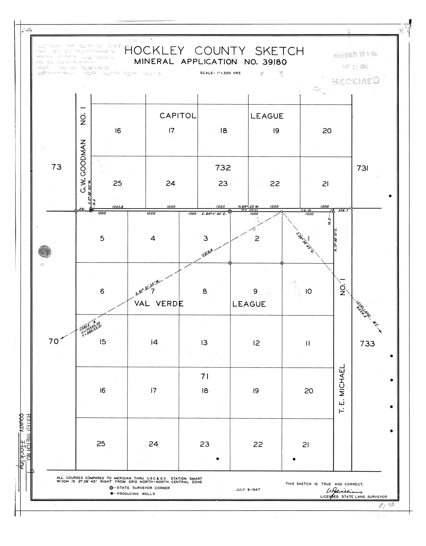
Hockley County Sketch - Mineral Application No. 39180
-
Map/Doc
6218
-
Collection
General Map Collection
-
Object Dates
1947/7/8 (Creation Date)
1947/7/26 (File Date)
-
People and Organizations
W.J. Williams (Surveyor/Engineer)
-
Counties
Hockley
-
Subjects
Surveying Rolled Sketch
-
Height x Width
21.2 x 16.5 inches
53.8 x 41.9 cm
-
Scale
1" = 500 varas
Part of: General Map Collection
Andrews County Working Sketch 13

Print $20.00
- Digital $50.00
Andrews County Working Sketch 13
1956
Size 37.3 x 30.6 inches
Map/Doc 67059
Tom Green County Working Sketch 7

Print $20.00
- Digital $50.00
Tom Green County Working Sketch 7
1949
Size 32.2 x 31.7 inches
Map/Doc 69376
Lloyd's New Military Map of the Border & Southern States

Print $20.00
- Digital $50.00
Lloyd's New Military Map of the Border & Southern States
1864
Size 32.4 x 44.0 inches
Map/Doc 97517
United States

Print $40.00
- Digital $50.00
United States
1961
Size 55.0 x 81.2 inches
Map/Doc 75922
Flight Mission No. DQO-12K, Frame 35, Galveston County

Print $20.00
- Digital $50.00
Flight Mission No. DQO-12K, Frame 35, Galveston County
1952
Size 18.7 x 22.4 inches
Map/Doc 85226
Coast Chart No. 212 - From Latitude 26° 33' to the Rio Grande Texas

Print $20.00
- Digital $50.00
Coast Chart No. 212 - From Latitude 26° 33' to the Rio Grande Texas
1886
Size 18.3 x 24.1 inches
Map/Doc 72835
Potter County Boundary File 3

Print $10.00
- Digital $50.00
Potter County Boundary File 3
Size 5.8 x 8.9 inches
Map/Doc 57974
Crane County Working Sketch 17

Print $20.00
- Digital $50.00
Crane County Working Sketch 17
1957
Size 10.7 x 37.0 inches
Map/Doc 63911
Flight Mission No. CLL-1N, Frame 188, Willacy County

Print $20.00
- Digital $50.00
Flight Mission No. CLL-1N, Frame 188, Willacy County
1954
Size 18.4 x 22.0 inches
Map/Doc 87058
Borden County

Print $20.00
- Digital $50.00
Borden County
1922
Size 44.7 x 38.7 inches
Map/Doc 66718
Pecos County Rolled Sketch 174

Print $20.00
- Digital $50.00
Pecos County Rolled Sketch 174
Size 23.3 x 25.0 inches
Map/Doc 7294

You may also like
[Beaumont, Sour Lake and Western Ry. Right of Way and Alignment - Frisco]
![64118, [Beaumont, Sour Lake and Western Ry. Right of Way and Alignment - Frisco], General Map Collection](https://historictexasmaps.com/wmedia_w700/maps/64118.tif.jpg)
Print $20.00
- Digital $50.00
[Beaumont, Sour Lake and Western Ry. Right of Way and Alignment - Frisco]
1910
Size 20.1 x 46.1 inches
Map/Doc 64118
Harris County Working Sketch 125

Print $20.00
- Digital $50.00
Harris County Working Sketch 125
1995
Size 42.0 x 34.0 inches
Map/Doc 66017
Presidio County Rolled Sketch 115

Print $20.00
- Digital $50.00
Presidio County Rolled Sketch 115
1980
Size 19.3 x 22.2 inches
Map/Doc 7391
Culberson County Working Sketch 7

Print $20.00
- Digital $50.00
Culberson County Working Sketch 7
1912
Size 21.2 x 17.7 inches
Map/Doc 68459
Brewster County Sketch File NS-4

Print $40.00
- Digital $50.00
Brewster County Sketch File NS-4
1929
Size 17.8 x 22.8 inches
Map/Doc 10987
Cameron County NRC Article 33.136 Sketch 2

Print $20.00
- Digital $50.00
Cameron County NRC Article 33.136 Sketch 2
2002
Size 24.4 x 35.9 inches
Map/Doc 77040
Flight Mission No. BRA-7M, Frame 120, Jefferson County

Print $20.00
- Digital $50.00
Flight Mission No. BRA-7M, Frame 120, Jefferson County
1953
Size 18.7 x 22.4 inches
Map/Doc 85514
Sectional map of Texas traversed by the Missouri, Kansas & Texas Railway, showing the crops adapted to each section, with the elevation and annual rainfall

Print $20.00
- Digital $50.00
Sectional map of Texas traversed by the Missouri, Kansas & Texas Railway, showing the crops adapted to each section, with the elevation and annual rainfall
1904
Size 21.9 x 22.6 inches
Map/Doc 95813
Flight Mission No. CUG-3P, Frame 164, Kleberg County

Print $20.00
- Digital $50.00
Flight Mission No. CUG-3P, Frame 164, Kleberg County
1956
Size 18.5 x 22.2 inches
Map/Doc 86284
[Blocks A, RG, O, B, S and 11]
![92858, [Blocks A, RG, O, B, S and 11], Twichell Survey Records](https://historictexasmaps.com/wmedia_w700/maps/92858-1.tif.jpg)
Print $20.00
- Digital $50.00
[Blocks A, RG, O, B, S and 11]
1921
Size 25.2 x 15.5 inches
Map/Doc 92858
Comanche County Sketch File 19 3/4

Print $40.00
- Digital $50.00
Comanche County Sketch File 19 3/4
Size 15.7 x 12.9 inches
Map/Doc 19101
Galveston County Sketch File 13

Print $20.00
- Digital $50.00
Galveston County Sketch File 13
Size 16.2 x 12.5 inches
Map/Doc 11530