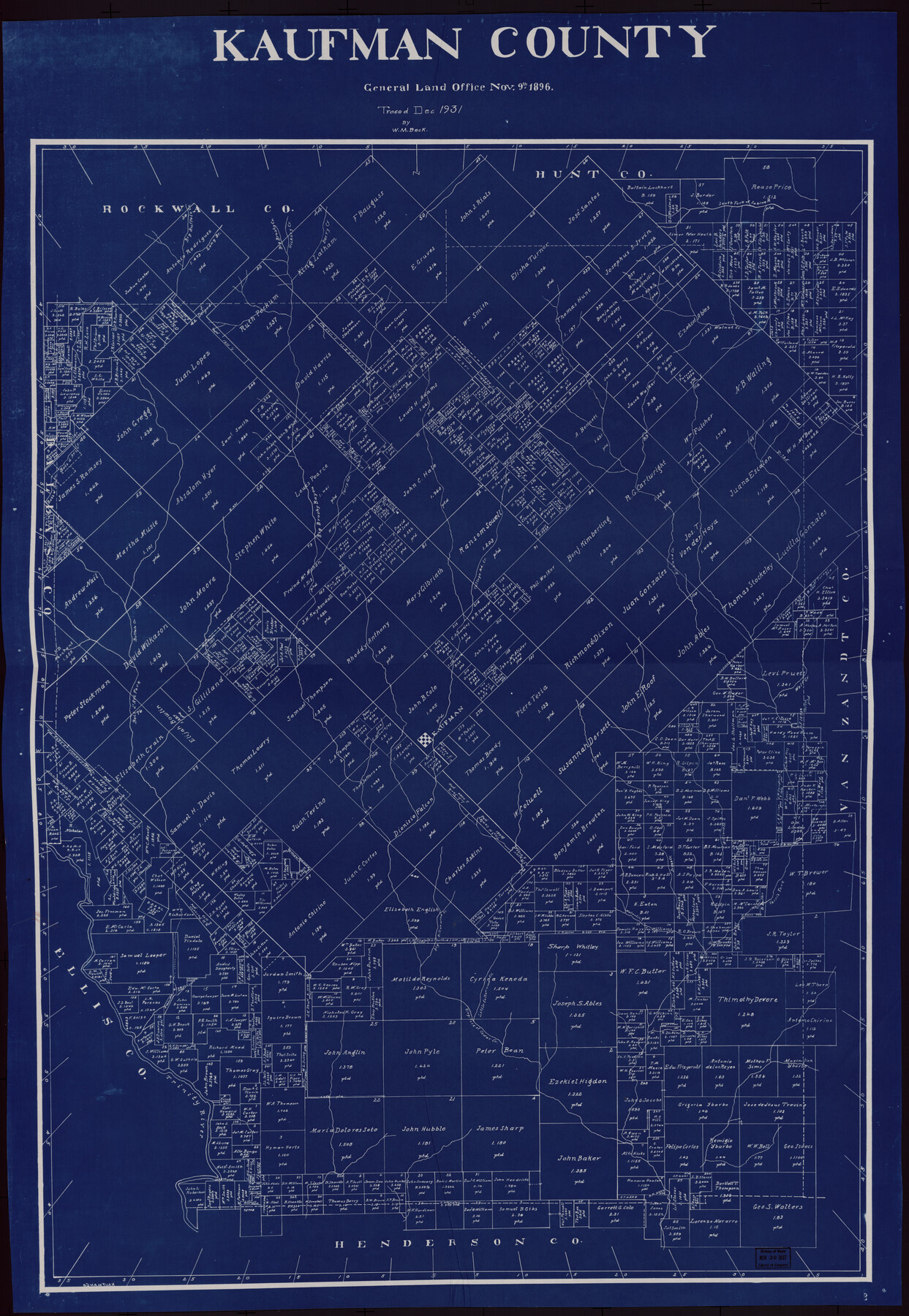
Kaufman County
-
Map/Doc
88964
-
Collection
Library of Congress
-
Object Dates
11/9/1896 (Creation Date)
-
People and Organizations
General Land Office (Publisher)
W.M. Beck (Draftsman)
-
Counties
Kaufman
-
Subjects
County
-
Height x Width
43.7 x 30.2 inches
111.0 x 76.7 cm
-
Comments
Prints available from the GLO courtesy of Library of Congress, Geography and Map Division. Traced in Dec. 1931.
Part of: Library of Congress


Map of Wilbarger County, Texas

Print $20.00
Map of Wilbarger County, Texas
1887
Size 11.8 x 8.7 inches
Map/Doc 93587
Greenville, Tex., County Seat of Hunt County, 1886

Print $20.00
Greenville, Tex., County Seat of Hunt County, 1886
1886
Size 20.4 x 28.3 inches
Map/Doc 93476
Denison, Texas, Grayson County 1886

Print $20.00
Denison, Texas, Grayson County 1886
1886
Size 21.1 x 30.5 inches
Map/Doc 93466
A Map of Mexico, Louisiana and the Missouri Territory, including also the State of Mississippi, Alabama Territory, East & West Florida, Georgia, South Carolina & part of the Island of Cuba

Print $40.00
A Map of Mexico, Louisiana and the Missouri Territory, including also the State of Mississippi, Alabama Territory, East & West Florida, Georgia, South Carolina & part of the Island of Cuba
Size 66.9 x 64.2 inches
Map/Doc 95312
Preliminary Chart of the Northwestern Part of the Gulf of Mexico - Unfinished Proof

Print $40.00
Preliminary Chart of the Northwestern Part of the Gulf of Mexico - Unfinished Proof
1861
Size 31.5 x 68.9 inches
Map/Doc 95308
Map exhibiting the fixed location of the main trunk of the New-Orleans, Opelousas & Great Western Railroad of Louisiana…

Print $20.00
Map exhibiting the fixed location of the main trunk of the New-Orleans, Opelousas & Great Western Railroad of Louisiana…
1859
Size 25.2 x 37.0 inches
Map/Doc 93582


Map of Hamilton County

Print $20.00
Map of Hamilton County
1876
Size 19.0 x 22.2 inches
Map/Doc 88945
Map of McMullen County

Print $20.00
Map of McMullen County
1879
Size 28.6 x 19.3 inches
Map/Doc 88975
You may also like
Map of Navarro County

Print $20.00
- Digital $50.00
Map of Navarro County
1858
Size 19.3 x 25.8 inches
Map/Doc 3912
[Surveys in Power and Hewetson's Colony along the Blanco and Medina Rivers]
![46, [Surveys in Power and Hewetson's Colony along the Blanco and Medina Rivers], General Map Collection](https://historictexasmaps.com/wmedia_w700/maps/46.tif.jpg)
Print $20.00
- Digital $50.00
[Surveys in Power and Hewetson's Colony along the Blanco and Medina Rivers]
1834
Size 37.0 x 29.9 inches
Map/Doc 46
Galveston County NRC Article 33.136 Sketch 83

Print $52.00
- Digital $50.00
Galveston County NRC Article 33.136 Sketch 83
2016
Size 22.5 x 34.0 inches
Map/Doc 94968
[Pecos River Bed]
![2467, [Pecos River Bed], General Map Collection](https://historictexasmaps.com/wmedia_w700/maps/2467.tif.jpg)
Print $20.00
- Digital $50.00
[Pecos River Bed]
Size 16.6 x 39.8 inches
Map/Doc 2467
Wharton County Sketch File A4

Print $11.00
- Digital $50.00
Wharton County Sketch File A4
1904
Size 11.0 x 8.4 inches
Map/Doc 39981
Rio Grande, North Extension McAllen Sheet

Print $20.00
- Digital $50.00
Rio Grande, North Extension McAllen Sheet
1937
Size 18.5 x 42.1 inches
Map/Doc 65108
Austin Map and Street Guide [Recto]
![94162, Austin Map and Street Guide [Recto], General Map Collection](https://historictexasmaps.com/wmedia_w700/maps/94162.tif.jpg)
Austin Map and Street Guide [Recto]
1976
Size 35.4 x 22.7 inches
Map/Doc 94162
San Jacinto County Working Sketch Graphic Index

Print $20.00
- Digital $50.00
San Jacinto County Working Sketch Graphic Index
1942
Size 44.9 x 40.6 inches
Map/Doc 76691
J. B. Chilton's Subdivision of League 289, Gaines County, Texas

Print $20.00
- Digital $50.00
J. B. Chilton's Subdivision of League 289, Gaines County, Texas
1924
Size 18.7 x 24.7 inches
Map/Doc 92682
Flight Mission No. DCL-6C, Frame 6, Kenedy County

Print $20.00
- Digital $50.00
Flight Mission No. DCL-6C, Frame 6, Kenedy County
1943
Size 18.6 x 22.3 inches
Map/Doc 85866
The Chief Justice County of Goliad. Proposed, No Date

Print $20.00
The Chief Justice County of Goliad. Proposed, No Date
2020
Size 14.7 x 21.7 inches
Map/Doc 96046
Burleson County Working Sketch 44

Print $20.00
- Digital $50.00
Burleson County Working Sketch 44
1991
Size 22.4 x 25.0 inches
Map/Doc 67763