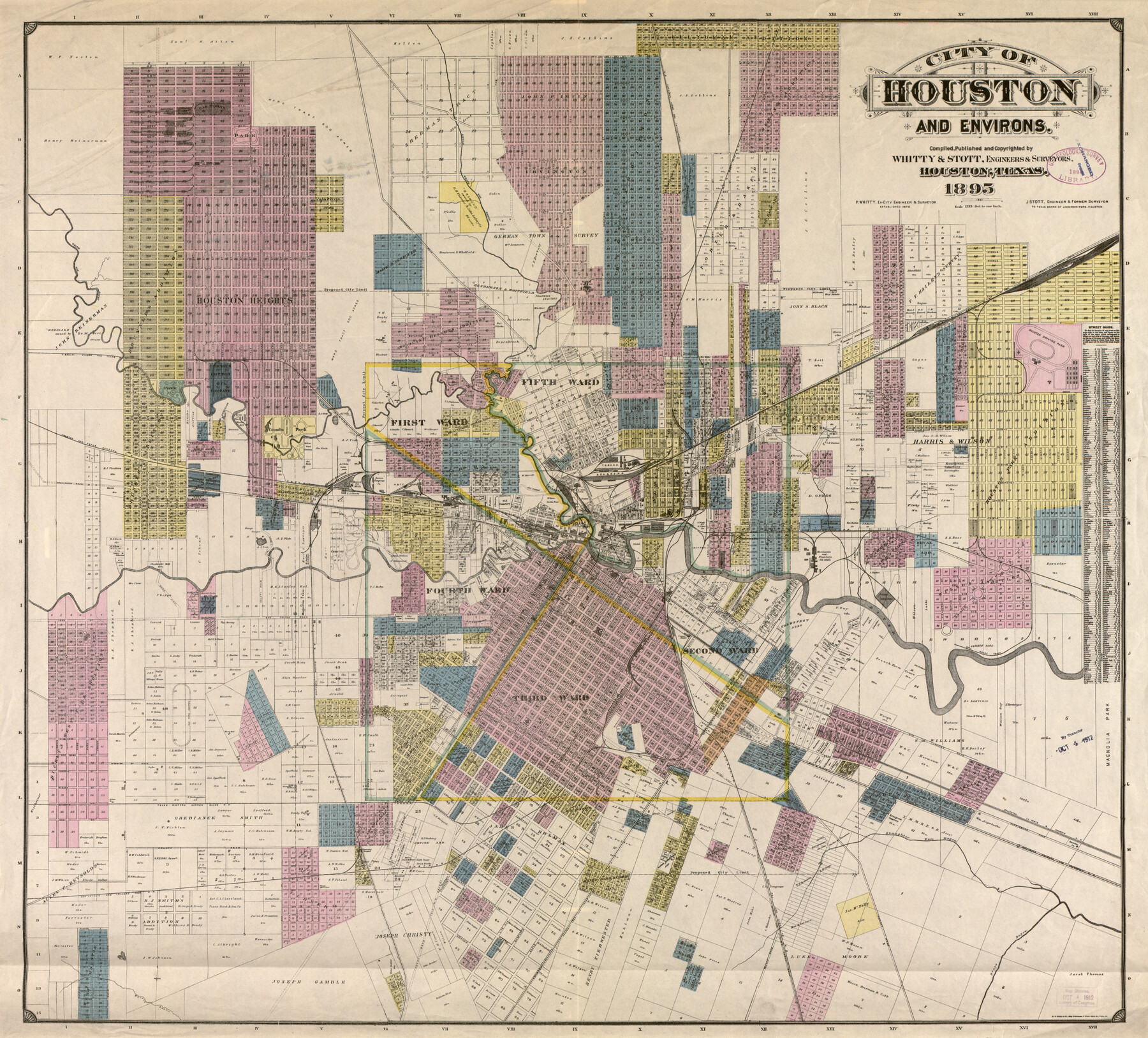
City of Houston and Environs
-
Map/Doc
93486
-
Collection
Library of Congress
-
Object Dates
1895 (Creation Date)
-
People and Organizations
Whitty and Stott (Publisher)
Whitty and Stott (Draftsman)
Whitty and Stott (Compiler)
-
Counties
Harris
-
Subjects
City
-
Height x Width
30.4 x 33.6 inches
77.2 x 85.3 cm
-
Comments
For more information see here. Prints available from the GLO courtesy of Library of Congress, Geography and Map Division.
Part of: Library of Congress
Red River County, Texas

Print $20.00
Red River County, Texas
1870
Size 22.4 x 17.3 inches
Map/Doc 88989
Map of McMullen County

Print $20.00
Map of McMullen County
1879
Size 28.6 x 19.3 inches
Map/Doc 88975

Panorama of the seat of war - Birds eye view of Texas and part of Mexico

Print $20.00
Panorama of the seat of war - Birds eye view of Texas and part of Mexico
1861
Size 21.6 x 28.9 inches
Map/Doc 93360
Map of the River Sabine from Logan's Ferry to 32nd Degree of North Latitude

Print $20.00
Map of the River Sabine from Logan's Ferry to 32nd Degree of North Latitude
1841
Size 21.4 x 27.8 inches
Map/Doc 88902
Fort Worth, Tex. "The Queen of the Prairies", County Seat of Tarrant County

Print $20.00
Fort Worth, Tex. "The Queen of the Prairies", County Seat of Tarrant County
1886
Size 28.8 x 38.6 inches
Map/Doc 93470
Map of Kinney County, Texas

Print $20.00
Map of Kinney County, Texas
1884
Size 25.4 x 35.2 inches
Map/Doc 88966
Map showing the Atchison, Topeka and Santa Fe Railroad system, with its connections.

Print $20.00
Map showing the Atchison, Topeka and Santa Fe Railroad system, with its connections.
1883
Size 22.0 x 29.1 inches
Map/Doc 93583
[Map showing T&P Lands in El Paso County]
![88933, [Map showing T&P Lands in El Paso County], Library of Congress](https://historictexasmaps.com/wmedia_w700/maps/88933.tif.jpg)
Print $20.00
[Map showing T&P Lands in El Paso County]
Size 17.2 x 22.1 inches
Map/Doc 88933


Carte de la côte de la Louisiane depuis la Baye St. Joseph, jusqu'à celle de St. Bernard où tous les ports et bons mouillages sont marquez par des ancres; avec la quantité de piés d'eau que l'on y trouve.

Print $20.00
Carte de la côte de la Louisiane depuis la Baye St. Joseph, jusqu'à celle de St. Bernard où tous les ports et bons mouillages sont marquez par des ancres; avec la quantité de piés d'eau que l'on y trouve.
1732
Size 11.4 x 32.7 inches
Map/Doc 93607
You may also like
Travis County Rolled Sketch 18

Print $20.00
- Digital $50.00
Travis County Rolled Sketch 18
1940
Size 28.8 x 21.1 inches
Map/Doc 8020
Ector County Working Sketch 3

Print $20.00
- Digital $50.00
Ector County Working Sketch 3
1940
Size 26.4 x 31.2 inches
Map/Doc 68846
Township No. 2 South Range No. 23 West of the Indian Meridian

Print $20.00
- Digital $50.00
Township No. 2 South Range No. 23 West of the Indian Meridian
1875
Size 19.3 x 24.4 inches
Map/Doc 75175
San Jacinto County Rolled Sketch 14

Print $20.00
- Digital $50.00
San Jacinto County Rolled Sketch 14
1998
Size 30.0 x 42.7 inches
Map/Doc 7563
Crockett County Sketch File 42

Print $28.00
- Digital $50.00
Crockett County Sketch File 42
Size 12.8 x 8.4 inches
Map/Doc 19755
Flight Mission No. CGI-3N, Frame 126, Cameron County

Print $20.00
- Digital $50.00
Flight Mission No. CGI-3N, Frame 126, Cameron County
1954
Size 18.5 x 22.1 inches
Map/Doc 84599
Edwards County Sketch File 52

Print $20.00
- Digital $50.00
Edwards County Sketch File 52
1972
Size 19.9 x 35.1 inches
Map/Doc 11446
Throckmorton County Boundary File 2

Print $34.00
- Digital $50.00
Throckmorton County Boundary File 2
Size 8.3 x 5.7 inches
Map/Doc 59264
Shelby County Rolled Sketch 9

Print $20.00
- Digital $50.00
Shelby County Rolled Sketch 9
Size 23.0 x 19.1 inches
Map/Doc 7777
Nueces County Working Sketch Graphic Index

Print $20.00
- Digital $50.00
Nueces County Working Sketch Graphic Index
1913
Size 24.0 x 32.3 inches
Map/Doc 76655
Map of Chambers County

Print $20.00
- Digital $50.00
Map of Chambers County
1896
Size 22.2 x 23.3 inches
Map/Doc 3385
Harris County NRC Article 33.136 Location Key Sheet

Print $20.00
- Digital $50.00
Harris County NRC Article 33.136 Location Key Sheet
1995
Size 27.0 x 21.8 inches
Map/Doc 77027