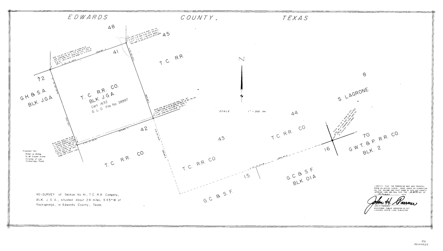
Edwards County Sketch File 52
Re-Survey of section No. 41, T.C. R.R. Company, Blk. J. G. A.
-
Map/Doc
11446
-
Collection
General Map Collection
-
Object Dates
1972/10/26 (Creation Date)
1972/11/7 (File Date)
-
People and Organizations
John H. Poerner (Surveyor/Engineer)
-
Counties
Edwards
-
Subjects
Surveying Sketch File
-
Height x Width
19.9 x 35.1 inches
50.5 x 89.2 cm
-
Medium
paper, photocopy
-
Scale
1:300
Part of: General Map Collection
Duval County Boundary File 3

Print $14.00
- Digital $50.00
Duval County Boundary File 3
Size 8.6 x 3.9 inches
Map/Doc 52719
Hutchinson County Working Sketch 48

Print $20.00
- Digital $50.00
Hutchinson County Working Sketch 48
1981
Size 36.7 x 29.5 inches
Map/Doc 66408
Flight Mission No. CRC-5R, Frame 25, Chambers County

Print $20.00
- Digital $50.00
Flight Mission No. CRC-5R, Frame 25, Chambers County
1956
Size 18.9 x 22.4 inches
Map/Doc 84947
Fannin County

Print $20.00
- Digital $50.00
Fannin County
1946
Size 44.0 x 38.6 inches
Map/Doc 95495
Lynn County Sketch File 22

Print $2.00
- Digital $50.00
Lynn County Sketch File 22
1994
Size 11.1 x 8.8 inches
Map/Doc 30553
Goliad County Sketch File 22

Print $12.00
- Digital $50.00
Goliad County Sketch File 22
1855
Size 12.8 x 8.1 inches
Map/Doc 24289
Coryell County Working Sketch 18

Print $20.00
- Digital $50.00
Coryell County Working Sketch 18
1965
Size 24.6 x 34.3 inches
Map/Doc 68225
Angelina County Working Sketch 49

Print $20.00
- Digital $50.00
Angelina County Working Sketch 49
1980
Size 38.2 x 29.5 inches
Map/Doc 67132
Reagan County Rolled Sketch 29B

Print $20.00
- Digital $50.00
Reagan County Rolled Sketch 29B
1955
Size 36.5 x 36.1 inches
Map/Doc 9826
Roberts County Rolled Sketch 6

Print $20.00
- Digital $50.00
Roberts County Rolled Sketch 6
2018
Map/Doc 97395
Brewster County Working Sketch 12

Print $20.00
- Digital $50.00
Brewster County Working Sketch 12
1924
Size 36.9 x 21.4 inches
Map/Doc 67545
Flight Mission No. CZW-1R, Frame 114, Hardeman County

Print $20.00
- Digital $50.00
Flight Mission No. CZW-1R, Frame 114, Hardeman County
1956
Size 18.9 x 22.6 inches
Map/Doc 85234
You may also like
Blanco County Working Sketch 27

Print $20.00
- Digital $50.00
Blanco County Working Sketch 27
1969
Size 31.9 x 31.8 inches
Map/Doc 67387
Township No. 5 South Range No. 12 West of the Indian Meridian

Print $4.00
- Digital $50.00
Township No. 5 South Range No. 12 West of the Indian Meridian
1875
Size 18.1 x 22.6 inches
Map/Doc 75159
Flight Mission No. DAH-17M, Frame 29, Orange County

Print $20.00
- Digital $50.00
Flight Mission No. DAH-17M, Frame 29, Orange County
1953
Size 18.7 x 22.5 inches
Map/Doc 86892
Translations of Titles issued under the Second Contract [500 Families] of Stephen F. Austin with the Government of Coahuila & Texas - Volume 1
![94546, Translations of Titles issued under the Second Contract [500 Families] of Stephen F. Austin with the Government of Coahuila & Texas - Volume 1, Historical Volumes](https://historictexasmaps.com/wmedia_w700/pdf_converted_jpg/qi_pdf_thumbnail_39135.jpg)
Translations of Titles issued under the Second Contract [500 Families] of Stephen F. Austin with the Government of Coahuila & Texas - Volume 1
1840
Map/Doc 94546
Map of the River Sabine from Logan's Ferry to 32nd degree of North Latitude

Print $20.00
- Digital $50.00
Map of the River Sabine from Logan's Ferry to 32nd degree of North Latitude
Size 22.1 x 28.6 inches
Map/Doc 94002
Flight Mission No. BRA-7M, Frame 146, Jefferson County

Print $20.00
- Digital $50.00
Flight Mission No. BRA-7M, Frame 146, Jefferson County
1953
Size 16.1 x 16.1 inches
Map/Doc 85540
Somervell County Sketch File 4

Print $4.00
- Digital $50.00
Somervell County Sketch File 4
Size 6.4 x 8.8 inches
Map/Doc 36800
Fort Bend County Sketch File 5

Print $4.00
- Digital $50.00
Fort Bend County Sketch File 5
Size 8.2 x 13.0 inches
Map/Doc 22889
Duval County Sketch File 86

Print $4.00
- Digital $50.00
Duval County Sketch File 86
1934
Size 11.4 x 8.8 inches
Map/Doc 21547
Bailey County Sketch File 4

Print $8.00
- Digital $50.00
Bailey County Sketch File 4
1907
Size 14.2 x 8.7 inches
Map/Doc 13954
Karnes County Sketch File 17

Print $4.00
- Digital $50.00
Karnes County Sketch File 17
1873
Size 12.8 x 8.0 inches
Map/Doc 28622
[Surveying Sketch of Part of] Maverick County
![515, [Surveying Sketch of Part of] Maverick County, Maddox Collection](https://historictexasmaps.com/wmedia_w700/maps/515.tif.jpg)
Print $3.00
- Digital $50.00
[Surveying Sketch of Part of] Maverick County
1878
Size 9.8 x 13.2 inches
Map/Doc 515