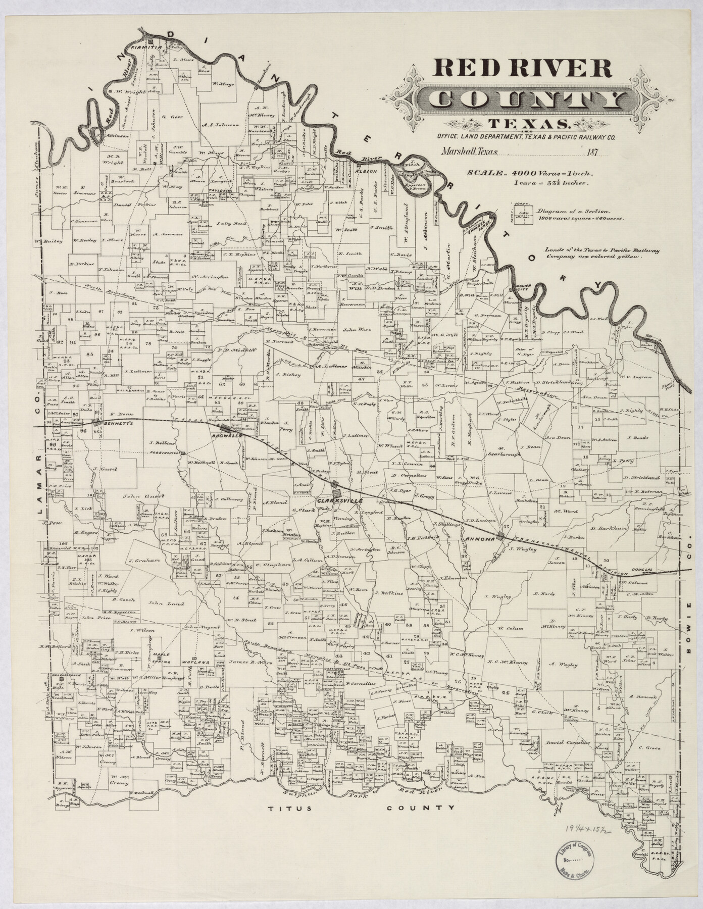
Red River County, Texas
-
Map/Doc
88989
-
Collection
Library of Congress
-
Object Dates
[1870-1879] (Creation Date)
-
People and Organizations
Land Department, Texas and Pacific Railway Company (Publisher)
-
Counties
Red River
-
Subjects
County
-
Height x Width
22.4 x 17.3 inches
56.9 x 43.9 cm
-
Comments
Prints available from the GLO courtesy of Library of Congress, Geography and Map Division.
Part of: Library of Congress


Map of Texas showing the Sabine and Galveston Bay Rail Road, or Texas and New Orleans Air Line Rail Line, its connections in the U.S. and adjacent territories.

Print $20.00
Map of Texas showing the Sabine and Galveston Bay Rail Road, or Texas and New Orleans Air Line Rail Line, its connections in the U.S. and adjacent territories.
1859
Size 28.7 x 41.3 inches
Map/Doc 93610
Colton's United States shewing the military stations, forts, &c

Print $20.00
Colton's United States shewing the military stations, forts, &c
1861
Size 14.6 x 17.3 inches
Map/Doc 93565
Schönberg's map of Texas.

Print $20.00
Schönberg's map of Texas.
1866
Size 11.0 x 13.0 inches
Map/Doc 93575
Provincias internas del Reyno de Nuevo España

Print $20.00
Provincias internas del Reyno de Nuevo España
1790
Size 31.0 x 24.0 inches
Map/Doc 95313
Map of Eastland Co[unty]
![88929, Map of Eastland Co[unty], Library of Congress](https://historictexasmaps.com/wmedia_w700/maps/88929.tif.jpg)
Print $20.00
Map of Eastland Co[unty]
1896
Size 45.0 x 42.8 inches
Map/Doc 88929
Hardeman Co[unty], Texas
![88946, Hardeman Co[unty], Texas, Library of Congress](https://historictexasmaps.com/wmedia_w700/maps/88946.tif.jpg)
Print $20.00
Hardeman Co[unty], Texas
1880
Size 27.8 x 23.7 inches
Map/Doc 88946
G. Woolworth Colton's new guide map of the United States & Canada, with railroads, counties, etc.

Print $20.00
G. Woolworth Colton's new guide map of the United States & Canada, with railroads, counties, etc.
1862
Size 30.3 x 36.6 inches
Map/Doc 93614
You may also like
[Surveys in the Jefferson District]
![3177, [Surveys in the Jefferson District], General Map Collection](https://historictexasmaps.com/wmedia_w700/maps/3177.tif.jpg)
Print $2.00
- Digital $50.00
[Surveys in the Jefferson District]
1841
Size 9.8 x 8.0 inches
Map/Doc 3177
Shackelford County Rolled Sketch 4A

Print $40.00
- Digital $50.00
Shackelford County Rolled Sketch 4A
1984
Size 35.2 x 48.7 inches
Map/Doc 9917
Armstrong County Sketch File 5

Print $40.00
- Digital $50.00
Armstrong County Sketch File 5
1887
Size 19.7 x 22.9 inches
Map/Doc 10841
[E. T. Ry. Blk. 1]
![89796, [E. T. Ry. Blk. 1], Twichell Survey Records](https://historictexasmaps.com/wmedia_w700/maps/89796-1.tif.jpg)
Print $40.00
- Digital $50.00
[E. T. Ry. Blk. 1]
Size 41.1 x 50.4 inches
Map/Doc 89796
Texas Gulf Coast, from the Sabine River to the Rio Grande as Subdivided for Mineral Development; Jefferson, Chambers and Galveston Counties

Print $20.00
- Digital $50.00
Texas Gulf Coast, from the Sabine River to the Rio Grande as Subdivided for Mineral Development; Jefferson, Chambers and Galveston Counties
1976
Size 29.0 x 42.5 inches
Map/Doc 1937
Sketch of surveys in Harrison & Marion Cos. showing Caddo Lake & Subdivisions

Print $5.00
- Digital $50.00
Sketch of surveys in Harrison & Marion Cos. showing Caddo Lake & Subdivisions
1955
Size 32.6 x 32.5 inches
Map/Doc 2895
[Sketch for M-12871 to M-13240 - Presidio County]
![65650, [Sketch for M-12871 to M-13240 - Presidio County], General Map Collection](https://historictexasmaps.com/wmedia_w700/maps/65650.tif.jpg)
Print $20.00
- Digital $50.00
[Sketch for M-12871 to M-13240 - Presidio County]
1927
Size 30.6 x 33.0 inches
Map/Doc 65650
Wichita County Working Sketch 10

Print $20.00
- Digital $50.00
Wichita County Working Sketch 10
1920
Size 25.4 x 16.1 inches
Map/Doc 72519
Cass County Working Sketch 47b

Print $20.00
- Digital $50.00
Cass County Working Sketch 47b
1992
Size 32.3 x 36.4 inches
Map/Doc 76063
Harris County Rolled Sketch 61

Print $20.00
- Digital $50.00
Harris County Rolled Sketch 61
1928
Size 25.7 x 26.8 inches
Map/Doc 6107
Leon County Working Sketch 46

Print $20.00
- Digital $50.00
Leon County Working Sketch 46
1980
Size 41.5 x 27.1 inches
Map/Doc 70445
Flight Mission No. BRE-4P, Frame 172, Nueces County

Print $20.00
- Digital $50.00
Flight Mission No. BRE-4P, Frame 172, Nueces County
1956
Size 18.4 x 22.1 inches
Map/Doc 86835