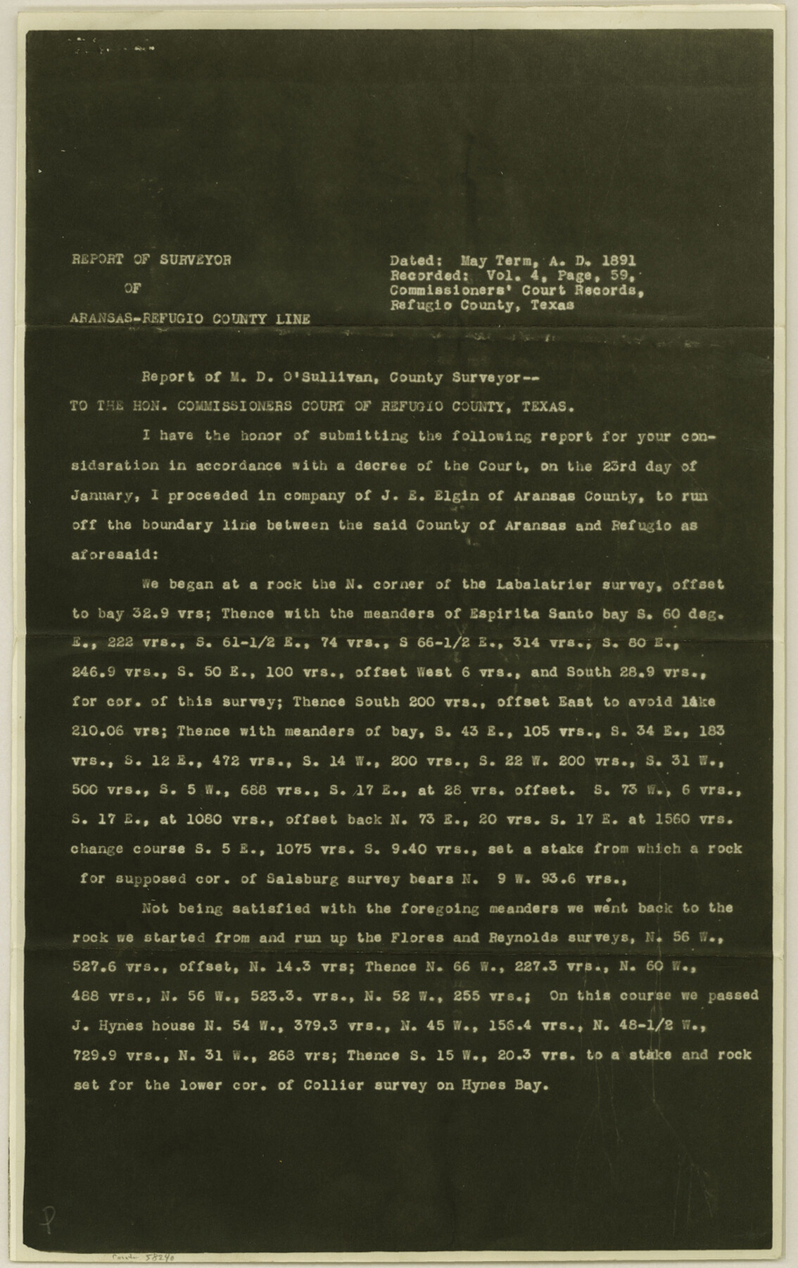
Refugio County Boundary File 2a
Refugio and Aransas Co. Bndry. Line
-
Map/Doc
58240
-
Collection
General Map Collection
-
Counties
Refugio
-
Subjects
County Boundaries
-
Height x Width
14.5 x 9.1 inches
36.8 x 23.1 cm
Part of: General Map Collection
Liberty County Sketch File 14

Print $4.00
- Digital $50.00
Liberty County Sketch File 14
1858
Size 12.9 x 8.1 inches
Map/Doc 29915
Polk County Working Sketch 2

Print $20.00
- Digital $50.00
Polk County Working Sketch 2
1909
Size 27.7 x 20.1 inches
Map/Doc 71617
Borden County Rolled Sketch 3

Print $20.00
- Digital $50.00
Borden County Rolled Sketch 3
1908
Size 29.0 x 33.6 inches
Map/Doc 5155
Harris County Historic Topographic 8

Print $20.00
- Digital $50.00
Harris County Historic Topographic 8
1916
Size 29.8 x 23.1 inches
Map/Doc 65818
Webb County Sketch File 13-1

Print $6.00
- Digital $50.00
Webb County Sketch File 13-1
Size 8.5 x 7.8 inches
Map/Doc 39804
Liberty County Sketch File 19

Print $6.00
- Digital $50.00
Liberty County Sketch File 19
1859
Size 13.6 x 9.4 inches
Map/Doc 29923
Ward County Rolled Sketch 24F

Print $40.00
- Digital $50.00
Ward County Rolled Sketch 24F
Size 30.5 x 65.2 inches
Map/Doc 78232
Brazoria County NRC Article 33.136 Sketch 16

Print $72.00
- Digital $50.00
Brazoria County NRC Article 33.136 Sketch 16
2014
Size 22.0 x 36.0 inches
Map/Doc 95037
Burnet County Working Sketch 22

Print $40.00
- Digital $50.00
Burnet County Working Sketch 22
1986
Size 40.5 x 50.9 inches
Map/Doc 67865
[Map of Matagorda County]
![3841, [Map of Matagorda County], General Map Collection](https://historictexasmaps.com/wmedia_w700/maps/3841-1.tif.jpg)
Print $20.00
- Digital $50.00
[Map of Matagorda County]
Size 24.4 x 25.6 inches
Map/Doc 3841
Waller County Sketch File 2

Print $52.00
- Digital $50.00
Waller County Sketch File 2
Size 13.3 x 9.0 inches
Map/Doc 39570
Gillespie County Sketch File 17

Print $8.00
- Digital $50.00
Gillespie County Sketch File 17
1994
Size 11.2 x 8.7 inches
Map/Doc 24157
You may also like
Sherman County Sketch File 6

Print $2.00
- Digital $50.00
Sherman County Sketch File 6
1993
Size 14.6 x 9.1 inches
Map/Doc 36724
La Salle County Sketch File 45

Print $40.00
- Digital $50.00
La Salle County Sketch File 45
1939
Size 16.9 x 14.2 inches
Map/Doc 29601
Edwards County Sketch File 5

Print $5.00
- Digital $50.00
Edwards County Sketch File 5
Size 9.0 x 3.9 inches
Map/Doc 21682
Ochiltree County Working Sketch 6

Print $20.00
- Digital $50.00
Ochiltree County Working Sketch 6
1962
Size 31.1 x 22.9 inches
Map/Doc 71319
Jasper County Working Sketch 11

Print $20.00
- Digital $50.00
Jasper County Working Sketch 11
1917
Size 20.2 x 23.4 inches
Map/Doc 66473
Map of Concho County

Print $20.00
- Digital $50.00
Map of Concho County
1862
Size 21.7 x 18.2 inches
Map/Doc 3435
Map of Power and Hewetson Colony

Print $20.00
- Digital $50.00
Map of Power and Hewetson Colony
1841
Size 34.8 x 24.3 inches
Map/Doc 1950
Map of Lampasas Co.

Print $20.00
- Digital $50.00
Map of Lampasas Co.
1888
Size 34.4 x 42.4 inches
Map/Doc 5080
Galveston County NRC Article 33.136 Location Key Sheet

Print $20.00
- Digital $50.00
Galveston County NRC Article 33.136 Location Key Sheet
1974
Size 27.0 x 23.0 inches
Map/Doc 77025
Texas, Matagorda Bay, Matagorda Peninsula, Central Section

Print $20.00
- Digital $50.00
Texas, Matagorda Bay, Matagorda Peninsula, Central Section
1933
Size 28.3 x 42.7 inches
Map/Doc 69987
Jasper County Working Sketch 18

Print $20.00
- Digital $50.00
Jasper County Working Sketch 18
1934
Size 22.4 x 30.5 inches
Map/Doc 66480
Right of Way and Track Map of The Missouri, Kansas & Texas Railway of Texas

Print $40.00
- Digital $50.00
Right of Way and Track Map of The Missouri, Kansas & Texas Railway of Texas
1918
Size 24.9 x 51.6 inches
Map/Doc 64535