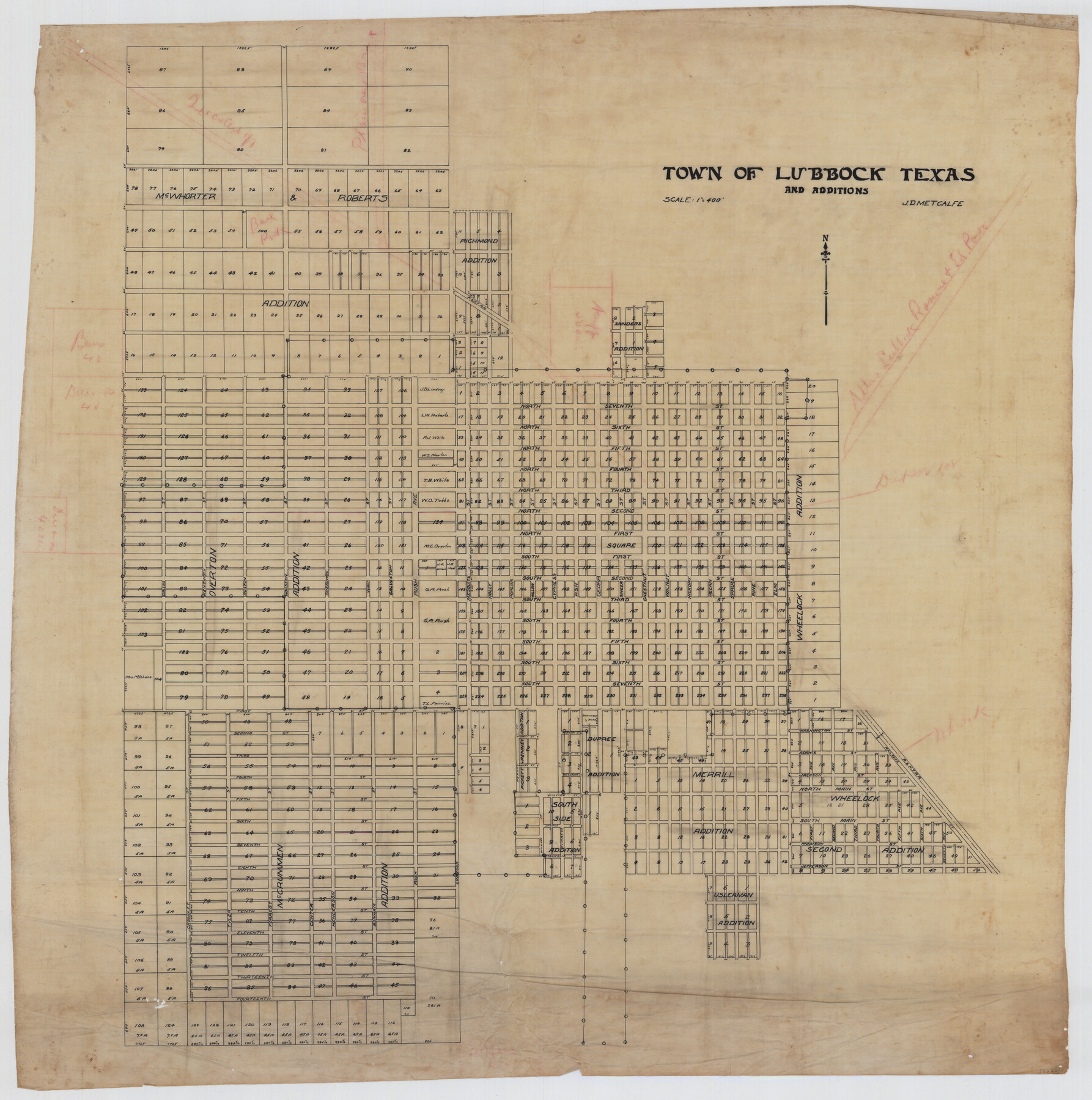
Town of Lubbock, Texas and Additions
-
Map/Doc
76271
-
Collection
Texas State Library and Archives
-
Object Dates
1935 (Creation Date)
-
People and Organizations
J.D. Metcalfe (Draftsman)
-
Counties
Lubbock
-
Subjects
City
-
Height x Width
43.8 x 43.5 inches
111.3 x 110.5 cm
-
Comments
Prints available courtesy of the Texas State Library and Archives.
More info can be found here: TSLAC Map 02222
Part of: Texas State Library and Archives
General Highway Map. Detail of Cities and Towns in Milam County, Texas [Rockdale and Cameron and vicinities]
![79598, General Highway Map. Detail of Cities and Towns in Milam County, Texas [Rockdale and Cameron and vicinities], Texas State Library and Archives](https://historictexasmaps.com/wmedia_w700/maps/79598.tif.jpg)
Print $20.00
General Highway Map. Detail of Cities and Towns in Milam County, Texas [Rockdale and Cameron and vicinities]
1961
Size 18.1 x 24.6 inches
Map/Doc 79598
General Highway Map, Roberts County, Texas

Print $20.00
General Highway Map, Roberts County, Texas
1940
Size 18.4 x 25.0 inches
Map/Doc 79229
General Highway Map, Cherokee County, Texas

Print $20.00
General Highway Map, Cherokee County, Texas
1939
Size 25.2 x 18.5 inches
Map/Doc 79045
General Highway Map, Caldwell County, Texas

Print $20.00
General Highway Map, Caldwell County, Texas
1961
Size 18.3 x 24.6 inches
Map/Doc 79394
Texas Oil and Gas Fields and Truck Pipe Line Systems

Print $20.00
Texas Oil and Gas Fields and Truck Pipe Line Systems
1926
Size 21.7 x 30.8 inches
Map/Doc 79327
General Highway Map, Nolan County, Texas

Print $20.00
General Highway Map, Nolan County, Texas
1961
Size 19.3 x 25.0 inches
Map/Doc 79614
General Highway Map, Concho County, Texas

Print $20.00
General Highway Map, Concho County, Texas
1940
Size 25.2 x 18.6 inches
Map/Doc 79057
General Highway Map, Delta County, Hopkins County, Texas

Print $20.00
General Highway Map, Delta County, Hopkins County, Texas
1940
Size 25.2 x 18.5 inches
Map/Doc 79073
General Highway Map, Swisher County, Texas

Print $20.00
General Highway Map, Swisher County, Texas
1961
Size 18.3 x 25.0 inches
Map/Doc 79663
General Highway Map, Shelby County, Texas

Print $20.00
General Highway Map, Shelby County, Texas
1940
Size 18.3 x 24.8 inches
Map/Doc 79242
General Highway Map, Orange County, Texas

Print $20.00
General Highway Map, Orange County, Texas
1940
Size 18.3 x 24.5 inches
Map/Doc 79212
General Highway Map, Lee County, Texas

Print $20.00
General Highway Map, Lee County, Texas
1961
Size 18.4 x 24.6 inches
Map/Doc 79567
You may also like
San Augustine County Working Sketch 16

Print $20.00
- Digital $50.00
San Augustine County Working Sketch 16
1962
Size 22.2 x 25.0 inches
Map/Doc 63704
Wheeler County Boundary File 1a

Print $2.00
- Digital $50.00
Wheeler County Boundary File 1a
Size 12.8 x 8.8 inches
Map/Doc 59868
Andrews County Rolled Sketch 20

Print $20.00
- Digital $50.00
Andrews County Rolled Sketch 20
Size 31.6 x 40.0 inches
Map/Doc 8395
Callahan County Sketch File 10a

Print $20.00
- Digital $50.00
Callahan County Sketch File 10a
1885
Size 14.3 x 8.8 inches
Map/Doc 35873
Houston County

Print $40.00
- Digital $50.00
Houston County
1944
Size 52.4 x 52.2 inches
Map/Doc 95534
Maverick County Sketch File 13a

Print $6.00
- Digital $50.00
Maverick County Sketch File 13a
1883
Size 14.1 x 8.8 inches
Map/Doc 31108
Crockett County Rolled Sketch RC

Print $50.00
- Digital $50.00
Crockett County Rolled Sketch RC
1935
Size 43.2 x 31.1 inches
Map/Doc 8702
Red River, Kelsey Sheet, Upshur County

Print $4.00
- Digital $50.00
Red River, Kelsey Sheet, Upshur County
1933
Size 21.1 x 24.2 inches
Map/Doc 65056


Map of Bell County

Print $40.00
- Digital $50.00
Map of Bell County
1896
Size 49.0 x 53.5 inches
Map/Doc 4768
Webb County Working Sketch 15

Print $20.00
- Digital $50.00
Webb County Working Sketch 15
1923
Size 18.8 x 30.4 inches
Map/Doc 72380