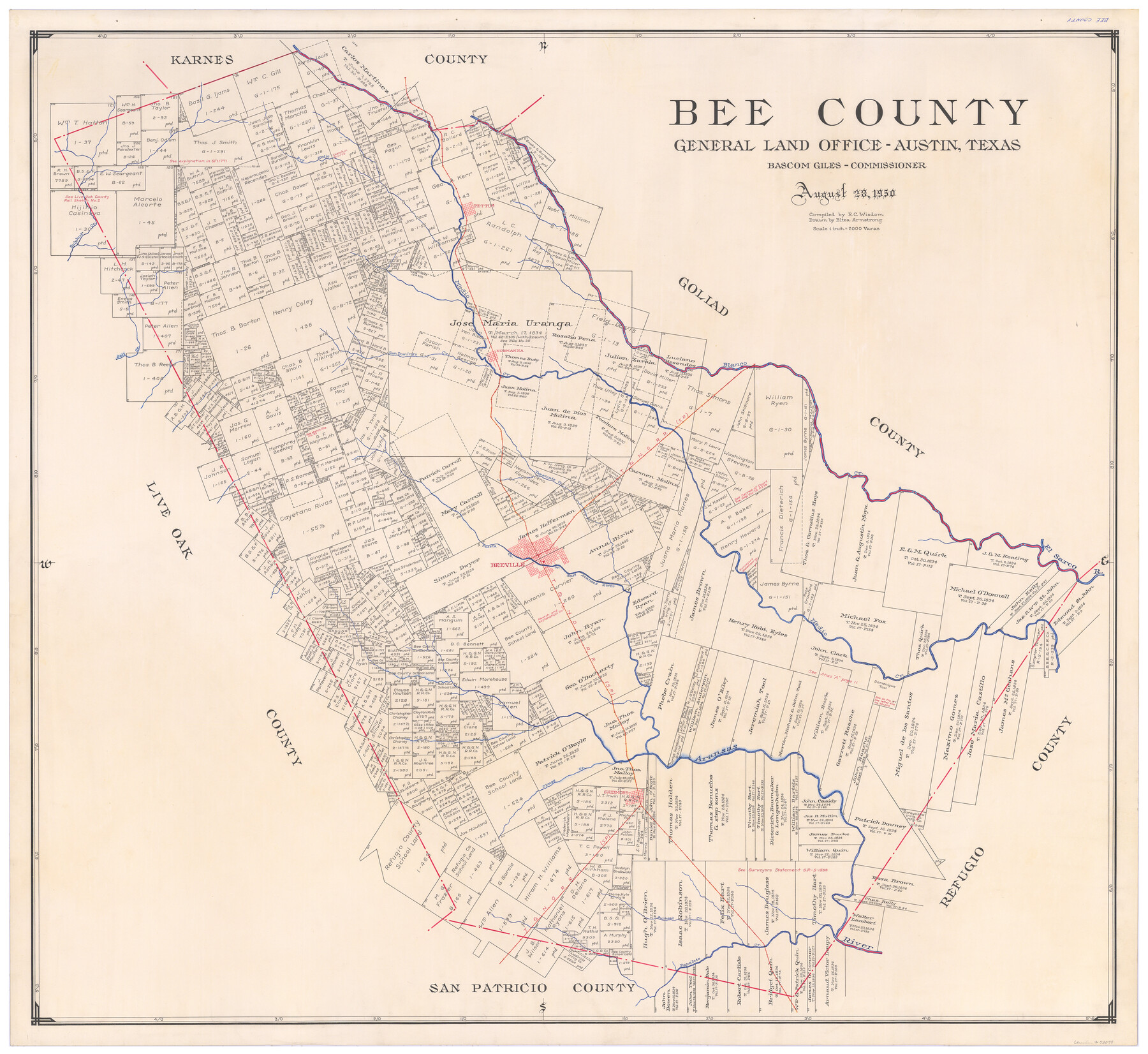
Bee County
-
Map/Doc
73078
-
Collection
General Map Collection
-
Object Dates
1950 (Creation Date)
-
People and Organizations
Texas General Land Office (Publisher)
Eltea Armstrong (Draftsman)
Bascom Giles (GLO Commissioner)
R.C. Wisdom (Compiler)
-
Counties
Bee
-
Subjects
County
-
Height x Width
42.6 x 45.9 inches
108.2 x 116.6 cm
-
Comments
Note on reverse side: "Put in official use, September 30, 1952."
-
Features
T&NO
Papalote Creek
Bullhead Creek
Aransas River
Skidmore
Olmos Creek
Paesta Creek
El Sarco River
Tapalcate Creek
Beeville
Dry Medio Creek
Blanco Creek
East Aransas River
Salt Creek
San Domingo Creek
Normanna
Medio Creek
Sulphur Creek
Pettus
Part of: General Map Collection
Harris County Sketch File 58

Print $20.00
- Digital $50.00
Harris County Sketch File 58
1920
Size 27.6 x 21.4 inches
Map/Doc 11657
Blanco County Sketch File 18

Print $4.00
- Digital $50.00
Blanco County Sketch File 18
1877
Size 12.6 x 8.5 inches
Map/Doc 14594
Kenedy County Rolled Sketch 17

Print $40.00
- Digital $50.00
Kenedy County Rolled Sketch 17
1958
Size 96.6 x 28.5 inches
Map/Doc 10726
Henderson County Sketch File 19

Print $4.00
- Digital $50.00
Henderson County Sketch File 19
Size 9.1 x 8.9 inches
Map/Doc 26363
Old Miscellaneous File 39

Print $10.00
- Digital $50.00
Old Miscellaneous File 39
1893
Size 14.2 x 8.8 inches
Map/Doc 75284
Hudspeth County Rolled Sketch 58

Print $20.00
- Digital $50.00
Hudspeth County Rolled Sketch 58
Size 31.4 x 32.6 inches
Map/Doc 6258
Map of Bandera County

Print $20.00
- Digital $50.00
Map of Bandera County
1862
Size 19.0 x 30.1 inches
Map/Doc 3271
Cherokee County Sketch File 7

Print $4.00
- Digital $50.00
Cherokee County Sketch File 7
Size 10.3 x 8.3 inches
Map/Doc 18128
Travis County Appraisal District Plat Map 3_0404

Print $20.00
- Digital $50.00
Travis County Appraisal District Plat Map 3_0404
Size 21.5 x 26.4 inches
Map/Doc 94226
Corpus Christi Harbor

Print $40.00
- Digital $50.00
Corpus Christi Harbor
1972
Size 36.9 x 52.3 inches
Map/Doc 73477
Loving County Rolled Sketch 5

Print $40.00
- Digital $50.00
Loving County Rolled Sketch 5
1952
Size 146.0 x 14.2 inches
Map/Doc 9467
Jefferson County Sketch File 33

Print $32.00
- Digital $50.00
Jefferson County Sketch File 33
1934
Size 8.2 x 7.6 inches
Map/Doc 28197
You may also like
Nolan County Sketch File 18

Print $8.00
- Digital $50.00
Nolan County Sketch File 18
Size 14.3 x 8.9 inches
Map/Doc 32489
Sutton County Rolled Sketch 56

Print $20.00
- Digital $50.00
Sutton County Rolled Sketch 56
Size 23.6 x 28.0 inches
Map/Doc 7895
Panola County Rolled Sketch 2

Print $20.00
- Digital $50.00
Panola County Rolled Sketch 2
1944
Size 20.7 x 27.0 inches
Map/Doc 7197
[Movements & Objectives of the 143rd & 144th Infantry and many other divisions and regiments, 1918] - Verso
![94139, [Movements & Objectives of the 143rd & 144th Infantry and many other divisions and regiments, 1918] - Verso, Non-GLO Digital Images](https://historictexasmaps.com/wmedia_w700/maps/94139-1.tif.jpg)
Print $40.00
[Movements & Objectives of the 143rd & 144th Infantry and many other divisions and regiments, 1918] - Verso
1918
Size 37.2 x 63.9 inches
Map/Doc 94139
![88993, San Jacinto Co[unty], Library of Congress](https://historictexasmaps.com/wmedia_w700/maps/88993.tif.jpg)
The Chief Justice County of Harrisburg. January 30, 1837

Print $20.00
The Chief Justice County of Harrisburg. January 30, 1837
2020
Size 17.5 x 21.7 inches
Map/Doc 96049
L'Amerique, divisée selon l[']etendue de ses principales parties, et dont les points principaux sont placez sur les observations de messieurs de l'Academie Royale des Sciences
![95688, L'Amerique, divisée selon l[']etendue de ses principales parties, et dont les points principaux sont placez sur les observations de messieurs de l'Academie Royale des Sciences, Holcomb Digital Map Collection](https://historictexasmaps.com/wmedia_w700/maps/95688.tif.jpg)
Print $40.00
- Digital $50.00
L'Amerique, divisée selon l[']etendue de ses principales parties, et dont les points principaux sont placez sur les observations de messieurs de l'Academie Royale des Sciences
1705
Size 44.9 x 65.4 inches
Map/Doc 95688
Panola County Working Sketch 17

Print $40.00
- Digital $50.00
Panola County Working Sketch 17
1945
Map/Doc 71426
Jefferson County Sketch File 51

Print $10.00
- Digital $50.00
Jefferson County Sketch File 51
Size 10.0 x 6.7 inches
Map/Doc 28249
Map of Texas and Parts of Adjoining Territories

Print $20.00
Map of Texas and Parts of Adjoining Territories
1899
Size 33.7 x 36.0 inches
Map/Doc 79304

Rusk County Sketch File 32

Print $20.00
Rusk County Sketch File 32
1949
Size 33.5 x 28.4 inches
Map/Doc 10596