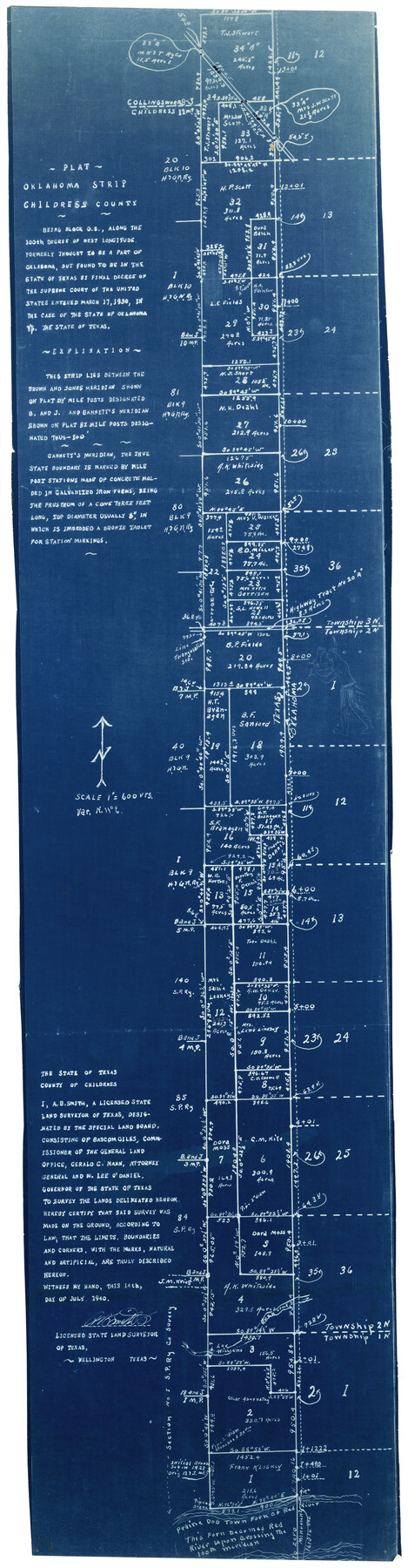
Childress County Rolled Sketch 10
Plat, Oklahoma Strip, Childress County being Block OS, along the 100th degree of west longitude formerly thought to be a part of Oklahoma. but found to be in the State of Texas by final decree of the Supreme Court of the United States
-
Map/Doc
8601
-
Collection
General Map Collection
-
Object Dates
7/14/1940 (Creation Date)
4/1/1941 (File Date)
-
People and Organizations
A.B. Smith (Surveyor/Engineer)
-
Counties
Childress
-
Subjects
Surveying Rolled Sketch
-
Height x Width
43.6 x 12.0 inches
110.7 x 30.5 cm
-
Medium
blueprint/diazo
-
Scale
1" = 600 varas
Part of: General Map Collection

PSL Field Notes for Blocks C1, C2, and C3 in Pecos and Reeves Counties

PSL Field Notes for Blocks C1, C2, and C3 in Pecos and Reeves Counties
Map/Doc 81669
Dallas County Working Sketch 16

Print $20.00
- Digital $50.00
Dallas County Working Sketch 16
1981
Size 15.7 x 12.0 inches
Map/Doc 68582
Irion County Rolled Sketch 12

Print $40.00
- Digital $50.00
Irion County Rolled Sketch 12
1945
Size 37.5 x 51.9 inches
Map/Doc 75943
Vicinity of San Luis Pass, Galveston Island, Texas

Print $40.00
- Digital $50.00
Vicinity of San Luis Pass, Galveston Island, Texas
1933
Size 36.9 x 57.2 inches
Map/Doc 69942
Pecos County Rolled Sketch 77

Print $20.00
- Digital $50.00
Pecos County Rolled Sketch 77
1930
Size 38.4 x 23.4 inches
Map/Doc 7238
Chambers County Working Sketch 30

Print $20.00
- Digital $50.00
Chambers County Working Sketch 30
2012
Size 29.2 x 43.9 inches
Map/Doc 93400
Coke County Sketch File 35

Print $6.00
- Digital $50.00
Coke County Sketch File 35
1967
Size 14.2 x 8.6 inches
Map/Doc 18649
Panola County Sketch File 25

Print $20.00
- Digital $50.00
Panola County Sketch File 25
1946
Size 24.1 x 21.4 inches
Map/Doc 12140
Foard County Rolled Sketch 16

Print $40.00
- Digital $50.00
Foard County Rolled Sketch 16
1889
Size 36.9 x 72.8 inches
Map/Doc 8893
Erath County Working Sketch 43

Print $20.00
- Digital $50.00
Erath County Working Sketch 43
1981
Size 19.6 x 15.7 inches
Map/Doc 69124

You may also like
Comal County Sketch File 21

Print $21.00
- Digital $50.00
Comal County Sketch File 21
1950
Size 9.1 x 11.4 inches
Map/Doc 19041
Flight Mission No. DAH-9M, Frame 161, Orange County

Print $20.00
- Digital $50.00
Flight Mission No. DAH-9M, Frame 161, Orange County
1953
Size 18.6 x 22.4 inches
Map/Doc 86860
King County Rolled Sketch 10

Print $20.00
- Digital $50.00
King County Rolled Sketch 10
Size 38.9 x 33.7 inches
Map/Doc 6532
Mills County Boundary File Index

Print $2.00
- Digital $50.00
Mills County Boundary File Index
Size 8.8 x 8.9 inches
Map/Doc 57258
Anderson County Working Sketch Graphic Index

Print $40.00
- Digital $50.00
Anderson County Working Sketch Graphic Index
1942
Size 52.0 x 48.3 inches
Map/Doc 76452
Archer County Working Sketch 24

Print $20.00
- Digital $50.00
Archer County Working Sketch 24
Size 21.0 x 35.8 inches
Map/Doc 67165
Amistad International Reservoir on Rio Grande 82

Print $20.00
- Digital $50.00
Amistad International Reservoir on Rio Grande 82
1949
Size 28.5 x 40.2 inches
Map/Doc 75511
[Surveys in McMullen and McGloin's Colony along the San Antonio River]
![30, [Surveys in McMullen and McGloin's Colony along the San Antonio River], General Map Collection](https://historictexasmaps.com/wmedia_w700/maps/30-1.tif.jpg)
Print $20.00
- Digital $50.00
[Surveys in McMullen and McGloin's Colony along the San Antonio River]
1828
Size 19.3 x 24.5 inches
Map/Doc 30
Bandera County Working Sketch 36

Print $20.00
- Digital $50.00
Bandera County Working Sketch 36
1966
Size 22.5 x 29.5 inches
Map/Doc 67632

Dimmit County Sketch File 50

Print $36.00
- Digital $50.00
Dimmit County Sketch File 50
1909
Size 18.2 x 20.4 inches
Map/Doc 21181
Deaf Smith County Sketch File 8

Print $20.00
- Digital $50.00
Deaf Smith County Sketch File 8
1988
Size 24.3 x 32.9 inches
Map/Doc 11304