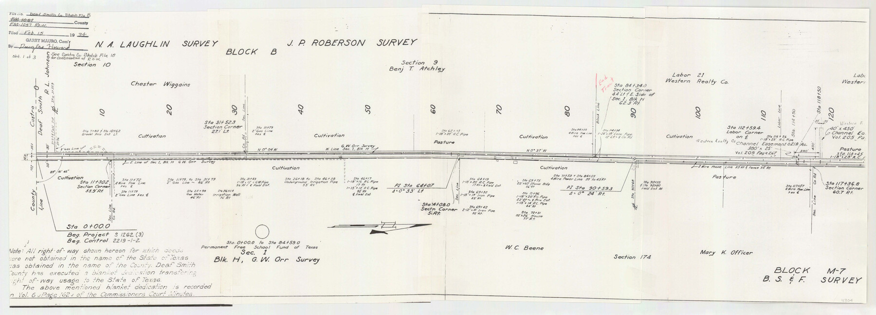
Deaf Smith County Sketch File 8
[Sketch of FM 1057 Right-of-Way alignment]
-
Map/Doc
11304
-
Collection
General Map Collection
-
Object Dates
1988/11/22 (Creation Date)
1994/2/15 (File Date)
-
People and Organizations
Texas Highway Department (Surveyor/Engineer)
-
Counties
Deaf Smith Castro
-
Subjects
Surveying Sketch File
-
Height x Width
24.3 x 32.9 inches
61.7 x 83.6 cm
-
Medium
blueprint/diazo
-
Comments
See Castro County Sketch File 18 (10330) for continuation of R.O.W.
-
Features
Locust Avenue
Second Street
Related maps
Castro County Sketch File 18

Print $20.00
- Digital $50.00
Castro County Sketch File 18
1988
Size 40.4 x 37.7 inches
Map/Doc 10330
Part of: General Map Collection
Rusk County Sketch File 47

Print $8.00
Rusk County Sketch File 47
Size 12.7 x 7.9 inches
Map/Doc 35597
Plat of survey in the North West portion of the Ramsey State Farm

Print $20.00
- Digital $50.00
Plat of survey in the North West portion of the Ramsey State Farm
1942
Size 25.9 x 30.4 inches
Map/Doc 94282
Starr County Rolled Sketch 8

Print $20.00
- Digital $50.00
Starr County Rolled Sketch 8
Size 21.5 x 29.6 inches
Map/Doc 7796
Irion County Sketch File 9

Print $14.00
- Digital $50.00
Irion County Sketch File 9
1927
Size 11.0 x 8.5 inches
Map/Doc 27475
Flight Mission No. DIX-10P, Frame 183, Aransas County

Print $20.00
- Digital $50.00
Flight Mission No. DIX-10P, Frame 183, Aransas County
1956
Size 18.4 x 22.1 inches
Map/Doc 83973
Denton County Sketch File 43

Print $20.00
- Digital $50.00
Denton County Sketch File 43
2006
Size 11.0 x 8.5 inches
Map/Doc 83610
Right of Way & Track Map, St. Louis, Brownsville & Mexico Ry. operated by St. Louis, Brownsville & Mexico Ry. Co.

Print $40.00
- Digital $50.00
Right of Way & Track Map, St. Louis, Brownsville & Mexico Ry. operated by St. Louis, Brownsville & Mexico Ry. Co.
1919
Size 25.6 x 57.1 inches
Map/Doc 64616
Cass County Rolled Sketch 8

Print $20.00
- Digital $50.00
Cass County Rolled Sketch 8
Size 28.8 x 17.6 inches
Map/Doc 77522
Map of Chambers Co.

Print $20.00
- Digital $50.00
Map of Chambers Co.
1901
Size 24.9 x 25.1 inches
Map/Doc 4907
Terrell County Working Sketch 8a

Print $20.00
- Digital $50.00
Terrell County Working Sketch 8a
1917
Size 14.5 x 19.4 inches
Map/Doc 62157
Denton County Working Sketch 18

Print $20.00
- Digital $50.00
Denton County Working Sketch 18
1975
Size 24.1 x 38.8 inches
Map/Doc 68623

You may also like
Kimble County Working Sketch 15

Print $20.00
- Digital $50.00
Kimble County Working Sketch 15
1923
Size 22.4 x 22.1 inches
Map/Doc 70083

Flight Mission No. CGI-1N, Frame 183, Cameron County

Print $20.00
- Digital $50.00
Flight Mission No. CGI-1N, Frame 183, Cameron County
1955
Size 18.8 x 22.2 inches
Map/Doc 84518
Maverick County Working Sketch 5

Print $40.00
- Digital $50.00
Maverick County Working Sketch 5
1944
Size 55.4 x 43.0 inches
Map/Doc 70897
[Surveying Sketch of Northern Portion of Hutchinson County]
![5065, [Surveying Sketch of Northern Portion of Hutchinson County], Maddox Collection](https://historictexasmaps.com/wmedia_w700/maps/5065.tif.jpg)
Print $20.00
- Digital $50.00
[Surveying Sketch of Northern Portion of Hutchinson County]
1890
Size 26.5 x 42.5 inches
Map/Doc 5065

Fisher County Sketch File Bb

Print $26.00
- Digital $50.00
Fisher County Sketch File Bb
1902
Size 14.3 x 8.7 inches
Map/Doc 22657
[State Capitol Leagues along Bailey-Lamb County Line]
![90163, [State Capitol Leagues along Bailey-Lamb County Line], Twichell Survey Records](https://historictexasmaps.com/wmedia_w700/maps/90163-1.tif.jpg)
Print $20.00
- Digital $50.00
[State Capitol Leagues along Bailey-Lamb County Line]
Size 20.7 x 21.3 inches
Map/Doc 90163
Crockett County Sketch File 12

Print $20.00
- Digital $50.00
Crockett County Sketch File 12
Size 26.8 x 18.9 inches
Map/Doc 11216
Culberson County Working Sketch 81

Print $40.00
- Digital $50.00
Culberson County Working Sketch 81
1980
Size 61.5 x 43.5 inches
Map/Doc 68535
Jefferson County Rolled Sketch 61A

Print $20.00
- Digital $50.00
Jefferson County Rolled Sketch 61A
1928
Size 27.2 x 40.4 inches
Map/Doc 6410
Kimble County

Print $40.00
- Digital $50.00
Kimble County
1890
Size 38.8 x 58.1 inches
Map/Doc 78414